The Moray Way
The Moray Way is Moray’s unique long-distance circular route, which follows the Moray Firth coast, crosses over moorland and tracks the river Spey. Few walks can match the range of scenery and wildlife found along the Moray Way. It can be walked comfortably in five to nine days.
- Long Distance Walk
- Challenging
- 100 miles (160 km)
- 850 meters (2788 ft)
- 9 day(s)
Accessibility: Suitable for a wide range of users
The route is primarily promoted for walking. Sections which make use of old railway lines are suitable for mountain bikes. The beach sections of the Way are ideal for horse riding. Sections of the Speyside Way along the old railway are suitable for horse riding. Cycling and horse riding on other sections of the way is not recommended due to physical condition and consideration for other users.
Terrain: Varied surfaces
There are a wide variety of surface types that make up the route ranging from sandy dunes to minor metalled roads.
Gradient: Mixed gradient
The Moray Coast Trail section is mostly flat with a rougher section between Burghead and Lossiemouth. The Dava Way involves gentle ascent and decent following the old railway line. The Speyside Way is mostly flat where it follows minor roads, tracks and an old railway, but has steep sections at Ben Aigen and near Cromdale.
- Fully signed
Report a route change
If you have followed this route and noticed any differences please report a route change by sending an email to:
Send us a GPX track
We would like to offer GPS tracks of all routes on this site.
If you are able to help please create a GPX track of this route (no detours) and send it to us for inclusion.
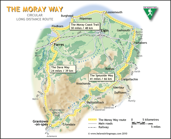
![]() The Moray Way combines the whole of The Dava Way, two-thirds of The Moray Coast Trail and approximately half of The Speyside Way creating a loop of a 100 miles (160 km), which can be walked in five to nine days and possessing a diversity of scenery unrivalled elsewhere in the UK.
The Moray Way combines the whole of The Dava Way, two-thirds of The Moray Coast Trail and approximately half of The Speyside Way creating a loop of a 100 miles (160 km), which can be walked in five to nine days and possessing a diversity of scenery unrivalled elsewhere in the UK.
Parts of the route are suitable for mountain biking and horse riding. Canoes or kayaks could be used down the River Spey providing an adventurous alternative.
The concept is the brainchild of the Moray Way Association, formed in 2009 to promote the route. Just over ten years later, Moray Way Association Committee Member Norman Thomson, in partnership with Birlinn, has written, The Moray Way, A Comprehensive Guide to The Dava Way, The Moray Coast Trail and the Speyside Way. For followers of this site, Birlinn has kindly offered a 20% discount on the publication (please use this code: MorayWay22 when purchasing)
History
The route takes in an area rich in history, from Pictish settlements at Burghead to the land of the real 11th Century Scottish King Macbeth around Forres, the original Highlands railway to the south which now forms the Dava Way path, and the whisky distilling heritage of the Speyside.
Nature
Be at the ready with your binoculars as The Moray Way has an impressive variety of wildlife; Minke Whale, Bottle Nosed dolphins, seals, otters, fulmars, red-throated divers, pine martens, capercaillie, osprey, buzzards, red squirrels, red and roe deer are just some of the main highlights that could be spotted on the route. Pop into the Dolphin Centre at Spey Bay or Burghead Visitors Centre for good dolphin viewing points.
Geology
The River Spey and the Moray Coast are internationally renowned for their outstanding natural heritage. The coastal sections of Moray consist of post-Caledonian sediments, Old Red Sandstone, and later Permo-Triassic desert sandstones of the Burghead to Lossiemouth stretch which can be viewed is a remnant of a former desert landscape of around 250 million years ago. At Clasach quarry, to the east of Hopemanyou can see the subtle colour changes in the sandstone, while the most prominent fault in Moray is located in adjacent Primrose Bay. Stone quarried near Hopeman was used in the Scottish parliament buildings and dinosaur footprints have been found around there, some of which are now housed at Kelvin Grove Art Gallery in Glasgow.
The uplands parts of the Speyside Way and Dava Way are part of the Grampian group of meta-sediments, initially deposited along the margins of the Laurentian continent about a billion years ago. These sediments were metamorphosed during the Caledonian orogeny (mountain building event) some 460-470 million years ago. At this time hard quartzite formations formed distinctive hills such as Beb Aigan and the Cromdale Hills which are part of distinctive views from many parts of the Moray Way. Even more distinctive is the granite intrusion of Ben Rinnes.
Terrain
The landscape along the route has many opportunities for great expansive views. The surface types that make up the route range from sandy dunes to minor metalled roads. There are some stiles, gates and short flights of steps along the route. There are no gates or stiles on the Moray Coast Trail but there are several on the Speyside Way and the Dava Way
Route
The route can be walked in either direction, starting and finishing at any point with many entry/exit points with car parking nearby. All of which can all be found on the Moray Way map.
The route is waymarked throughout, markers and fingerposts carry the logos of the Dava Way, Speyside Way (national trail symbol) and the Moray Coast Trail.
Getting Here
Forres has train services to Aberdeen and Inverness, and a bus service to Nairn, from where there is a connection to Inverness Airport. Grantown on Spey has regular buses to Aviemore railway station on the main Glasgow/Edinburgh to Inverness line. Lossiemouth, Fochabers, Hopeman and Burghead are served by buses from Elgin, which is on the Aberdeen-Inverness rail line.
For public transport information see: www.travelinescotland.com
Route Amendments
In published guides and maps, the route north of Forres crosses the rail line at a level crossing next to the Benromach Distillery. In October 2017 the crossing was closed as part of the Aberdeen to Inverness railway improvements.
Walkers can either follow the cycleway running along the B9011 between Forres and Kinloss or cross the railway via a new road immediately to the west of the (relocated) rail station to rejoin the route at the Benromach Distillery.
Maps and guides
A printed copy of The Moray Way map can be purchased from the Moray Way Association by sending a £4 cheque, made payable to the Moray Way Association, Bea Jefferson, c/o FACT, Town Hall, Forres, IV36 1PB.
Guides to the route with comprehensive maps and route descriptions are available from:
- Birlinn – The Moray Way, A Comprehensive Guide to The Dava Way, The Moray Coast Trail and the Speyside Way, July 2022, ISBN: 9781780277936
- Rucksack Readers – The Moray Coast Trail: with Dava Way and Moray Way, by Sandra Bardwell, November 2010, ISBN: 978-1-898481-40-9
- Cicerone Press –The Speyside Way: A Scottish Great Trail, includes the Dava Way and Moray Coast Trails by Alan Castle, December 2016, ISBN: 9781852848682
Accommodation and services
Cafés, restaurants, pubs and accommodation are plentiful on the Moray Coast and Speyside Way sections of the route, but somewhat sparse on the Dava Way. Accommodation on the Dava Way is available at the Dava School House alternatively, accommodation providers may be able to offer a pick up where the trail meets the A940 at Dava or Dunphail.
Details of accommodation providers are available from Moray Speyside Tourism or Visit Scotland.
It is advisable to book accommodation in advance.
Walking Tour Providers
Packages including accommodation and baggage transfer are available through Contours Walking Holidays.
Moray Way 5 Day Challenge
The North West Grampian Long Distance Walking Association, (LDWA), in partnership with the Dava Way Association and the Moray Walking and Outdoors Festival, occasionally organise an annual 5 day challenge walk of the Moray Way. Different levels of support are available for walkers, including a ‘park and ride’ facility, baggage transfer and camping options. Participants receive a passport to record their completion of the route and receive free hot drinks from participating cafes and restaurants.
Baggage transfer
Baggage transport can be arranged via Ace Taxis.
Itineraries
As the Moray Way is a circular route, it can be started at any point and walked clockwise or counterclockwise. This means that countless variations area available to itineraries so here are a few examples of how you could break down the route into stages.
A challenging 5-day counterclockwise walk, starting and finishing at Burghead.
Source: NW Grampian LDWA
- Day 1 Burghead to Dunphail 21 miles
- Day 2 Dunphail to Cromdale 18.5 miles
- Day 3 Cromdale to Aberlour 20.5 miles
- Day 4 Aberlour to Garmouth 18 miles
- Day 5 Garmouth to Burghead 17 miles
A 7 day clockwise walk, starting and finishing at Fochabers
Source: Contours Walking Holidays
- Day 1 Fochabers to Craigellachie 13 miles
- Day 2 Craigellachie to Ballindalloch 12 miles
- Day 3 Ballindalloch to Grantown-on-Spey 13 miles
- Day 4 Grantown-on-Spey to Dunphail* 14.5 miles
- Day 5 Dunphail* to Findhorn 14.5 miles
- Day 6 Findhorn to Lossiemouth 15.5 miles
- Day 7 Lossiemouth to Fochabers 13 miles
* No accommodation available at Dunphail – pick up required by taxi or accommodation provider. Accommodation is available at Forres (9 miles north) or Dava (6 miles south)
Note on mileage
Our initial mapping of the Moray Way gave us a length of 95 miles which is reflected in the stages above. The experience of walkers of the route using GPS trackers suggests that the total is nearer 100 miles. The difference appears to be due to rounding differences and walkers not taking the shortest route. We are not aware of anyone section being significantly different in length to the quoted distance on maps and guides.
Contact
Moray Council Outdoor Access Manager
- Ian Douglas
- Tel: 01343 557 049
- E-mail: ian.douglas@moray.gov.uk