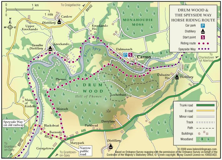
Archiestown Woods

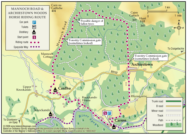
This is a circular route of about twelve miles through forestry and on quiet public roads. It connects with the Speyside Way and the Drum Wood circular route. The Mannoch Road is an ancient right of way that runs from Elgin to Knockando; the name comes from the Gaelic work for monk.

    Balloch Wood and Hill

    The Balloch forest covers about 2,500 acres and has a network of forest roads so a variety of routes are possible.  At the southwest end you can follow part of Governor Caulfeild’s military road, built about 1750, which ran from Stonehaven to Fochabers.

      Ben Aigan and Knockmore

      This ride takes you to the transmitter on Knockmore, the summit of Ben Aigan and stunning views of Speyside. The route described is not way-marked by the Forestry Commission as a horse-riding trail.

      • Terrain: Varied surfaces

        Mostly forest roads, some open moorland and one steep grassy track. The climb to the summit is very stony.

      • Mixed gradient

      Cabrach

      This is a pleasant and scenic all day ride across open moorland with some good views from the slopes of Cook’s Cairn. Quite a bit of wildlife to see including large herds of deer.

      • Terrain: Varied surfaces

        Some good estate tracks suitable for fast trotting; the higher moorland tracks are rougher and more stony.

      Drum Wood

      This is a nice easy circular route that takes in a few miles of the Speyside Way and returns through forestry on the other side of the river. Good views to the north from the Drum Wood and very scenic alongside the Spey. This route is not waymarked and part of it runs through private land.

      • 10 miles (16 km)
      • 120 meters (393 ft)
      • Varied surfaces

      Loch Romach and Altyre Estate

      Views across the Cromarty Firth are magnificent from the High Drive on Altyre Estate. Some of this route follows the Dava Way which is way-marked but much is on private land.

        Lossie Forest & Beach

        This ride takes you through the forest from Kingston towards Lossiemouth and back either through the forest or along the edge of the beach.

        • Terrain: Coastal tracks

          Good firm sand on the beach and reasonably soft forest tracks. 

        • Generally level
        • No barriers

        Roseisle Beach

        A very pleasant, long beach ride. Roseisle Beach stretches for nearly eight miles from Findhorn in the west to Burghead in the east. The route described is not way-marked or maintained by the Commission as a horse-riding route.

        • Terrain: Coastal tracks

          Once across the softer sand and gravelly patches the beach sand is good and level and firm although keep an eye out for soft spots/hidden rocks/small 'streams' of water.

        • Generally level
        • No barriers
        • Partly signed

        The Dava Way (Horse Ride)

        This is a long distance route that runs from Forres to Grantown, mostly following the old railway line. It has superb scenery with woods and forests at both ends, extensive heather moorland in the middle and a dramatic valley crossing on a viaduct.

          Tiendland Trails

          Teindland is a large forest south-east of Elgin with an extensive network of roads and tracks that can be explored.