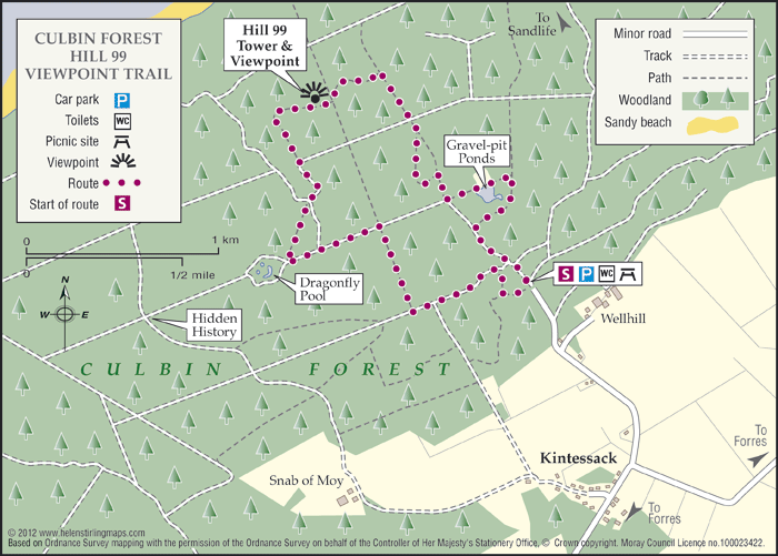
Culbin Forest- Route 99
One of Moray’s many Forestry Commissions woodlands with promoted access, it is located on the coastal sand dunes between Findhorn Bay and Nairn. It has a wide network of paths suitable for many users, including the signed all abilities trail, known as the Route 99.
- Low Level Walk
- Easy
- 2 hour(s)
- Kintessack
Accessibility: Accessible for all users
Horse riders are better catered for at the Cloddymoss car park.
- Generally level
- Fully signed
Report a route change
If you have followed this route and noticed any differences please report a route change by sending an email to:
Send us a GPX track
We would like to offer GPS tracks of all routes on this site.
If you are able to help please create a GPX track of this route (no detours) and send it to us for inclusion.
Start Point – Wellhead Car Park
This is a signed and promoted route which is ideal for first-time visitors. It’ll lead you along winding sandy paths, through forest and mossy clearings. The route up to Hill 99 and its ‘squirrel’s-eye’ viewpoint is well worth it. It’s suitable for nearly all abilities and takes a gentle gradient.
Why Hill 99? Probably named by early foresters, this is Culbin’s tallest dune at 99 feet. The circular route onwards from the summit has a few steeper sections that less able visitors might avoid by going back down the way they came. For others, the firm, waymarked path completes the circuit back to the car park.
Contact
Moray Council Outdoor Access Manager
- Hector Bryden
- E-mail: morayaccess@moray.gov.uk
Contact
Forestry and Land Scotland – Huntly Office
- Tel: 0300 067 6380
- Portsoy Road, Huntly AB54 4SH
- Email: enquiries.east@forestryandland.gov.scot