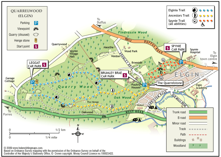
Elgin – Quarrelwood Ancestors Trail
The Ancestor’s Trail meanders through the beautiful Oakwood part of which is an ancient semi natural wood.
- Low Level Walk
- Easy
- 2.5 miles (4 km)
- 1h 30 minutes
- Elgin
- Suitable for a wide range of users
Terrain: Forest tracks
The path surface is of woodland earth which can be muddy when wet and undulating with exposed tree roots.
Gradient: Undulating
Some steep parts, undulating terrain
Report a route change
If you have followed this route and noticed any differences please report a route change by sending an email to:
The Ancestor’s Trail is a circular route that starts at Brumley Brae car park & meanders through the beautiful Oakwood. It visits the ditches & banks, the remains of a 4,000-year-old Henge which may have been used for ceremonies by our ancient ancestors. As well as the route described here, there are a variety of short walks & links to other path networks.
The walk begins from the car park beside the road on Brumley Brae. It is waymarked by engraved stones, some standing, some laid flat, placed beside the path. They are carved with a human footprint, symbolising man’s presence in these woodlands over thousands of years. These stones can be difficult to spot amongst the path side undergrowth.
From the end of the car park do not take the main track past the barrier. Instead, go down the smaller path that descends to the left of it.
When this meets another path at a T-junction, turn left. Almost immediately a series of large upright stones are reached. One bears an information board about the woodlands.
Turn right, downhill from the stones & head down the steps. Turn right at the bottom of the steps to join a path contouring through the woods. It soon passes a bench, the first of three benches on this section of path.
After a while, you reach a second bench, on the right, set back from the path a little. Keep straight ahead here. Do not be confused by the marker stone on a path to the right – it is for the return route. Following some further distance, you reach a third bench, here take the right fork that continues ahead. You may start to hear the traffic on the nearby A96 main road.
Continue ahead on this path, ignoring further junctions. The path soon climbs gently to the right and, for a while, runs parallel to, but not near, the main road. Again ignore paths off to the left or right until a crossroads with a marker stone is reached. Be alert because the stone is laid flat & can easily be missed in the undergrowth. Turn right here. Keep ahead, uphill, ignoring paths off to the left or right.
When a wide track is reached keep ahead, ignoring paths off to the left or right. Just beyond an obvious orienteering postmarked “15”, the path meets a fence corner on the left. Turn right here, uphill.
For a while, you can follow the prominent wooden marker posts banded red, as this section shares the path with another walk, the Elginia Trail. The red posts & stones carved with a reptile’s footprint are its waymarkers. Follow the path ahead until it reaches a wide space, probably a turning circle for forestry vehicles. Turn right along what is initially a track.
Look out for a red post & marker stone at an otherwise easily missed junction where you need to turn right. Once you’ve turned you should be able to see ahead to a large boulder with an information board. Go to the boulder, which is at the entrance to a large clearing. This is the 4,000-year-old Henge at the heart of the woods. The ditch & low earth ramparts encircling it are still visible amongst the vegetation.
Turn left behind the boulder & follow the path, keeping the Henge & the remains of a drystane dyke on your right. Keep straight ahead, downhill, past a bench & a pond. The Ancestor’s Trail & Elginia Trail soon diverge, so do not follow the red marker posts when they take a path off to the left. Instead, continue ahead as the path broadens out.
At the end of the broad track, there is a crossroads besides a bench & broken-down fencing. Turn right downhill here. Continue downhill, ignoring various paths off the to left or right. Eventually, the path reaches a crossroads close to the second bench that you passed on your outward journey. Turn left here & retrace your steps back to the car park.