Lossie Forest & Beach
This ride takes you through the forest from Kingston towards Lossiemouth and back either through the forest or along the edge of the beach.
- Horse Ride
- 11 miles (17.6 km)
- Kingston
Terrain: Coastal tracks
Good firm sand on the beach and reasonably soft forest tracks.
- Generally level
Report a route change
If you have followed this route and noticed any differences please report a route change by sending an email to:
Send us a GPX track
We would like to offer GPS tracks of all routes on this site.
If you are able to help please create a GPX track of this route (no detours) and send it to us for inclusion.
Please note that this route is not way-marked by the Forestry Commission and that it crosses some private land. We
suggest that you also carry an Ordnance Survey map and compass so you do not get lost in the forest.
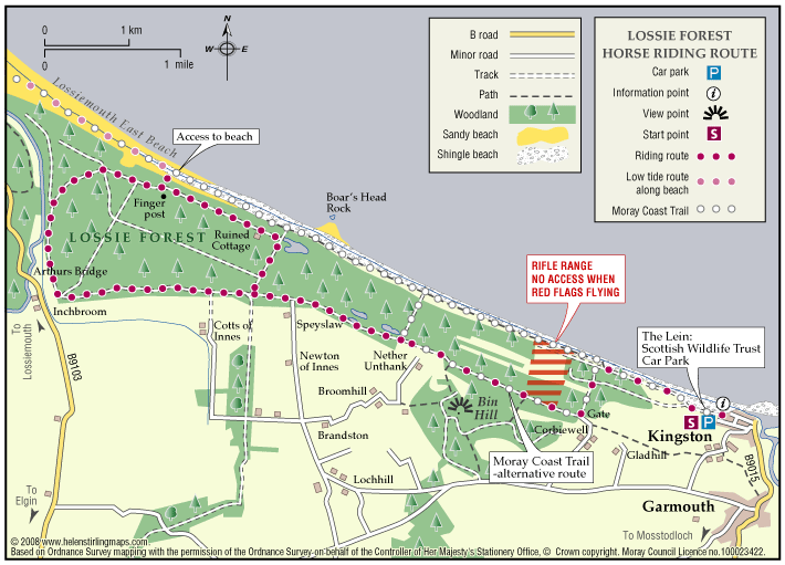
Access & Parking: The best access is from the Scottish Wildlife Trust’s car-park at The Lein, just west of Kingston, at grid reference NJ 332656.
This route takes you past a rifle range, so access is occasionally be restricted. Watch out for the red flags.
Follow the track closest to the beach westward from the car-park. When you come to the fence turn left (south), and follow the narrow track for about 500 yards until you come to a gate on your right into the forest. This may be padlocked with a standard Forestry Commission key. If it is locked (it isn’t always) you will probably need to dismount as the vehicle barriers are a bit awkward. Beware of loose wire. After this a nice grassy track takes you past the rifle range.
After 2.5 miles, turn left and immediately right at the staggered junction and follow the good forest road along the edge of the forest. At the car-park at Arthur’s Bridge go through both gates then turn sharp right, just after the cottage, onto a narrow track and go past a pole barrier. After about three quarters of a mile bear right at a fork. After another quarter of a mile go straight across the main forest road. Shortly afterwards a green ‘finger post’ sign points left to the beach. If the tide is out you can go down here, over the shingle and onto the sandy beach which is good for a canter. Other wise continue straight on the track for a mile until a derelict cottage in a large clearing. Just after this there is a junction and you have two options.
1 The more interesting way is to turn left along a firebreak (signposted) which brings you out of the forest to a large shingle bank. The beach is stony here and you cannot ride on it. Turn right and follow the waymarked Moray Coastal Trail, which runs in the depression between the shingle bank and the forest, back to the parking area. Beware of rabbit holes and ditches.
2 Alternatively, if you turn right, and then left after half a mile just, beyond a quarry, turn left and rejoin your outward route. There a quite a few other tracks you can explore but this route will help you get your bearings. It used to be possible to ride to the top of the Bin Hill but this can be very overgrown with bracken in the summer.
Always check the tide tables as the good sand for riding is only exposed at very low tide. It is safest to arrive about three hours after high tide, that way you will be riding as the tide is going out rather than coming in. Tide times are published daily in the P&J and there is a link to the Hydrographic Office website on the ‘Where to ride page’ of the MEAG website.