The Dava Way (Horse Ride)
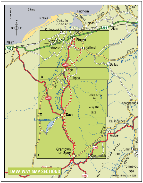
This is a long distance route that runs from Forres to Grantown, mostly following the old railway line. It has superb scenery with woods and forests at both ends, extensive heather moorland in the middle and a dramatic valley crossing on a viaduct.
- Horse Ride
- 27 miles (43.2 km)
- Forres, Rafford
Report a route change
If you have followed this route and noticed any differences please report a route change by sending an email to:
Send us a GPX track
We would like to offer GPS tracks of all routes on this site.
If you are able to help please create a GPX track of this route (no detours) and send it to us for inclusion.
Gallery
You will need to detour around a couple of sections that are not really suitable for horses. The going is mostly good and there are many sections where you can canter – interrupted only by the many gates. It makes a good two day trip – ride from one end to the other and return the next day.
Location: Follows the old Grantown to Forres railway line.
Map: Landranger #27 Forres and Nairn and 36 Grantown and Aviemore
Going: Quite varied: short sections of minor public road; mostly grassy; some short stony sections.
In one place you have to go along the main road for 400 yards (on a wide verge). Some of the gates are narrow and there are also a couple of awkward bridges to cross
Access & Parking: The route can be accessed from many points but there are no dedicated parking areas suitable for riders.
The route is still under development. This means that it is not shown on any OS maps, nor are there any detailed guidebooks or leaflets. The Way is a proposed Core Path so further improvements are planned. If planning a ride along the Way it would be a good idea to speak to someone who is familiar with it or do some exploring first. On horseback we recommend riding from the north and over-nighting at Grantown.
For the most part it follows the railway line, though in a couple of places it runs on forest tracks parallel to the railway. These sections are well marked and obvious. There are a few detours where the Way leaves the railway line and there are other places where the Way is less attractive to riders and we recommend an alternative route.
You can join the route at several points – these are marked with yellow arrows on the map.
However there are only two car-parks on the route that are suitable for horseboxes or trailers. These are at Dallas Dhu and Newtyle. Elsewhere you will just have to find somewhere to park as best you can.
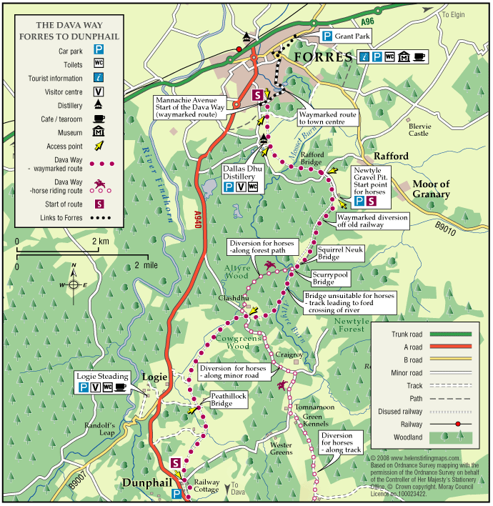
From the north the suggested riding route starts at the car-park at the Newtyle Gravel Pit.
Follow the waymarked route south until the Squirrel Neuk Bridge where you reach the first detour.
This is to avoid a bridge that is too narrow for riders. At grid ref NJ042535, leave the way and get onto the track on the east side, cross above the Dava Way on the bridge and follow the forest road to the south-west. Take the second forest road on the left (after about one mile) and follow this back to the Dava Way – its a bit indeterminate at the end. Go down a bank and on the Way. Turn left and after only a few yards turn right onto a track. Follow this for about 300 yards then fork left onto a nice grassy track that turns uphill and leads you to Craigroy farm – you follow a deep gully with a burn on your left side.
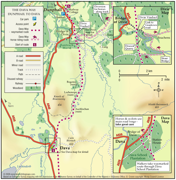
Just after Craigroy continue straight ahead on the public road and after one mile, opposite Tomnamoon, turn left and follow the track past Green Kennels and keep on going, gently climbing uphill and passing a couple of gates. After the top of the hill bear right and follow the track, now tarmac, downhill to the Divie viaduct. Just before the viaduct, take the road on the left which leads you across the river and when you go uphill bear right onto a track that leads you back onto the Way. Follow this for several miles.
At about NJ026429 there is a locked gate and the slip gate is rather awkward – see photo. MEAG is on the case here, check the main website for the latest news.
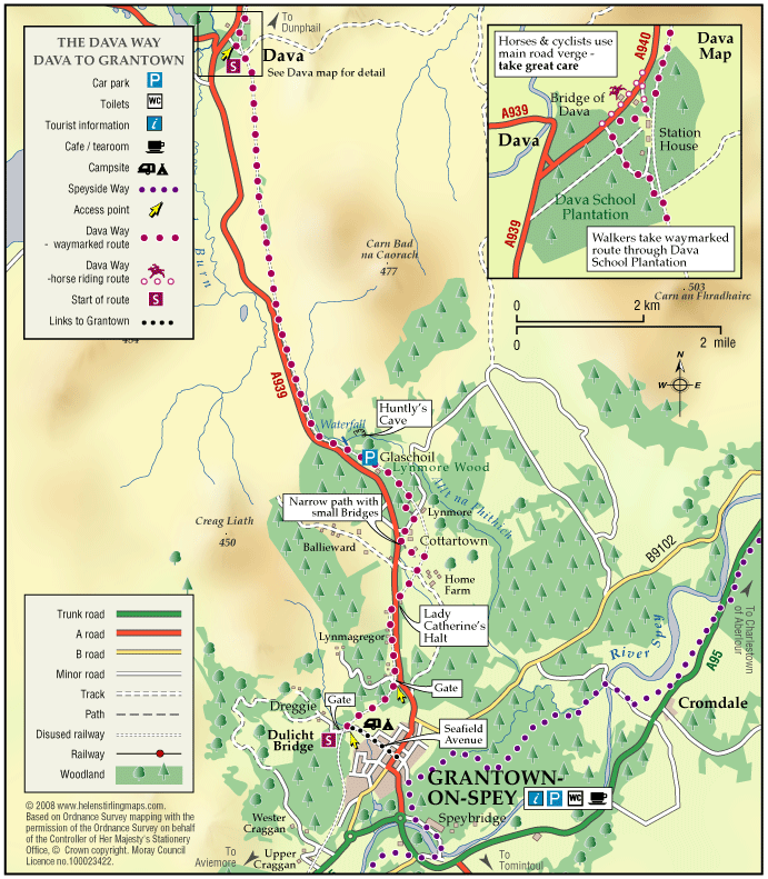
At Dava the Way passes some houses and the path detours through some trees it is very soft with a couple of small bridges that are best avoided. Here follow the track on the right then ride along the verge beside the main road for 400 yards and turn left up a forest road to rejoin the railway. Follow the railway again for miles. This middle moorland section is quite exposed and much of the route is somewhat remote and isolated; there are no shops or facilities on route.
Just before Cottarton follow the way-marked detour through the woodland, rejoining the Way about a mile further south. This section has two narrow bridges (dismount and lead across) and also follows a narrow path squeezed between trees and the roadside fence. You may wish to keep a pruning saw handy for this bit.
From here stay on the Way into Grantown – you will also need a good head for heights as you cross the bridge over the main road at Lady Catherine’s Halt.Shortly after this there is a gate that may be locked. You can by-pass this by going ten yards downhill on the road and squeeze through the trees.
Curently you can also arrange for the gate to be opened by contacting Jackie Douglas, 01479 870232.
The recommended route ends at the Dulicht Bridge.
You can overnight the horses in a field half a mile further south. To get here continue on along the Way, through the industrial estate. To make arrangements to use this field, contact Scilla Laing – scillalaing@ukf.net
There are several B&Bs in Grantown and also a good campsite ( team@caravanscotland.com ) and bunkhouse. Several of these cater for walkers on the Speyside Way which passes through the town and may be able to offer a pick-up service. Sorry, but at the moment we are unable to advise of any that can willingly accommodate tack so you will need to make enquiries about this.
For more information on this route, contact Fiona Preston – maudrid@hotmail.com
Comprehensive information is also available on the Dava Way website www.davaway.org.uk