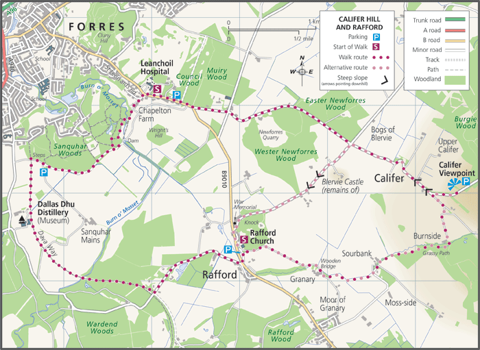
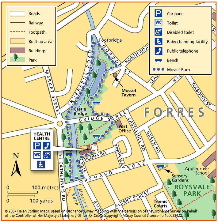
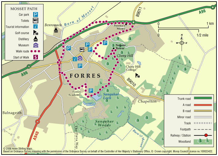
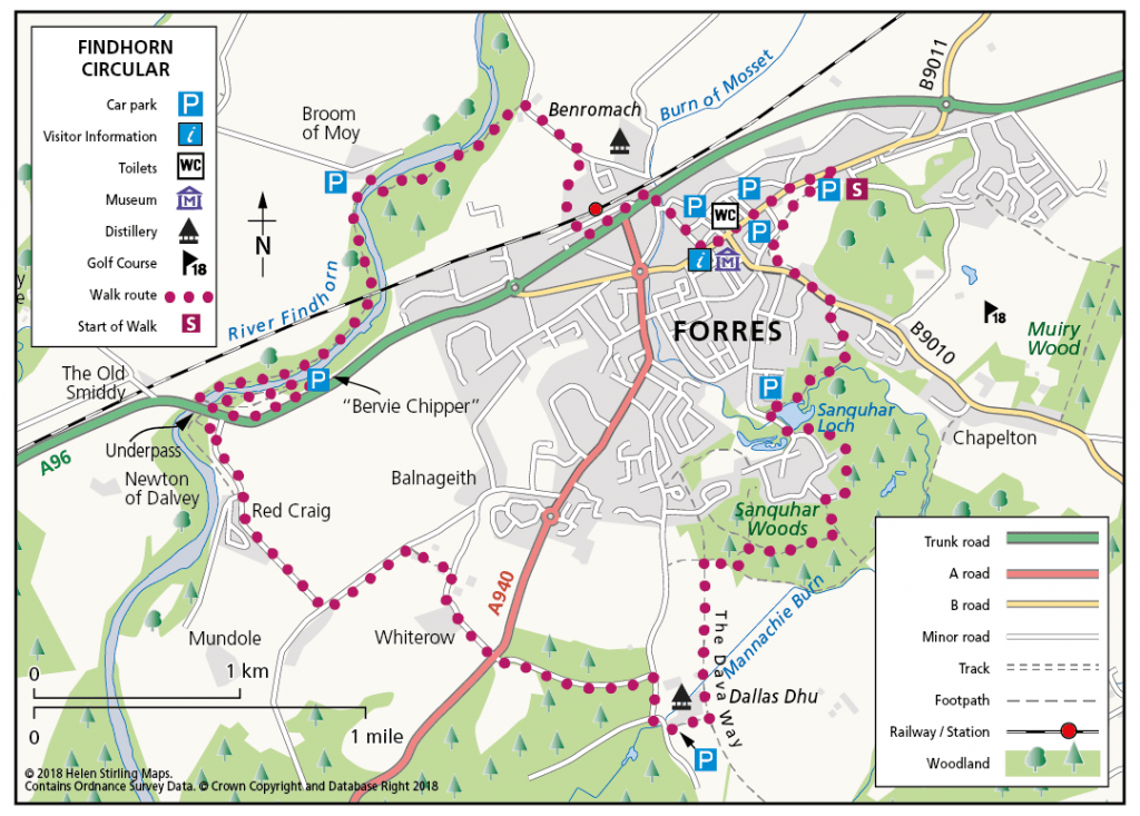
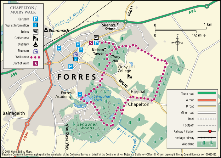
Forres – Burn of Mosset & Altyre Burn

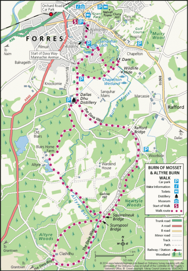
This circular walk explores the Burn o Mosset as it starts to flow through Forres and then takes you to the earlier stages of the stream which starts as the Altyre Burn. The route uses the Dava Way to head South from Forres before returning through forestry estates with good views at several stages of the walk. The walk can be shortened to 8 miles by starting at the Dallas Dhu distillery.

  • Suitable for a wide range of users
  • Varied surfaces
  • Unsigned

Forres – Califer Hill & Rafford

A circular walk along minor roads and footpaths with stunning views from Califer Viewpoint, returning via lower Rafford and the Dava Way with a shorter route option from Rafford Church available.

  • Suitable for a wide range of users
  • Terrain: Varied surfaces

    Minor Roads, Grassy Lanes, Farm Tracks, Footpaths, Woodland Tracks, some potentially muddy and slippy parts following wet weather and some narrower sections.

  • Gradient: Generally level

    Most of this route is relatively level with the steepest section being the ascent and descent to and from Califer Hill Viewpoint.  The viewpoint ascends to 184.5m.

  • Barriers:

    There are footbridges to cross and some narrower sections.

  • Unsigned

Forres – Cluny Hill Path

This is a circular route on good paths with 1 steep road section at the start but then relatively flat. The walk is under a tree canopy most of the time. In autumn and winter the fallen leaves can be knee high! You can extend the walk by joining other paths round the hill.

  • Suitable for buggies but not wheelchairs
  • Terrain: Paved footpaths & roads

    Tarmac and gravel paths - can be muddy.

  • Gradient: Generally level

    One steep road section, then generally level.

Forres – Engineering Past and Present

An interesting and varied circular walk on the outskirts of Forres which visits some of the engineering projects that have changed the local landscape from the 19th century to the present day.

  • Suitable for a wide range of users
  • Terrain: Varied surfaces

    Mixture of tarmacked paths, stepped sections, woodland tracks and earth paths with some undulating sections.

  • Generally level
  • Barriers: Some barriers

    There are a few stepped sections and two wooden bridge crossings over the Burn o' Mosset.

  • Unsigned

Forres – Grant Park

This is a pleasant circular route through parkland, on good paths around the park. There are places to rest in the park. In spring and summer the flowerbeds are very picturesque. In autumn the trees are spectacular but beware of fallen leaves on the paths, which can make them very slippy if wet. You can extend this walk by joining onto Cluny Hill paths.

  • Accessible for all users
  • Paved footpaths & roads
  • Generally level

Forres – Mosset Burn

This is a very pleasant walk with trees, flowerbeds and birds. The paths are all good although if it has been very wet they may be a little muddy in places. There are places to sit and rest throughout the walk. You’ll need to take care crossing over Bridge Street.

  • Accessible for all users
  • Terrain: Paved footpaths & roads

    Gravel footpaths can be muddy.

  • Gradient: Generally level

    Mainly level but some downward slopes through park.

Forres – Mosset Walk

A circular walk around Forres, taking in the picturesque Sanquhar Loch, the panoramic view from the Nelson Tower at the top of Cluny Hill and a fine view of the town from Councillor’s Walk. 

  • Unsuitable for wheelchairs and buggies
  • Terrain: Paved footpaths & roads

    Take care on the two A96 road crossings.

  • Gradient: Short steep sections

    A fairly steep path within Grant Park leading up to Nelson Tower. Otherwise, generally level with only a few gentle slopes.

  • Barriers: Some barriers

    Kissing Gates (2), and steps.

  • Fully signed

Forres – Nelson’s Monument Walk

This is a circular walk through woodland on good paths with some steady climbs and descents. The paths can be muddy or full of leaves depending on weather conditions and time of year. The view from the top of the hill is spectacular. The Tower is open between Tuesday to Sunday from 2pm – 4pm during May and September. If you can manage the stairs, on a clear day you can see Findhorn Bay and over the Moray Firth to the hills of Easter Ross and Sutherland.

  • Unsuitable for wheelchairs and buggies
  • Terrain: Varied surfaces

    Tarmac and gravel footpaths - can be muddy.

  • Undulating

Forres – River Findhorn Circular

A circular walk through and around the town of Forres, following the banks of the River Findhorn for much of the route. With some fine views of the surrounding countryside it explores some attractive, yet less frequented, environs of this pretty Moray town.

  • Accessibility: Unsuitable for wheelchairs and buggies

    Suitable for most abilities of walker, but the length of the walk and the steps may restrict access some users.

  • Terrain: Varied surfaces

    Mainly tarmac paths and pavements, quiet country road, and gravel tracks. There are a few sections of earth paths through the woodland and along the river. The route along the river goes under the A96 bridge, where great care should be taken if the river is in spate. Also take care at the A96 road crossing.

  • Gradient: Generally level

    Relatively level with only a few gentle gradients.

  • Barriers: Some barriers

    One large flight leading onto the Dava Way near Sanquhar Wood, and another on the north bank of the River Findhorn.

  • Fully signed

Forres – Roysvale Park

This is a flat circular route, all on pavements so suitable for wheelchairs and buggies. The Sensory Garden in Orchard Road is worth a short stop to smell the aromatic plants. There is a bench there and also one in front of the Leisure Centre. You can extend this walk to include Sanquhar Loch.

  • Accessible for all users
  • Paved footpaths & roads
  • Generally level
  • No barriers

Forres – Sanquhar Chapelton Muiry

A circular walk around the southern outskirts of Forres taking in Sanquhar Loch and Woodlands, Cluny Hill and an unexpected glimpse of Findhorn Bay.

  • Unsuitable for wheelchairs and buggies
  • Terrain: Varied surfaces

    Pavements, tarmac and gravel paths. There are also some sections of earth path through the woodland areas.

  • Mixed gradient
  • Barriers: Some barriers

    A sets of steps in Grant Park leading from the car park, a set leading down to Sanquar Loch, and a set at the Mosset Burn near Chapelton.

  • Fully signed

Forres – Sanquhar Loch Path

This is a circular route around Sanquhar Loch on paths, which can be muddy depending on the weather. Tree roots can be a problem and care needs to be taken at points along the path. This is a very scenic walk at any time of year, well signposted all the way round, with interesting wildlife particularly ducks, coots and swans.

  • Unsuitable for wheelchairs and buggies
  • Terrain: Varied surfaces

    Mainly gravel paths - can be muddy.

  • Generally level
  • Barriers: Some barriers

    Steps at the footbridge. Tree roots along some section of path.

Loch Romach and Altyre Estate

Views across the Cromarty Firth are magnificent from the High Drive on Altyre Estate. Some of this route follows the Dava Way which is way-marked but much is on private land.

    The Dava Way

    The Dava Way is a 23 mile trail across the ancient Celtic province of Morayshire between the historic towns of Forres and Grantown-on-Spey. The route links Strathspey and the Cairngorms National Park with the Moray Coast in North East Scotland. Almost all of the route follows the old Highland Railway line and is off road and safe from traffic.

    • Accessibility: Suitable for a wide range of users

      WALKING - The surface is varied, mostly firm and good, but it can be wet and rough in places. All of it is fine for walking. CYCLING - The Dava Way can be used as an ‘off road’ cycling route, as most of it is over a firm but rough surface.

    • Terrain: Varied surfaces

      The surface of the path is generally compacted track-bed material, rough and rutted in places, and is good for walking and 'off-road’ cycling. Depending on the weather, stretches may be wet but the Dava Way Volunteers have installed new drains and this has improved the paths.

    • Gradient: Gentle gradients

      The route has a very gradual gradient which rises on the Dava Moor to 320m (1050ft) above sea level at its highest point.

    • Barriers: Some barriers

      The are a number of opening gates as you approach Grantown. There are low steps at the track end at Grantown.

    • Fully signed

    The Dava Way (Horse Ride)

    This is a long distance route that runs from Forres to Grantown, mostly following the old railway line. It has superb scenery with woods and forests at both ends, extensive heather moorland in the middle and a dramatic valley crossing on a viaduct.

      The Moray Coast Trail

      The coastline and settlements of Moray are linked by a waymarked coastal trail of approximately 50 miles from Findhorn to Cullen and all the places between. The route can be extended from Findhorn to Forres along a section of cycle route.

      • Accessibility: Suitable for a wide range of users

        Many sections of the route can be used for cycling and horseriding in addition to walking. In wilder locations the path can be steep and rough in places, which would restrict access. Generally the route is most accessible in the vicinity of the coastal settlements. Less able users should concentrate on using these sections.

      • Terrain: Varied surfaces

        There are varied surfaces including tar, gravel and earth paths, with some beach and rock sections. In places the trail follows pavements through the towns and villages, whilst in other areas the route uses rough tracks along the coastal clifftops and forests.

      • Gradient: Generally level

        Generally level with some short steep climbs in places.

      • Barriers: Some barriers

        There are steps and gates in some sections, particularly along the rugged coastline at the Hopeman Ridge and between Buckie and Cullen.The route crosses Lossiemouth and Cullen beaches at low tide, but at high tide you will have to follow an alternative (unsigned) foreshore route.The section between Lossie and Kingston has the military firing range and when in use red flags are hoisted at each corner which prevent users from progressing further, for information on which days the range is being used telephone Fort George on 0131 310 8692.

      • Fully signed