Balloch Wood and Hill
The Balloch forest covers about 2,500 acres and has a network of forest roads so a variety of routes are possible. At the southwest end you can follow part of Governor Caulfeild’s military road, built about 1750, which ran from Stonehaven to Fochabers.
- Horse Ride
- 10 miles (16 km)
- Keith
Report a route change
If you have followed this route and noticed any differences please report a route change by sending an email to:
Send us a GPX track
We would like to offer GPS tracks of all routes on this site.
If you are able to help please create a GPX track of this route (no detours) and send it to us for inclusion.
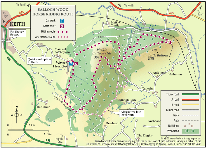
Permission: None required, Forestry Commission open access. There are several waymarked trails in this forest – maintained and created by the Balloch Riders Access Group.
Going: Mostly forest roads and tracks, sometimes stony, firm going on the open hill with some steep climbs.
Access points:
1. Small car park by road end and forest gate at Wester Herricks, grid ref NJ 458 495.
2. For a longer ride you can park on the old main road opposite the Keith Showground, NJ 434 499.
The highlight of a ride here is the ascent of the Meikle Balloch hill which, at 365m, has tremendous views to the north. The easiest way up is to follow the grassy track from the crossroads to the south at NJ464 474; this is the only route shown on the map.
Another, more interesting route, follows a small footpath which runs next to a gully starting on the east side 50m north of the forestry cross-roads at NJ 479 490. This is a little difficult to find, but the path is obvious once you are on it. You should avoid the two other paths that lead up from the west, including the waymarked path that goes straight up from the Herricks car park. These are steep and narrow and your horse’s hooves are likely to cause a lot of damage – both these routes are well used by walkers.
From the Keith showground, follow the path southeast through the trees, shortly after you join the stream, fork right and then cross a small burn beside the bridge. Just before the next footbridge follow a faint footpath up a very steep slope until you join the forest road in Dunnyduff wood. Again, keep off the newly built walkers path here which is easily damaged. After 400m fork right onto a ride and then cross a field to join the public road a few hundred yards from the Herricks carpark at Mains of Auchoynanie.
The summit of the hill is exposed and the cloud can come down quickly, so remember to take a warm coat and a carrot for Neddy.