Auchindachy and Mill of Towie Walks

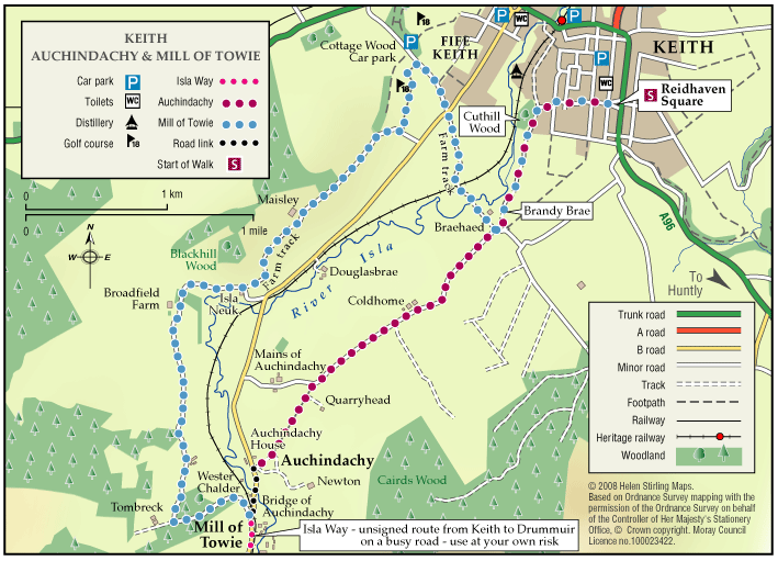
Both of these walks are part of a network of waymarked and signed paths around Keith. Straddling both sides of the valley of the River Isla, the routes venture from the town into the delightful open countryside to the south of the town. Ramble along the country lanes and take in the rich scenery and extensive views to the hills and mountains.

  • Unsuitable for wheelchairs and buggies
  • Terrain: Varied surfaces

    Both routes are mainly on tarred minor roads with some sections on farm tracks and grass/earth paths. Some sections can be muddy and overgrown at times, so sturdy footwear is advised.

  • Gradient: Undulating

    Generally undulating with a few steady gradients in places.

  • Barriers: Some barriers

    Several field gates along both routes and a narrow bridge with a step at Braehead (there is a ford along side which may be used by horses).

  • Fully signed

Balloch Wood and Hill

The Balloch forest covers about 2,500 acres and has a network of forest roads so a variety of routes are possible.  At the southwest end you can follow part of Governor Caulfeild’s military road, built about 1750, which ran from Stonehaven to Fochabers.

    Keith – Braehead and Cottage Wood

    This nature walk has an abundance of flowers, shrubs, trees and wildlife along the river and hedges set against a background of heather and tree clad hills.

    • Suitable for a wide range of users
    • Terrain: Varied surfaces

      A combination of tarred minor roads, aggregate paths and grassy tracks.

    • Undulating
    • Barriers: Some barriers

      Steps in two places (The Cottage Wood and the Auld Brig)

    • Fully signed

    Keith – Broomhill Circular

    This is a circular walk which includes Broomhill Cemetery. The route includes a beautiful tree lined path and a farm track, which can be quite exposed in bad weather. It is not suitable for wheelchairs or buggies. This route can join up with St Rufus Park Walk by turning right into the park off Broomhill Road.

    • Unsuitable for wheelchairs and buggies
    • Terrain: Varied surfaces

      A combination of roadside pavements, a tarmac footpath through the cemetery and a long section of gravel farm track. Take care on the track which is rather potholed and can be muddy in wet weather.

    • Gradient: Undulating

      Some gentle inclines.

    • Barriers: Some barriers

      Quite heavy gate at Broomhill cemetery.

    Keith – Cuthil Park Circular

    This is a circular walk round Keith, following the little lanes that criss-cross the town. The surfaces are suitable for wheelchairs and buggies and the route is fairly level apart from a steady climb from Turner Street to Cuthill Park. There are benches at the start and at Cuthil Park.

    • Accessible for all users
    • Paved footpaths & roads
    • Gradient: Undulating

      Steady climb from Turner St to Cuthil Park. Relatively level elsewhere.

    Keith – Denwell / Braehead Circuit

    The route can be enjoyed in both directions, starting and finishing at the map information board in Keith Square (Reidhaven Square). As parts of the route cross open countryside and have a variety of path surfaces, stout footwear and waterproof clothing are recommended.

    • Accessibility: Suitable for a wide range of users

      The minor road sections are suitable for people of a wide range of abilities.

    • Terrain: Varied surfaces

      A combination of rough grass paths and sections of minor tarred road.

    • Gradient: Generally level

      A few gentle gradients on the Brandy Brae path.

    • No barriers
    • Fully signed

    Keith – Dunnyduff and The Den

    This walk is part of a network of waymarked and signed paths linking all the delights the Keith area has to offer. The route can be enjoyed in both directions, starting and finishing at the map information board in Keith Square (Reidhaven Square). 

    • Accessibility: Unsuitable for wheelchairs and buggies

      Suitable for a wide range of users in the flat sections near Keith but in the countryside the route is appropriate for more able, energetic persons. Horse riding is not recommended at Tarnash due to the steep nature of the path linking to Dunnyduff.

    • Terrain: Varied surfaces

      A combination of roadside pavements, minor roads, green tracks and some rougher paths with several steep inclines.

    • Short steep sections
    • Barriers: Some barriers

      Some steps exist in Dunnyduff Wood.

    • Fully signed

    Keith – Fife Keith Park

    This is a pleasant circular walk, through town and woodland, including Cottage Wood. There are some long gradual slopes in the walk and the woodland paths need care, especially when wet. It is also fairly exposed in places and is not suitable for wheelchairs or buggies.

    • Unsuitable for wheelchairs and buggies
    • Terrain: Varied surfaces

      A mixture of tarmac pavements, bare earth woodland paths and a country road. Although reasonably quiet, please be vigilant of traffic on the road section.

    • Gradient: Undulating

      A few long gradual slopes.

    • Barriers: Some barriers

      Steps - located at entrance to Cottage Wood.

    Keith – Horse Market Circular

    This is a circular, level walk past fields of horses. There are benches in the Square and 1 along Edindiach Road. Pavements are good and the walk is suitable for wheelchairs and buggies.

    • Accessible for all users
    • Paved footpaths & roads
    • Generally level

    Keith – Kynoch Park Circular

    This is a circular walk linking Reidhaven Square to Keith Community Centre. There are benches in the Square and also at the Community Centre. Pavements are good and it is suitable for wheelchairs and buggies. This walk can be added to the Horse Market Circular to make a Level 3 walk of just over 2 miles.

    • Accessible for all users
    • Paved footpaths & roads
    • Gradient: Generally level

      Mainly level, but a gentle incline at School Road.

    • No barriers

    Keith – Simpson Memorial Park

    This is a circular walk which takes you round Simpson Memorial Park. It is mostly on pavements and good paths, apart from a short stretch of grass path which could be muddy in the wet. It is suitable for wheelchairs and buggies if dry and is fairly flat apart from the section along Drum Road.

    • Accessibility: Accessible for all with care

      Can be used by buggies and wheelchairs during dry weather.

    • Terrain: Varied surfaces

      Mostly on tarmac pavements and paths. Grass path at Simpson park - which can be muddy in wet weather.

    • Gradient: Undulating

      Long but steady climb up Drum Road. Relatively flat elsewhere.

    Keith – St Rufus Park Circular

    This circular walk includes some very interesting parts of Old Keith, Strathisla Distillery, Milton Tower and Keith and Dufftown Old Railway Station. There are some steep sections, which would make it unsuitable for wheelchairs. There are benches at the start and along the way.

    • Unsuitable for wheelchairs and buggies
    • Terrain: Varied surfaces

      A combination of roadside pavements, a tarmac footpath through the cemetery and a long section of gravel farm track. Take care on the track which is rather potholed and can be muddy in wet weather.

    • Undulating

    Keith – The Green Roadies

    Enjoy the many different species of flowers, shrubs and birds that can be identified. Marvel at the fine views of all the surrounding hills that can be seen across green fields and farmland.

    • Unsuitable for wheelchairs and buggies
    • Terrain: Varied surfaces

      A combination of tarred roadside paths, minor roads, aggregate paths and rough grassy tracks. The grassy track sections, although flat, are muddy in places and can be difficult to negotiate.

    • Gradient: Generally level

      A few gentle gradients in places.

    • Barriers: Some barriers

      Several gates at the cemetery.

    • Fully signed

    The Fishwives Route

    Follow the footsteps of the Fishwives. The Fishwives Path starts at the Buckie & District Fishing Heritage Centre where you will discover the unique fishing history of this lovely part of the Moray Firth.

    • Accessibility: Suitable for a wide range of users

      Suitable for more able and energetic walkers. The off road sections would be of interest to horse riders and mountain bikers.

    • Terrain: Varied surfaces

      Nearly two thirds of the route is along tarmac roads and paths which are easy to negotiate. The rest is on farm/forestry tracks and grassy paths; the surface in places is rough and uneven and can be muddy in wet weather.

    • Gradient: Gentle gradients

      The route climbs from the sea at Buckie to around 270 metres (900ft) above sea level. From both the Keith and Buckie ends the path rises gradually to the highest point at Addie Hill.

    • Barriers: Some barriers

      Gates

    • Fully signed

    The Isla Way

    This 13 mile route has a great variety in scenery and setting, and you will always be rewarded with natural beauty wherever you are on the path. The route follows the valley of the infant River Isla, which rises in the hills above Drummuir on its way to Keith and the Moray Coast beyond.

    • Accessibility: Unsuitable for wheelchairs and buggies

      All of the route can be used for walking, cycling, and horseriding.

    • Terrain: Varied surfaces

      Surfaces are generally sound including tar, gravel and earth paths. In places the trail follows narrow tarmac public roads, and road pavements through Dufftown and Keith. Sections of the paths will be muddy when wet.

    • Gradient: Undulating

      The route climbs to around 300 metres (1,000ft) above sea level. Total height climbed is modest at around 240 metres (780 ft). Slopes are generally easy, although there are a couple of steep sections to be negotiated.

    • Barriers: Many barriers

      Between Dufftown and Loch Park there is a narrow suspension bridge across the River Fiddoch. There are some steps in the Toon Widd at Dufftown.Loch Park to Drummuir has no barriers and is an all abilities standard.Between Drummuir and Keith there are unsigned sections on public roads, including a mile section on busy B9014, where users are next to fast traffic.Two field gates exist across the path above Auchindachy.

    • Partly signed