Ben Aigan and Knockmore
This ride takes you to the transmitter on Knockmore, the summit of Ben Aigan and stunning views of Speyside. The route described is not way-marked by the Forestry Commission as a horse-riding trail.
- Horse Ride
- 10 miles (16 km)
- Rothes
Terrain: Varied surfaces
Mostly forest roads, some open moorland and one steep grassy track. The climb to the summit is very stony.
- Mixed gradient
Report a route change
If you have followed this route and noticed any differences please report a route change by sending an email to:
Send us a GPX track
We would like to offer GPS tracks of all routes on this site.
If you are able to help please create a GPX track of this route (no detours) and send it to us for inclusion.
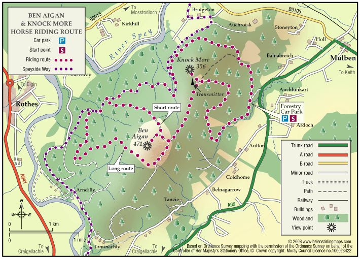
Access point: Forestry car-park just off the A95 at grid ref NJ 334494 – signposted on main road.
Ben Aigan is best known locally as the hill with the big TV transmitter on the subsidiary summit of Knockmore. The forestry roads and tracks provide a varied circular route that will take you about three hours and to the summit of one of the highest hills in the area.
Ben Aigan is now a major venue for mountain biking with new single purpose built ‘single track’ bike routes having been built in recent years. To avoid fast mountain bikers and damage to their new trails, please do not ride on the waymarked cycle routes except where these follow the forest
roads.
From the car park head south along the forest road which steadily climbs and turns in all directions until you reach the transmitter. For a tremendous view to the north, go about 150 yards past the transmitter on a faint track to an area of open ground just beyond a smaller tower.
Go back to the transmitter and follow the land rover track that leads downhill and then uphill, becoming muddier when you enter the large open area around the summit of Ben Aigan. Here you have two options at the junction.
1 Turn right and climb gently. After a few hundred yards you can take the stony track on your left which leads up to the summit. Return the same way to this point and turn left. The track will take you steeply downhill, crossing the mountain bike route. Turn right onto the forest road. This is the shorter route
2 For a longer route continue straight on along this path, bearing right when you rejoin the trees and you then start to descend steeply on a narrow track. Follow the steepening track downhill, enjoying the view up the Spey, but try to avoid falling into the ruts! You pass into an area of taller
trees then suddenly rejoin a forest road. Turn right, and after a mile keep right at the junction, and after a few hundred yards the other route rejoins on your right.
Stay on this forest road which undulates and twists around quite a lot. Look out for the viewpoint, on the left (signposted), which is an ideal spot for a picnic with views northwards up the Spey to the coast. Keep on the forest road for the next four miles back to the car park, ignoring the Speyside Way which forks off to your left.
Most cyclists treat us courteously as we treat them, but in case some aren’t used to passing horses, it would be a good idea wear your ‘please pass wide and slow’ tabard if you have one.
The forestry is very sheltered, but the top of the hill is high and exposed so take a warm coat.
Permission: None required, Forestry Commission open access.