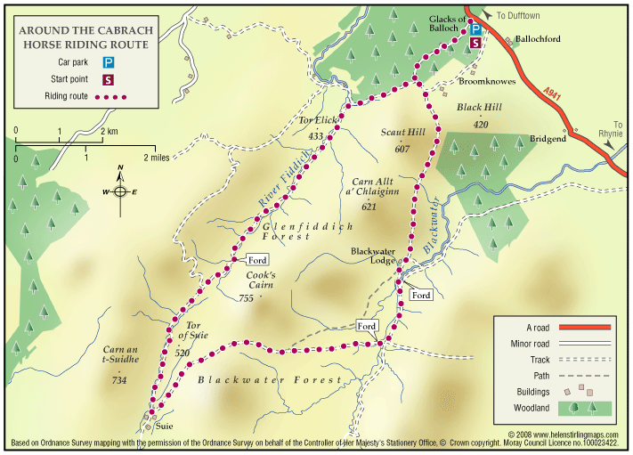
Cabrach
This is a pleasant and scenic all day ride across open moorland with some good views from the slopes of Cook’s Cairn. Quite a bit of wildlife to see including large herds of deer.
- Horse Ride
- 18 miles (28.8 km)
- Cabrach
Terrain: Varied surfaces
Some good estate tracks suitable for fast trotting; the higher moorland tracks are rougher and more stony.
Report a route change
If you have followed this route and noticed any differences please report a route change by sending an email to:
Send us a GPX track
We would like to offer GPS tracks of all routes on this site.
If you are able to help please create a GPX track of this route (no detours) and send it to us for inclusion.
Caution: This is quite remote countryside and you climb to nearly 600m so check the weather forecast and take spare clothing as well as a packed lunch. The Cabrach Estate is used for deerstalking and grouse shooting so you should avoid the eastern track past Blackwater Lodge during the shooting season as this is not a right of way. (There is no shooting on Sundays).
Access & Parking: There is a small parking space at the end of the forest road where it joins the A941 Dufftown – Rhynie road at grid reference NJ 352342. There are also two lay-bys a couple of hundred yards north on the public road.
Follow the forest road and pass through a narrow gate into the forest and continue uphill. Turn left at the junction and then through a gate, (which is probably open) and continue downhill to another gate onto open moorland. Turn left onto the estate road and after one mile bear right at the fork.
Continue on to Blackwater Lodge. This section of the route has the best surface so it is worth trotting on as much of the rest of the route is stony enough that you will probably want to walk most of it.
Immediately after the lodge, which is ruined, bear left and follow the track across the river and continue southwards for one mile. At the staggered cross-roads turn right, ford the stream again and start the long climb up over Blackwater Forest and the shoulder of Cook’s Cairn. The descent on the far side is steep and stony in places. This track is known as the Steplar Road and is an ancient right of way.
The ruins at Suie are a good spot for lunch as you can tie the horses up to the fence posts and there may even be some grass. Retrace your steps northwards for a hundred yards and bear left onto a narrow and rougher land-rover track. Stay on this track for the next five miles, ignoring the track on your left after a couple of miles. This undulates a bit, crosses the burn several times and takes you through an attractive ravine.
Eventually you come to a junction * by a plantation of large pine trees. Turn right here, climb steadily uphill for a mile then at the quarry turn left, pass pass through the gate, and return along your outward route.
* The right of way continues to the left here and follows the track beside the Fiddich to the main road.