Cullen – Salmon Bothy Circular
The Salmon Bothy Circular Path provides a short coastal walk, which takes in magnificent coastal views.
- Low Level Walk
- Easy
- 1.6 miles (2.56 km)
- 40 meters (131 ft)
- 45 minutes
- Cullen
Accessibility: Unsuitable for wheelchairs and buggies
There is a steep ramped path with handrail leading from the harbour area up to cliff top. Flat gravel path between the caravan park and the Nelson’s Seat viewpoint providing opportunity for less able bodied users.
Terrain: Varied surfaces
Fully surfaced roadside paths in the built up areas. Bound gravel paths elsewhere, with a short steep section of rough grassy path at the outlying gully. There are plans for this section to be upgraded to gravel.
Gradient: Mixed gradient
Relatively flat throughout but there are two short steep sections.
- Fully signed
Report a route change
If you have followed this route and noticed any differences please report a route change by sending an email to:
Send us a GPX track
We would like to offer GPS tracks of all routes on this site.
If you are able to help please create a GPX track of this route (no detours) and send it to us for inclusion.
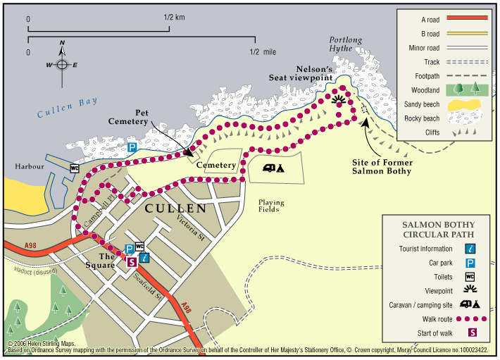
This path is part of a network of promoted paths, which start and finish at Cullen Square where there is a map board and plenty of parking. The routes are centred around the pretty fishing village of Cullen, and it’s surrounding countryside. The rugged skerries, cliffs and coves of the Moray Firth provide a dramatic setting for this historic town, making Cullen not only an attraction for visitors, but also a haven for many species of marine wildlife and seabirds.
The route starts at The Square. Head north down Seafield Street to the Harbour, from here travel along Portlond Road: the pet cemetery is on your right. A little further on a barrier blocks the way to vehicles. Walk round this and continue to Portlong Hythe, staying on the path around the headland until you reach the site of the former Salmon Bothy. There is only the old launching ramp there now. From here take the winding grass path leading to the foot of the gully, and then follow the steep gravel path up the hill. At the top, to your right, there is a separate path leading to the viewpoint at Nelson’s Seat. There is a bench here for taking in the splendid coastal views. Return to the main gravel path, and follow it along the edge of the Caravan Park to its end, and then turn right into Seaview Place. Walking straight ahead- with the cemetery on your right, and a group of timber garages on your left- continue downwards past the Fire Station. Continue along and turn right into Lower Blantyre Street, going to the end where it meets the cliff top overlooking the harbour. A small park area allows another chance to take a seat and enjoy the views. Continue along the tarred path and take the formal ramped pathway down the road below. Turn left at the bottom and head back up Seafield Street to your start point at The Square.
History
The path is named after the former Salmon Bothy, which was used by fishermen up to 1975. During the summer nets- marked by buoys- would be left overnight in the sea, and in the morning the cobles would be rowed out to bring in the catch.
Views
The path provides panoramic views across Cullen Bay to the hills of Caithness and Sutherland over sixty miles away. You may also be lucky and spot the dolphins frisking in the Firth.