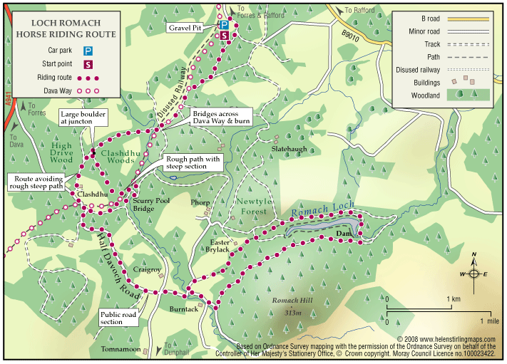
Loch Romach and Altyre Estate
Views across the Cromarty Firth are magnificent from the High Drive on Altyre Estate. Some of this route follows the Dava Way which is way-marked but much is on private land.
- Horse Ride
- 7 miles (11.2 km)
- Forres
Report a route change
If you have followed this route and noticed any differences please report a route change by sending an email to:
Send us a GPX track
We would like to offer GPS tracks of all routes on this site.
If you are able to help please create a GPX track of this route (no detours) and send it to us for inclusion.
*Please note we have been informed that the Forestry Gate near Burntach Cottage does not make provision to get a large horse through the access points. It may be possible for a small pony. We will follow this up with the Forestry Commission.
Views of the loch are limited until the halfway spot (where there is a good, flat area beside the Dam to corral horses for a lunch stop and a swim in the loch !) Views across the Cromarty Firth are magnificent from the High Drive on Altyre Estate. Some of this route follows the Dava Way which is way-marked but much is on private land. There is no way-marking on the private land and the routes described are not specifically maintained for public access.
Location. Forestry land and estate tracks south of Forres.
Distance: approx 7 miles out and back.
Going: Takes approx. 3 hours out and 3 hours back, so a long day in the summer. Beautiful mixed forest, mostly flat with a few steep but short slopes down onto the old railway which is now the Dava Way and up from it again. The ground is for the most part soft forest track but with a quiet road section of a mile and a half or so and the final track beside the loch which is stonier.
Access and Parking: Park at the gravel pit in Newtyle forest (map ref : NJ 053 552)
Follow the forestry tracks to “forestry cottages” (NJ 051 542) and on to Scurry Pool bridge (NJ 043 535).
Cross bridge and head up along “High Drive Wood” look for tracks leading off to the left and take the second track (large boulder on the left as you turn left) into Clashdhu Wood and at the end of the track wind your way down onto the old railway line (there is a rough and overgrown path which leads down a steep slope onto the railway line).
Turn left along the old railway, then take a right up track which turns uphill and back on itself, running parallel to the old railway, a good track for a long canter through Annie Paul’s Wood, it ends at the Half Davoch Road, just where the railway meets it (NJ 031 525) from here turn left and ride up the Half Davoch Road until the fork to the left at Craigroy Cottage (just off the map)
Continue past Craigroy Cottage and on to Brylack (NJ 052 513) and from here follow the forestry paths (Newtyle Forest again) around the north side of the loch, stopping at the Dam, before continuing around the south side of the loch and back to the Half Davoch Road. The route home can be shortened slightly by continuing along the Half Davoch Road, past the railway junction until the right turn, up towards Clashdhu house. This continues onto High Drive Wood and from here follow the same route home.