The Dava Way
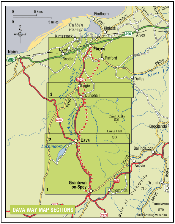
The Dava Way is a 23 mile trail across the ancient Celtic province of Morayshire between the historic towns of Forres and Grantown-on-Spey. The route links Strathspey and the Cairngorms National Park with the Moray Coast in North East Scotland. Almost all of the route follows the old Highland Railway line and is off road and safe from traffic.
- Long Distance Walk
- Challenging
- 23 miles (36.8 km)
- 12 hour(s)
- Forres, Grantown-on-Spey, Rafford
Accessibility: Suitable for a wide range of users
WALKING - The surface is varied, mostly firm and good, but it can be wet and rough in places. All of it is fine for walking. CYCLING - The Dava Way can be used as an ‘off road’ cycling route, as most of it is over a firm but rough surface.
Terrain: Varied surfaces
The surface of the path is generally compacted track-bed material, rough and rutted in places, and is good for walking and 'off-road’ cycling. Depending on the weather, stretches may be wet but the Dava Way Volunteers have installed new drains and this has improved the paths.
Gradient: Gentle gradients
The route has a very gradual gradient which rises on the Dava Moor to 320m (1050ft) above sea level at its highest point.
- Fully signed
Report a route change
If you have followed this route and noticed any differences please report a route change by sending an email to:
Gallery
The Dava Way passes through a pleasing mix of farmland, woodland and moorland as you climb from the Spey Valley to cross Dava Moor before descending to the Moray Firth. As you cross the moor on a clear day you are rewarded with views to the south over the shire counties of Nairn, Inverness, Moray, Ross & Cromarty, and Sutherland, whilst to the south the Cromdale Hills and Cairngorm Mountains dominate the skyline.
The route was opened as a long distance path in 2005 by the Dava Way Association- a voluntary organisation set up to develop the route. It continues to be developed and maintained by this group’s dedicated members.
This is a pleasant and easy route with a variety of landscape, flora and fauna, along with natural and railway heritage.
For detail maps of the route click on the following:
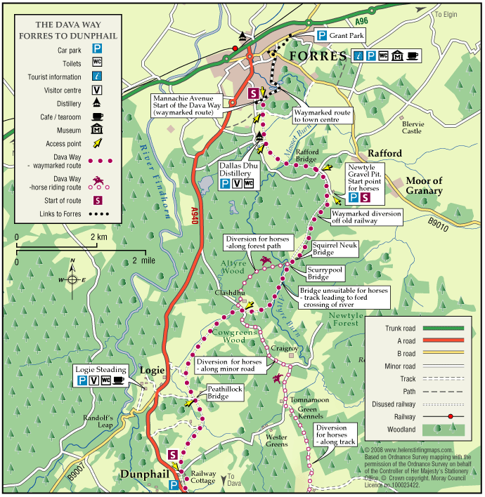
Starting your journey from Forres; the Dava Way begins at Mannachie Avenue approximately a mile from the town centre. A network of sign posted paths through the woodlands surrounding Forres, from Grant Park and Sanqhuar Pond lead to the old railway and the start of the Dava Way. (Refer to ‘Forres Town Centre Map’ in the Useful Downloads section at the bottom of this page, for route directions through the town.)
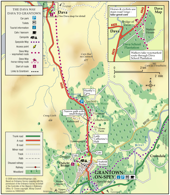
Starting from Granton-on-Spey town centre, take the road leading towards the camping and caravan park.
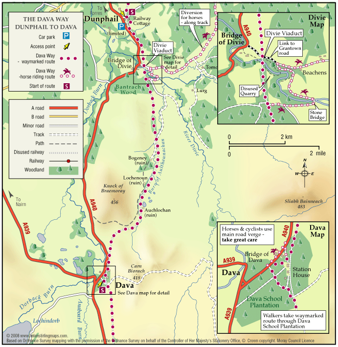
The route can also be joined at various points along its length, including Dunphail and at Dava although there is only limited parking.
The route passes through a number of sporting estates. The shooting season runs almost throughout the year. You can minimise disturbance by being alert to the possibility of shooting taking place and taking account of advice on alternative routes. Avoid crossing land where a shoot is taking place until it is safe to do so.
The Dava Way is generally a wild environment. As a result take the appropriate clothing and footwear before setting out, and prepare for changing weather on the upland sections. A midge repellent is recommended in summer months. Wild and domestic animals may also be encountered, so please keep your dog under control or on a short lead.
Although the path is never far from the Grantown-on Spey to Forres road, there is no public transport and no places for refreshment throughout the length of the route. You are advised to take food and water if you plan to walk or cycle long sections or all of the route.
The path is directed away from the railway at four locations. Three diversions are to avoid private property, and the other is to avoid a flooded section. These are clearly signposted.
WALKING – The surface is varied, mostly firm and good, but it can be wet and rough in places. All of it is fine for walking. Fit walkers can complete the route in a day but most will want to break it into 2 or 3 stages (refer to the Dava Way website for detailed route descriptions)
There are opportunities for circular walks but none have been waymarked as yet.
CYCLING – The Dava Way can be used as an ‘off road’ cycling route, as most of it is over a firm but rough surface.