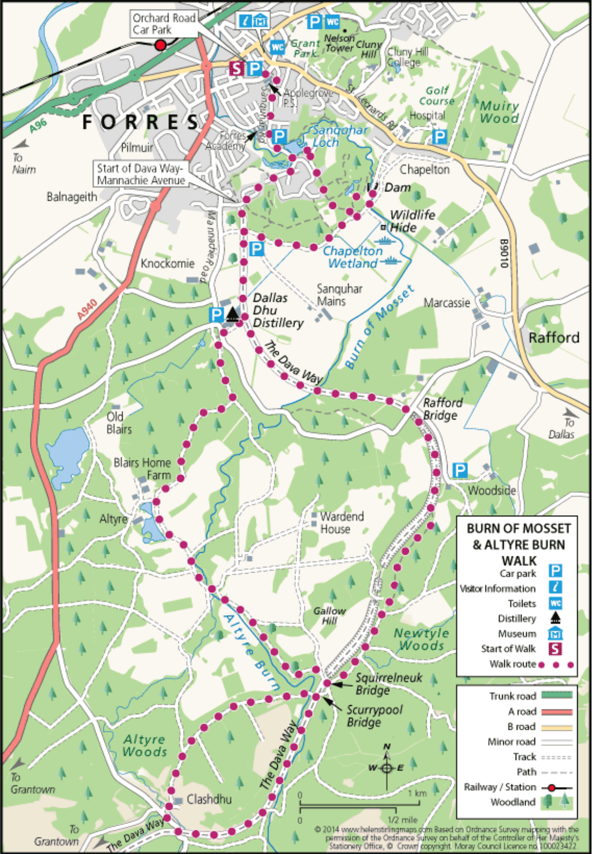
Forres – Burn of Mosset & Altyre Burn
This circular walk explores the Burn o Mosset as it starts to flow through Forres and then takes you to the earlier stages of the stream which starts as the Altyre Burn. The route uses the Dava Way to head South from Forres before returning through forestry estates with good views at several stages of the walk. The walk can be shortened to 8 miles by starting at the Dallas Dhu distillery.
- Low Level Walk
- Moderate
- 11 miles (17.6 km)
- Forres
- Suitable for a wide range of users
- Varied surfaces
- Unsigned
Report a route change
If you have followed this route and noticed any differences please report a route change by sending an email to:
Send us a GPX track
We would like to offer GPS tracks of all routes on this site.
If you are able to help please create a GPX track of this route (no detours) and send it to us for inclusion.
The Outward route is way marked by Forres Footpaths Trust (FFT) Yellow and Purple arrows and Dava Way signposts as described but there are no way marks on the return route until back at the Dallas Dhu distillery.
Timber operations may restrict access at times and tree growth and timber extraction can change the walking environment from that described.
During the shooting season from October to February, walkers must be prepared to divert from the described route to avoid shooting parties which form an essential part of the rural economy. Walkers are responsible for their own navigation and use of the tracks and footpaths under the Scottish Outdoor Access Code.
Planning Start/Parking Orchard Road Car Park Grid Ref: NJ038588 Map OS Landranger 27 or Explorer 423
Refreshments Various in Forres Public Toilets Various in Forres Public Transport Buses from Inverness/ Aberdeen to Forres Trains from Inverness/ Aberdeen to Forres right in the middle of which is a stand of Scots pine. Here was once situated the Sanquhar Estate Offices.
The path starts to drop gently downhill and you turn Left onto another track following the Yellow arrow. This track climbs and then descends. Shortly you turn Right at a Yellow arrow onto a narrower but distinct path. This path will take you to a wonderful view over the Burn of Mosset dam with long distance views to the South. Walk down onto the dam which is part of a £20 million flood prevention scheme that restricts the water flow down the Mosset Burn into Forres: the fields upstream of the dam will flood instead.
The dam’s construction and the water flow restriction can be seen from the wooden bridge upstream of the dam. Leave the bridge with the water flowing into the dam on your left and pass the end of metal gates onto a wide track. If you wish to visit the Chapelton Wetlands Wildlife Hide turn left before these metal gates and follow the track that runs beside the stream for about 100 metres and you will see the Wildlife Hide in front of you. After looking out over the wetlands created as part of the flood alleviation scheme, retrace your steps to re-join the walk. Ignore the track off to your right and continue along this track with fields on your left and woodland on your right. You will pass a mountain bike jump area on your right: the woodlands have marked MTB tracks. The Walk The walk starts from the Orchard Road Car Park. Leave the car park at the Applegrove Primary School end, cross Orchard Road with care and take the footpath that runs along the left side of the school. At the end of the footpath turn Right and continue along Sanquhar Road passing Roysvale Park on your Right. Sanquhar Road curves left with Forres Academy on your right and you soon come to a small car park on your left where there is a FFT information point. You are at the beautiful Sanquhar Pond, which is fed by the Burn o’Mosset and was created in 1900 to supply cooling water to Benromach Distillery. A Fish Ladder is on the opposite side of the road. Continue along the road until the end of the embankment and turn Left following the Yellow FFT way marks onto a narrow track leading up through woods, with properties on your right.
Continue to follow the Yellow way marks as the path curves right at the top of the slope and then joins a wider path. Follow this path crossing a tarmac road at Woodend. Here note the older property on your right which was once the gardener’s cottage when this area was part of the Sanquhar Estate. Here you enter Sanquhar Woodlands now managed by the Forres Community Woodlands Trust. Continue following the Yellow FFT arrows along the path and you will see an open space on the Shortly after passing a lower level parking area turn Right following a FFT Purple arrow as you join a well surfaced track and leave the woods. You will soon see some low walls which are part of the bridge taking the road over what used to be the main railway line from Inverness to Perth from 1863 to around 1898, when the current main line over Slocht Summit was opened. This line was used by troop trains during both WW1 and WW2 and continued in service until 18th October 1965, when the passenger service stopped. At the bridge follow the FFT Purple arrow and take the steps on the right down onto the old track bed, which is now part of the Dava Way. At the bottom turn Left under the bridge to join the Dava Way which you follow for the next 4 miles. You soon pass the Dallas Dhu Historic Distillery and those who wish a shorter (8 mile) circular walk could park and start from here. Ignore the Purple FFT arrows that would take you down past the Distillery. Views open up on the left side and you cross the Burn of Mosset, far below, as it passes under the old railway track. A delightful stretch through woodland takes you past a large area on the left where Rafford Station once stood: the wooden station was only used for the first 20 years of the line. Ignore the signposts to Rafford and continue along the Dava Way soon crossing over a minor road on a bridge. The path then runs on the Rafford Embankment and the lower part of the village of that name, the Church and Blervie Castle can be seen off to the left with the Califer Hills in the background.
Follow the Dava Way Grantown signs as you divert Left off the old railway track to avoid an overgrown cutting: for about 2 miles you will follow clearly marked tracks through the forest running almost parallel to the old railway. After some uphill and downhill sections, the Way emerges from the trees onto a wide forestry track with a forester’s cottage on the left, passes to the left of wide metal gates and climbs uphill. At the top follow the Dava Way as it bears Right and very soon a seat will appear on your left with a surprising view out over the Moray Firth and into the mouth of the Cromarty Firth on a clear day. This view has been created accidentally by trees being blown over in high winds. The Way now descends down to Squirrel Neuk bridge where you turn Right to cross the bridge and then immediately Left to re-join the old railway track by descending a series of steps signposted Dava Way Grantown. Look to your left at the amazing brickwork of the underside of the bridge. visibility is very good, you can see Morven about 60 miles away across the Firth and Ben Wyvis beyond the Black Isle. Follow the forestry track without deviating left or right and it will curve downhill with a delightful area opening up on your left as you see again the Altyre Burn in a large loop. You now cross over the Scurry Pool bridge admiring the small castellations which you can step into and have views down below onto the Burn and the disused railway track. Continue along between high rhododendron bushes and you arrive back at the Dava Way having completed the Southern loop. Cross over Squirrel Neuk bridge again but this time continue along the track and, in about 100 yards, take the green track to your Left and you now follow the Altyre Burn flowing down through the woods. Another track will come in from the Right but continue straight ahead passing an old, ivy covered tower on your right which apparently provided a high up viewing area over the surYou are now starting on the 2.6 mile Southern Circular Loop of the Walk. The Altyre Burn which you crossed earlier as the Burn of Mossett runs delightfully on your right. The Way takes you under Scurry Pool bridge, a grade 2 monument, which crosses both the railway and the Burn. A picnic bench, seat and descriptive board are down to your right and provide a delightful spot for a picnic beside the waterfall. Continue onwards on the Dava Way crossing the metal bridge gifted to the Dava Way Association by A J Engineering of Forres. The provision of this bridge marked a significant point in the creation of the Dava Way. You continue South along the Dava Way bidding goodbye to the Altyre Burn as it turns away where a wide forestry track comes in from the left. Stay on the disused rail track and you soon reach the metalled, minor road to Half Davoch and here, at the half way point of the walk, you leave the Dava Way. Turn Right along the minor road for some 200 yards and just before the road goes over a bridge across a stream turn Right onto a track with an electric pole on your right. Follow the track as it curves Left uphill having crossed a small stream – do not go up to the farm. This forestry track soon opens out on the left with views over young trees to Forres and Findhorn Bay in the distance and, as you walk, more and more of the inner Moray Firth comes into view. If the rounding countryside: the outside access steps are no longer there. Shortly afterwards on the right is an old ice skating rink which now has a smaller area used in winter for Curling. At the end of the track turn Left onto a metalled road and cross the wooden bridge over the Altyre Burn and then follow this metalled road around to the Right as it follows the Burn. Keep Left on the main metalled road where another road goes off to the right – you are saying a final goodbye to the Altyre Burn at this point.
Continue along the metalled road. Through the trees, ponds and Altyre House will come into view on your left. At the T junction turn Right off the metalled road onto a wide track and, as you turn, you can see large Italianate farm buildings. These were originally farm buildings but after restoration are a campus of the Glasgow School of Art. Follow the track past the estate cottages on your left, turning Left after the last building in the row which in earlier times was the estate school. Continue along this track into the forest until you reach a T junction. Turn Left onto a lesser used but partially metalled road which becomes narrow in parts due to overgrowing broom. As the pagoda style ventilator of Dallas Dhu distillery comes into view on your Right, look for a clear path that climbs up off the track towards the distillery. Take this path and, with great care, cross the minor road before turning into the distillery entrance and walking down through the car park to the small gate giving access to the Dava Way. Walk up onto the embankment turning Left towards Forres. You have walked just over 8 miles since you passed this spot on your outbound leg. Follow the Dava Way as it crosses a hump that is part of the Forres flood alleviation scheme, pass under the bridge and continue into the cutting. Follow the Dava Way signs as you leave the old railway track climbing up the access ramp on the right hand side. At the top turn Right following the Dava Way sign to pass through the houses of Mannachie Rise. Ignore the road off to your left but as the road curves around to the left, turn Right up a wide driveway towards more houses and a footpath with Dava Way sign will lead you through into Loch View. Continue straight ahead along Loch View and it will lead you down a slope to curve left and become Sanquhar Road passing Sanquhar pond on your right. Continue along Sanquhar Road back to the Orchard Road car park.