Archiestown – Cairn Cattoch

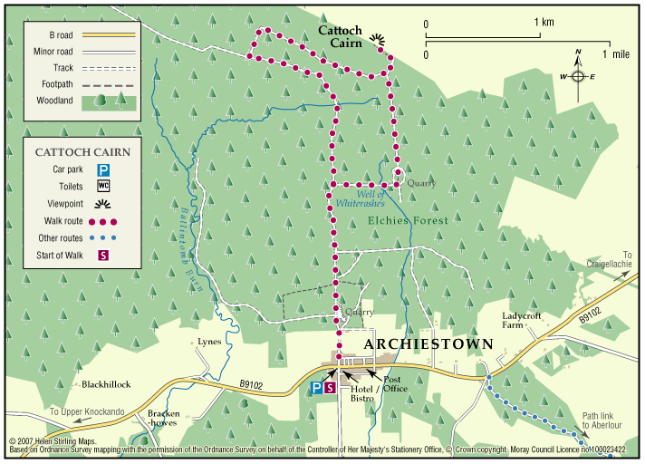
Cairn Cattoch Walk is one of several waymarked walks within the forest to the north of Archiestown.

  • Accessibility: Suitable for a wide range of users

    The route is suitable for a wide range of users, although cyclists may require to dismount on the short section to the viewpoint

  • Terrain: Forest tracks

    Mainly on forest track. There is a short section of rough earth path through heather to reach the summit viewpoint. Stout footwear is advised

  • Gradient: Mixed gradient

    Long gentle climb along most of route, with a steeper section leading to the viewpoint. A total climb of 130 metres (390ft) with the summit sitting at 369 metres (1120ft) above sea level

  • No barriers
  • Fully signed

Auchindachy and Mill of Towie Walks

Both of these walks are part of a network of waymarked and signed paths around Keith. Straddling both sides of the valley of the River Isla, the routes venture from the town into the delightful open countryside to the south of the town. Ramble along the country lanes and take in the rich scenery and extensive views to the hills and mountains.

  • Unsuitable for wheelchairs and buggies
  • Terrain: Varied surfaces

    Both routes are mainly on tarred minor roads with some sections on farm tracks and grass/earth paths. Some sections can be muddy and overgrown at times, so sturdy footwear is advised.

  • Gradient: Undulating

    Generally undulating with a few steady gradients in places.

  • Barriers: Some barriers

    Several field gates along both routes and a narrow bridge with a step at Braehead (there is a ford along side which may be used by horses).

  • Fully signed

Ben Aigan

Ben Aigan lies to the east of Rothes, the north east of Craigellachie and to the east of the River Spey which flows along the foot of its western and northern slopes. Rising to a height of 471m (1546 feet) and extensively forested apart from the summit cone, the top of Ben Aigan provides magnificent views over Speyside, south to Ben Rinnes, and away to the north over the Moray Firth to the hills of Sutherland

  • Unsuitable for wheelchairs and buggies
  • Defined hill path
  • Slopes throughout
  • Partly signed

Ben Rinnes

Ben Rinnes is the highest freestanding mountain in Moray at 2733ft (841 metres), and is classified as a ‘Corbett’ – a summit lying between 2500ft and 2999ft. 

  • Unsuitable for wheelchairs and buggies
  • Defined hill path
  • Slopes throughout
  • Unsigned

Buckie – Gollachy Circular

This route explores the coast west of Buckie as far as the village of Portgordon, returning at a higher level with extensive views over the Moray Firth.

  • Accessible for all users
  • Terrain: Varied surfaces

    Tarred pavements and gravel paths. A short section of earth path at Gollachy Burn can be muddy.

  • Gradient: Short steep sections

    Short steep section climbing up to the golf course near the Gollachy Burn

  • Fully signed

Buckie – Laird’s Way to Drybridge

The peaceful village of Drybridge sits above Buckie surrrounded by woods and farmland. Follow the way from Buckie over the Buckie Burn and past the distillery. On the way to Drybridge you will be rewarded with fine views over farmland and beyond to the Firth.

  • Fully signed

Burghead – Clarkly Hill Circular

A circular walk starting in the Pictish Fort town of Burghead and passing through farmland and rocky shores, with stunning views of the Moray Firth along the ridge of Clarkly Hill.

  • Unsuitable for wheelchairs and buggies
  • Terrain: Varied surfaces

    Tarred pavements & roads, gravel paths, and earth/grass paths along the Clarkly Hill sections. Note: the earth paths are rough and uneven in places and can be muddy.

  • Gradient: Generally level

    A gentle slope rising from the Burghead - Lossiemouth road to Clarkly Hill

  • Fully signed

Corryhabbie Hill & Cook’s Cairn

Corryhabbie is the highest point of the long moorland ridge between Glen Rinnes and the heads of Glenfiddich and Glenlivet. From the plateau-like summit there are extensive views over vast rolling hills and moors to the Cairngorms to the south and Ben Rinnes to the north.

  • Unsuitable for wheelchairs and buggies
  • Defined hill path
  • Slopes throughout

Dufftown – Dufftown Dramble

‘Rome was built on seven hills, Dufftown was built on seven stills’ – so goes the old rhyme. This walk, starting from the Dufftown clock-tower, links all the Dufftown distilleries in one walk.

  • Accessibility: Suitable for a wide range of users

    Able-bodied walkers, some sections can be cycled. The nature of the terrain and the presence of physical barriers would make the route difficult to negotiate on horseback.

  • Terrain: Varied surfaces

    A mixture of tarmac, gravel and grass paths with some sections on public roads - look out for traffic. Short gradients and sections of uneven path.

  • Gradient: Undulating

    Generally level with short gradients.

  • Barriers: Some barriers

    A number of gates and steps.

  • Unsigned

Dufftown – Gordon’s Cross

The Gordons Cross Path explores the countryside around Dufftown and gives good access to all the natural attributes the area has to offer throughout the four seasons.

  • Accessibility: Suitable for a wide range of users

    The section of route between Hardhaugh and the Crachie Road Bridge is not recommended for horses or cyclists due to the nature of the route surface and the presence of physical barriers.

  • Terrain: Varied surfaces

    Fully surfaced roadside paths in the build up areas. Rough grassy and gravel paths in country sections.

  • Gradient: Short steep sections

    A total climb of 250 feet involved in traversing this route. Gentle inclines throughout but there are a few short steep sections.

  • Barriers: Some barriers

    Several gates require to be negotiated near Gordon’s Cross and beside the River Fiddich where there are also wooden steps.

  • Fully signed

Dufftown – The Convals

The Convals (Meikle Conval, 571m and Little Conval, 552m) are the two ’rounded humps’ separated from Ben Rinnes by the ‘Beatshach’, the pass linking Speyside to Glen Rinnes.

    Dufftown – The Viking Trail

    The Viking Trail has two routes to follow one approximately five miles long the other being much longer at twelve miles.

    • Unsuitable for wheelchairs and buggies
    • Mixed gradient

    Dufftown- The Giant’s Chair

    The ‘Giant’s Chair’ is a rock feature carved out by the power of the River Dullan in spate. This lovely walk takes in many interesting features of history, culture and landscape. Dufftown has seven operating whisky distilleries including the famous Glenfiddich brand.

    • Accessibility: Suitable for a wide range of users

      The route is suitable for walkers and mountain bikes.

    • Terrain: Varied surfaces

      Mixture of tarmac, gravel and grass. Some rough sections near The Giant's Chair.

    • Gradient: Undulating

      An undulating path with some short steep sections. Total height climbed is around 200ft (60 metres).

    • Barriers: Some barriers

      Kissing gate at far end of this walk, and some flights of steps

    • Fully signed

    Forres – Burn of Mosset & Altyre Burn

    This circular walk explores the Burn o Mosset as it starts to flow through Forres and then takes you to the earlier stages of the stream which starts as the Altyre Burn. The route uses the Dava Way to head South from Forres before returning through forestry estates with good views at several stages of the walk. The walk can be shortened to 8 miles by starting at the Dallas Dhu distillery.

    • Suitable for a wide range of users
    • Varied surfaces
    • Unsigned

    Forres – Califer Hill & Rafford

    A circular walk along minor roads and footpaths with stunning views from Califer Viewpoint, returning via lower Rafford and the Dava Way with a shorter route option from Rafford Church available.

    • Suitable for a wide range of users
    • Terrain: Varied surfaces

      Minor Roads, Grassy Lanes, Farm Tracks, Footpaths, Woodland Tracks, some potentially muddy and slippy parts following wet weather and some narrower sections.

    • Gradient: Generally level

      Most of this route is relatively level with the steepest section being the ascent and descent to and from Califer Hill Viewpoint.  The viewpoint ascends to 184.5m.

    • Barriers:

      There are footbridges to cross and some narrower sections.

    • Unsigned

    Forres – Dyke & Kintessack Circular

    A circular route linking the rural communities of Dyke and Kintessack, with a spur to Broom of Moy, and on to the wider network of paths around Forres.

    • Unsuitable for wheelchairs and buggies
    • Terrain: Varied surfaces

      Minor tarmac roads, forest tracks, earth paths, and short sections of gravel paths. NOTE: In the winter a short section of the path between Dyke and Culbin Forest (at Loanhead) can be very wet. Waterproof boots or wellingtons are advised.

    • Generally level
    • Barriers: Some barriers

      Bridge with steps located at Wellhead.

    • Fully signed

    Forres – Engineering Past and Present

    An interesting and varied circular walk on the outskirts of Forres which visits some of the engineering projects that have changed the local landscape from the 19th century to the present day.

    • Suitable for a wide range of users
    • Terrain: Varied surfaces

      Mixture of tarmacked paths, stepped sections, woodland tracks and earth paths with some undulating sections.

    • Generally level
    • Barriers: Some barriers

      There are a few stepped sections and two wooden bridge crossings over the Burn o' Mosset.

    • Unsigned

    Forres – Mosset Walk

    A circular walk around Forres, taking in the picturesque Sanquhar Loch, the panoramic view from the Nelson Tower at the top of Cluny Hill and a fine view of the town from Councillor’s Walk. 

    • Unsuitable for wheelchairs and buggies
    • Terrain: Paved footpaths & roads

      Take care on the two A96 road crossings.

    • Gradient: Short steep sections

      A fairly steep path within Grant Park leading up to Nelson Tower. Otherwise, generally level with only a few gentle slopes.

    • Barriers: Some barriers

      Kissing Gates (2), and steps.

    • Fully signed

    Forres – River Findhorn Circular

    A circular walk through and around the town of Forres, following the banks of the River Findhorn for much of the route. With some fine views of the surrounding countryside it explores some attractive, yet less frequented, environs of this pretty Moray town.

    • Accessibility: Unsuitable for wheelchairs and buggies

      Suitable for most abilities of walker, but the length of the walk and the steps may restrict access some users.

    • Terrain: Varied surfaces

      Mainly tarmac paths and pavements, quiet country road, and gravel tracks. There are a few sections of earth paths through the woodland and along the river. The route along the river goes under the A96 bridge, where great care should be taken if the river is in spate. Also take care at the A96 road crossing.

    • Gradient: Generally level

      Relatively level with only a few gentle gradients.

    • Barriers: Some barriers

      One large flight leading onto the Dava Way near Sanquhar Wood, and another on the north bank of the River Findhorn.

    • Fully signed

    Forres – Sanquhar Chapelton Muiry

    A circular walk around the southern outskirts of Forres taking in Sanquhar Loch and Woodlands, Cluny Hill and an unexpected glimpse of Findhorn Bay.

    • Unsuitable for wheelchairs and buggies
    • Terrain: Varied surfaces

      Pavements, tarmac and gravel paths. There are also some sections of earth path through the woodland areas.

    • Mixed gradient
    • Barriers: Some barriers

      A sets of steps in Grant Park leading from the car park, a set leading down to Sanquar Loch, and a set at the Mosset Burn near Chapelton.

    • Fully signed