Forres – Engineering Past and Present
An interesting and varied circular walk on the outskirts of Forres which visits some of the engineering projects that have changed the local landscape from the 19th century to the present day.
- Low Level Walk
- Moderate
- 7 miles (11.2 km)
- 4 hour(s)
- Forres
- Suitable for a wide range of users
Terrain: Varied surfaces
Mixture of tarmacked paths, stepped sections, woodland tracks and earth paths with some undulating sections.
- Generally level
- Unsigned
Report a route change
If you have followed this route and noticed any differences please report a route change by sending an email to:
Send us a GPX track
We would like to offer GPS tracks of all routes on this site.
If you are able to help please create a GPX track of this route (no detours) and send it to us for inclusion.
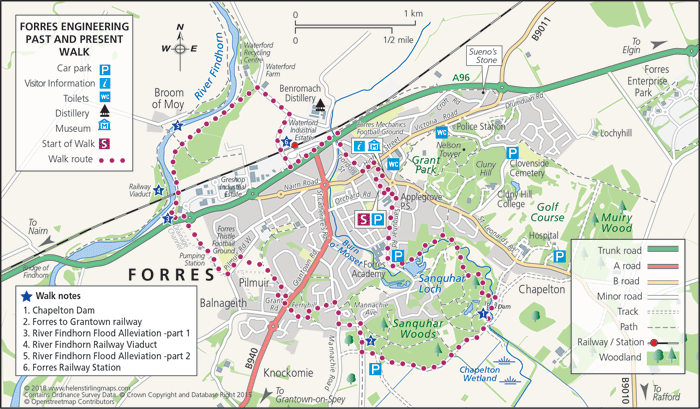
Parking is available in the Orchard Road Carpark, upon leaving the carpark cross the road and keeping the Primary School on your right walk along to Sanquhar Road. Once there walk along Sanquhar Road, keeping the Roysvale Park on your right.
Continue along until the road curves to the left, cross over and you will arrive at a small car parking area with a Forres Footpaths Trust stone pillar. Here turn left and take the footpath which runs alongside the pond. Before you make your way along the path though you may notice the water running down and through the overflow and if you re-cross the road you will see a fish ladder. Often referred to as Sanquhar Loch the pond was created in 1900 to provide water to the Benromach Distillery and a tannery which is no longer in existence. Follow the path alongside the pond and ignoring the steps up to your left you will arrive at a wooden bridge which allows you to cross the Burn o’ Mosset. Continue following the burn upstream and it will take you into the Sanquhar Woodlands where you will ascend a hill by a series of steps. Continue along the main path until you reach a T junction. Turn left and follow the undulating path back to the side of the burn. Continue for about 200m and turn a sharp left downhill descending to a second wooden bridge which allows you to cross the burn once more. The path curves right and joins another wider one as you emerge from the woods into the basin of the Chapleton Dam. Here you can see the testing and transfer station of the Romach Spring Water.
Head towards the Dam passing the outflow and go up to the rim. Here you can enjoy the view to Callifer Hill in the distance. Head upstream passing the bridge on your left and re-enter the woodlands passing the metal gate. Continue along this wide track until you come to the junction with a farm track coming from your left. Turn right following the purple arrow and walk along until you come to a bridge over a disused railway line. Turn right down the steps and at the bottom turn right. This time ignore the purple arrow and head into the cutting. Follow the track as it takes a ramp up to the right to meet the Mannachie Avenue. Turn left and walk along until you reach Mannachie Road where you turn right, cross the road and go downhill until you have passed the entrance to Grotvita Gardens. Here turn left along a tarmac path that runs between the rears of the houses situated on both sides. At the end of the houses turn left and after about 30m curve right on a path to pass between houses and cross over the mini-roundabout to go down Ferryhill to the main road (A940). Cross the road and turn right Very shortly, after a hedge, you will come to a small open green area on your left. Turn Left down this path which takes you the short distance to Grant Road which you follow round to the Left for about 100 metres then turn Right at sign West Grant Road onto the tarmac path and follow it as it winds along with an open area appearing on your left. As you approach trees ahead turn Left and go through the metal gate. Walk along the hard core path Come out onto the road and turn Left walking alongside the Forres Thistle football ground. At the end turn right through a wooden fence and continue along the track past the pumping station until you reach the roundabout on the A96. Cross the road, Keep the Mosset Burn on your right and proceed up Gordon Street. At the top turn left along Forres High Street and as the road narrows at the tollbooth turn, turn right down Tollbooth Street. At the bottom of the slope turn right and this will take you back to the start point.