The Speyside Way
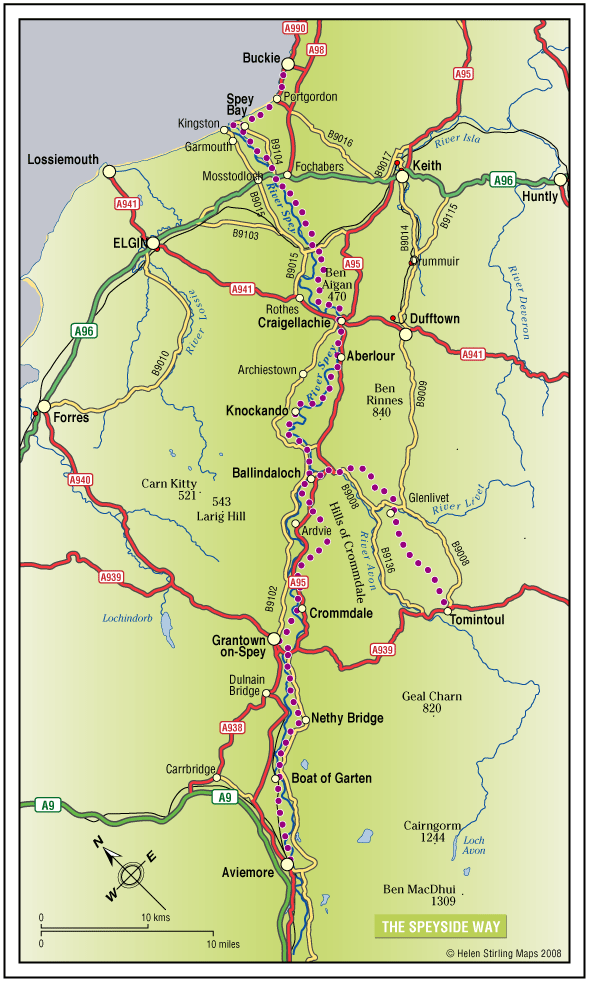
The Speyside Way is one of Scotland’s four official Long Distance Routes (LDRs). It runs between Aviemore, at the heart of Strathspey, 66 miles to Buckie, on the Moray Firth. The route passes through some of Scotland’s most beautiful landscapes; by rivers and mountains, over moorland and along forest paths. It includes a spur to Tomintoul, an additional 15 miles.
- Long Distance Walk
- Challenging
- 66 miles (105.6 km)
- Aberlour, Ballindalloch, Buckie, Craigellachie, Fochabers, Glenlivet, Portgordon, Spey Bay, Tomintoul
Accessibility: Suitable for a wide range of users
All of the route suitable for walkers. The route between Fochabers and Ballindalloch and between Nethy Bridge and Aviemore is suitable for cycling. The route is suitable for horseriding between Craigellachie and Ballindalloch.
Terrain: Varied surfaces
The route offers mainly easy walking on low ground (a mixture of seashore, river valley, old railway and moorland). It should be noted that the section between Ballindalloch and Grantown is more strenuous and the Tomintoul Spur is also steeper and passes through very exposed locations.
Gradient: Short steep sections
Most of the route is fairly level with some gentle slopes, although there are some steeper sections between Ballindalloch and Grantown. The Tomintoul Spur climbs to around 1,800ft above sea level at two locations.
- Fully signed
Report a route change
If you have followed this route and noticed any differences please report a route change by sending an email to:
Send us a GPX track
We would like to offer GPS tracks of all routes on this site.
If you are able to help please create a GPX track of this route (no detours) and send it to us for inclusion.
Generally the route is gentle rather than arduous, and footpaths are mostly well maintained; look out for the waymarkers in the design of a stylised thistle.
The Speyside Way Ranger Service is based at the Speyside Way Visitor Centre in Aberlour and is responsible for the day to day operation of the whole route.
PLEASE NOTE THAT THE SPEYSIDE WAY HAS BEEN DIVERTED DUE TO THE CLOSURE OF A DAMAGED BRIDGE AT DELFUR. THERE IS A SIGNED DIVERSION ROUTE IN PLACE.
MAY 2021 – Message from Moray Council Ranger service: Due to necessary bridge repair works at the Macdowall bridge the road ahead will be closed until 4th June. Please follow the Speyside Way Diversion through Ben Aigen forest. This diversion will be in place till 4th June. This diversion route will add an extra 2 kilometres onto the original route. We apologise for any inconvenience caused.
Users should make sure that they carry suitable clothing for all weather conditions.
All of the route suitable for walkers.
The route between Fochabers and Ballindalloch and between Nethy Bridge and Aviemore is suitable for cycling. The ‘offroad” sections between Ballindalloch and Tomintoul, and between Ballindalloch and Cromdale cannot sustain cycle traffic and you are asked to avoid them.
The route is suitable for horseriding between Craigellachie and Ballindalloch. Riders must be prepared to negotiate fords in two places, and a number of low, single rail stiles.
Contact
The Speyside Way Visitor Center
- Tel. 01340 881266
- The Old Station Building, Aberlour, Banffshire, AB38 9QP