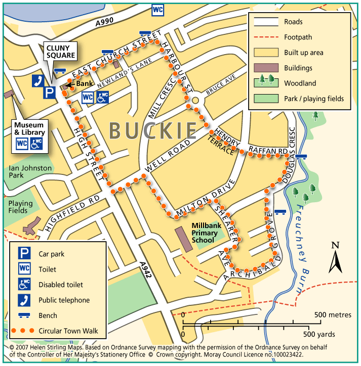
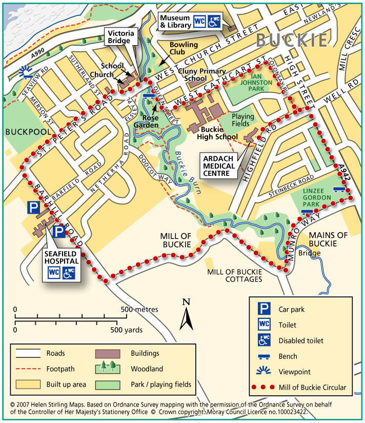
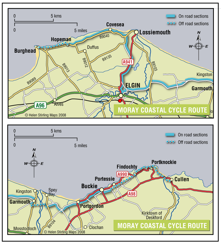
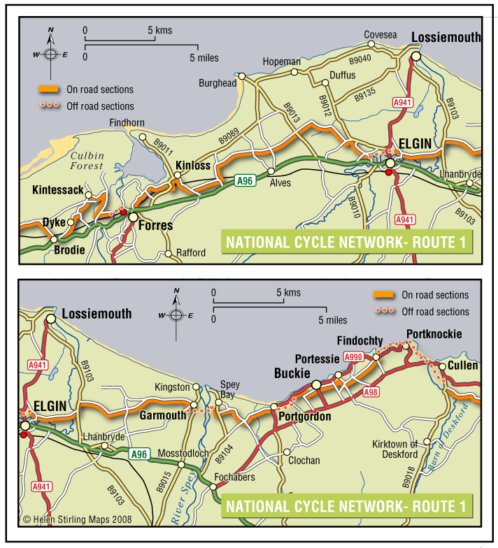
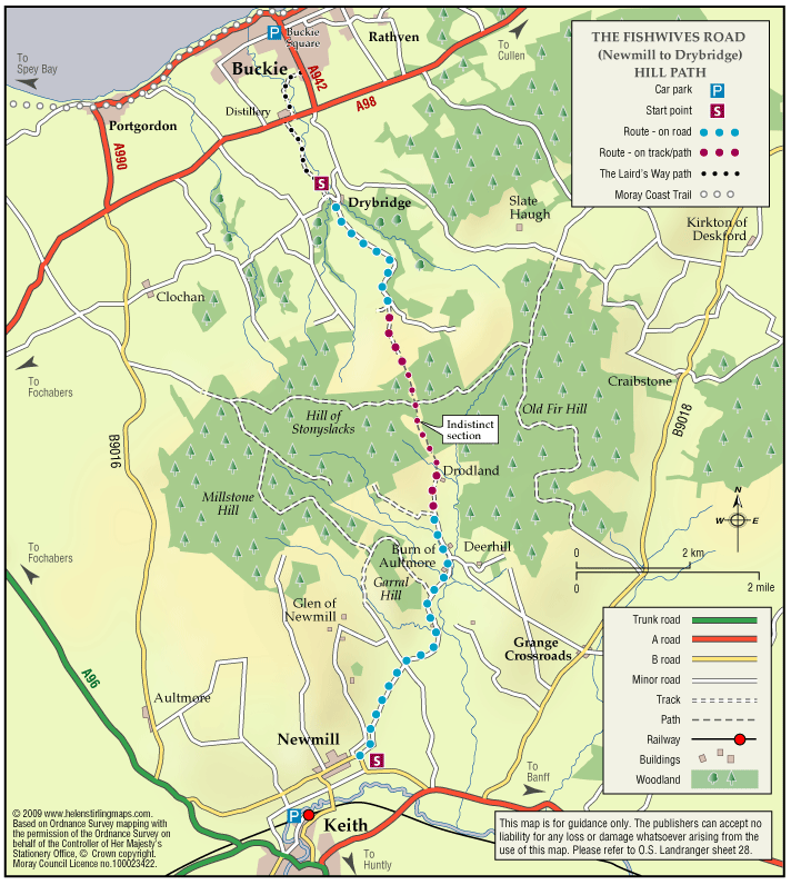
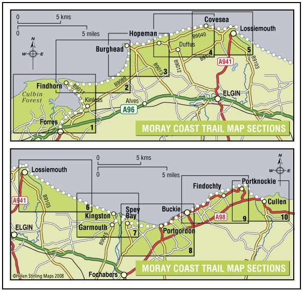
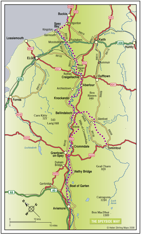
Buckie – Barhill Circular

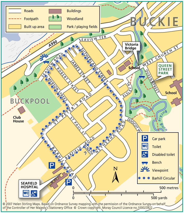
This is a circular walk along level roads and pavements and is suitable for wheelchairs and buggies. It includes great views from Seafield Hospital and Seaview Road, where there are benches to enjoy the panorama.

  • Accessible for all users
  • Paved footpaths & roads
  • Generally level
  • Partly signed

Buckie – Circular Town Walk

Although this circular walk is in town, there are excellent views of countryside and over the Moray Firth, making it an enjoyable walk any time of year. The route is along level paved surfaces and it is suitable for wheelchairs and buggies. There are benches and seats along the route.

  • Accessible for all users
  • Paved footpaths & roads
  • Gradient: Undulating

    Slight hill at Douglas Crescent.

  • Unsigned

Buckie – Gollachy Circular

This route explores the coast west of Buckie as far as the village of Portgordon, returning at a higher level with extensive views over the Moray Firth.

  • Accessible for all users
  • Terrain: Varied surfaces

    Tarred pavements and gravel paths. A short section of earth path at Gollachy Burn can be muddy.

  • Gradient: Short steep sections

    Short steep section climbing up to the golf course near the Gollachy Burn

  • Fully signed

Buckie – Laird’s Way to Drybridge

The peaceful village of Drybridge sits above Buckie surrrounded by woods and farmland. Follow the way from Buckie over the Buckie Burn and past the distillery. On the way to Drybridge you will be rewarded with fine views over farmland and beyond to the Firth.

  • Fully signed

Buckie – Mill of Buckie Circular

This circular walk is along country lanes, tracks and paved streets and is not suitable for wheelchairs or buggies. Parts of the route can be muddy in wet weather.

  • Unsuitable for wheelchairs and buggies
  • Terrain: Varied surfaces

    Tarmac pavements and farm track which can be muddy.

  • Generally level
  • Barriers: Some barriers

    Narrow bridge with steps at Mains of Buckie.

  • Partly signed

Buckie – Portessie Circular

This circular route starts in east Buckie and includes great coastal views over the Moray Firth. Because the route is very near to the shore for part of the way, it is very exposed to cold, strong winds from the sea. There are benches along the way. The surfaces are good and the only hill is on Station Road, which is fairly steep.

  • Accessible for all with care
  • Terrain: Paved footpaths & roads

    No pavement on Station Road.

  • Gradient: Short steep sections

    Steep slope at Station Road.

  • Barriers: Some barriers

    No drop kerbs on Rathburn Street.

  • Partly signed

Buckie – Queen Street Circular

Located within the town, this circular walk includes some beautiful open parkland. The route is along paved paths but care needs to be taken at the footbridge, which has steps and a handrail, making it unsuitable for wheelchairs or buggies.

  • Unsuitable for wheelchairs and buggies
  • Paved footpaths & roads
  • Generally level
  • Barriers: Some barriers

    Narrow bridge with steps and handrail in park.

  • Fully signed

Buckie – Round Rathven

This circular walk has some great coastal views over the Moray Firth and open countryside. The walk can be shortened by cutting along the path opposite Moray View Court.

  • Unsuitable for wheelchairs and buggies
  • Paved footpaths & roads
  • Short steep sections
  • Barriers: Some barriers

    Walking on road in places.

  • Partly signed

Buckie – Strathlene all abilities path

Located near Buckie, this is a short section of coastal all abilities path, which runs parallel to the rocky foreshore near the old Strathlene lido. There are views to the nearby Craigen Roan rock where seals can be regularly seen and heard. This path forms part of the Moray Coast Trail – Buckie.

  • Accessible for all users
  • Gravel path
  • Generally level
  • Fully signed

Moray Coastal Cycle Route

This is a signed cycle route from Burghead to Cullen, linking the coastal communities. Explore the dramatic landscapes from rugged cliffs to sweeping shores, sheltered coves to fishertown harbours. Visitors are drawn by the resident bottlenose dolphins and the myriad of birdlife on the cliffs.

  • Accessibility: Suitable for a wide range of users

    Suitable for all types of bikes. Some sections are suitable for walking and horse riding.

  • Terrain: Paved footpaths & roads

    Good surfacing through out, combining a mixture of gravel paths, tarmac paths, and public road sections.

  • Generally level
  • Barriers: Some barriers

    Some road crossings.

  • Fully signed

The Fishwives Route

Follow the footsteps of the Fishwives. The Fishwives Path starts at the Buckie & District Fishing Heritage Centre where you will discover the unique fishing history of this lovely part of the Moray Firth.

  • Accessibility: Suitable for a wide range of users

    Suitable for more able and energetic walkers. The off road sections would be of interest to horse riders and mountain bikers.

  • Terrain: Varied surfaces

    Nearly two thirds of the route is along tarmac roads and paths which are easy to negotiate. The rest is on farm/forestry tracks and grassy paths; the surface in places is rough and uneven and can be muddy in wet weather.

  • Gradient: Gentle gradients

    The route climbs from the sea at Buckie to around 270 metres (900ft) above sea level. From both the Keith and Buckie ends the path rises gradually to the highest point at Addie Hill.

  • Barriers: Some barriers

    Gates

  • Fully signed

The Moray Coast Trail

The coastline and settlements of Moray are linked by a waymarked coastal trail of approximately 50 miles from Findhorn to Cullen and all the places between. The route can be extended from Findhorn to Forres along a section of cycle route.

  • Accessibility: Suitable for a wide range of users

    Many sections of the route can be used for cycling and horseriding in addition to walking. In wilder locations the path can be steep and rough in places, which would restrict access. Generally the route is most accessible in the vicinity of the coastal settlements. Less able users should concentrate on using these sections.

  • Terrain: Varied surfaces

    There are varied surfaces including tar, gravel and earth paths, with some beach and rock sections. In places the trail follows pavements through the towns and villages, whilst in other areas the route uses rough tracks along the coastal clifftops and forests.

  • Gradient: Generally level

    Generally level with some short steep climbs in places.

  • Barriers: Some barriers

    There are steps and gates in some sections, particularly along the rugged coastline at the Hopeman Ridge and between Buckie and Cullen.The route crosses Lossiemouth and Cullen beaches at low tide, but at high tide you will have to follow an alternative (unsigned) foreshore route.The section between Lossie and Kingston has the military firing range and when in use red flags are hoisted at each corner which prevent users from progressing further, for information on which days the range is being used telephone Fort George on 0131 310 8692.

  • Fully signed

The Speyside Way

The Speyside Way is one of Scotland’s four official Long Distance Routes (LDRs). It runs between Aviemore, at the heart of Strathspey, 66 miles to Buckie, on the Moray Firth. The route passes through some of Scotland’s most beautiful landscapes; by rivers and mountains, over moorland and along forest paths. It includes a spur to Tomintoul, an additional 15 miles. 

  • Accessibility: Suitable for a wide range of users

    All of the route suitable for walkers. The route between Fochabers and Ballindalloch and between Nethy Bridge and Aviemore is suitable for cycling. The route is suitable for horseriding between Craigellachie and Ballindalloch.

  • Terrain: Varied surfaces

    The route offers mainly easy walking on low ground (a mixture of seashore, river valley, old railway and moorland). It should be noted that the section between Ballindalloch and Grantown is more strenuous and the Tomintoul Spur is also steeper and passes through very exposed locations.

  • Gradient: Short steep sections

    Most of the route is fairly level with some gentle slopes, although there are some steeper sections between Ballindalloch and Grantown. The Tomintoul Spur climbs to around 1,800ft above sea level at two locations.

  • Many barriers
  • Fully signed