Forres – Califer Hill & Rafford
A circular walk along minor roads and footpaths with stunning views from Califer Viewpoint, returning via lower Rafford and the Dava Way with a shorter route option from Rafford Church available.
- Suitable for a wide range of users
Terrain: Varied surfaces
Minor Roads, Grassy Lanes, Farm Tracks, Footpaths, Woodland Tracks, some potentially muddy and slippy parts following wet weather and some narrower sections.
Gradient: Generally level
Most of this route is relatively level with the steepest section being the ascent and descent to and from Califer Hill Viewpoint. The viewpoint ascends to 184.5m.
- Unsigned
Report a route change
If you have followed this route and noticed any differences please report a route change by sending an email to:
Send us a GPX track
We would like to offer GPS tracks of all routes on this site.
If you are able to help please create a GPX track of this route (no detours) and send it to us for inclusion.
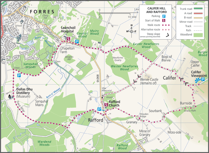
We recommend starting from the Council Woods car park, 200yards along the road towards Califer Viewpoint from the Leanchoil Hospital – shown on the route map. Walking the 2.6mile road section towards Califer Viewpoint first. Take care on the narrow roads! Alternatively you can use the Dial M for Moray bus service to take you to the Califer Hill Viewpoint to avoid walking that section of the road.
Once at the Califer Hill Viewpoint you will be rewarded with a panoramic view of the Moray Firth and there is also an informative viewing platform providing distances and directions of what can be seen.
The next section of the walk to the Rafford Church has sections where it can be muddy and slippery when wet but provides good views of the Blervie Castle to your right.
The Rafford Church was built in 1826 with later additions including a magnificent stained glass window.
The third section of the walk takes you along a part of the Dava Way – see the link below – crossing the Mosset Burn and passing by the historic Dallas Dhu, a good place to stop and rest.
The final section will take you through woodland which is maintained by the Forres Community Woodlands Trust then along the top of a ridge with a dam below which is part of the £20 million scheme to prevent flooding in the Forres area. You will then re-cross the Mosset Burn over a wooden footbridge, walk through the no longer working, Chapleton Farm and out onto the road back to the start point at Leanchoil Hospital.
There is also a Shorter Circular Walk from Rafford Church – 4 miles in length.
From Rafford Church (NJ 061543) return to the B 9010 and turn Right (towards Forres) taking care as you walk along the road for 50 yards. Turn Right at the war memorial and continue along the minor road past Blervie Castle until you come to the first cross roads (NJ073575). Here, you turn Right and join the main route instructions above to walk up the hill to the viewpoint. Follow the instructions until you return to Rafford Church.