The Fishwives Route
Follow the footsteps of the Fishwives. The Fishwives Path starts at the Buckie & District Fishing Heritage Centre where you will discover the unique fishing history of this lovely part of the Moray Firth.
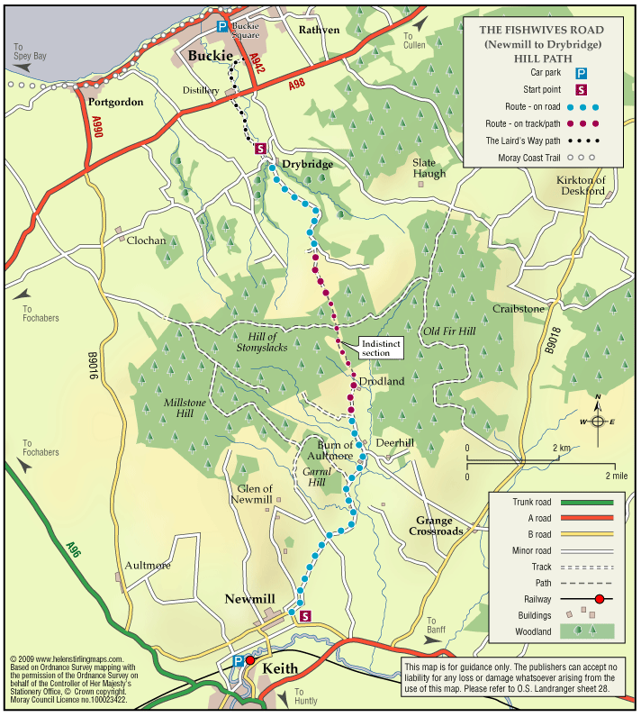
Accessibility: Suitable for a wide range of users
Suitable for more able and energetic walkers. The off road sections would be of interest to horse riders and mountain bikers.
Terrain: Varied surfaces
Nearly two thirds of the route is along tarmac roads and paths which are easy to negotiate. The rest is on farm/forestry tracks and grassy paths; the surface in places is rough and uneven and can be muddy in wet weather.
Gradient: Gentle gradients
The route climbs from the sea at Buckie to around 270 metres (900ft) above sea level. From both the Keith and Buckie ends the path rises gradually to the highest point at Addie Hill.
- Fully signed
Report a route change
If you have followed this route and noticed any differences please report a route change by sending an email to:
Send us a GPX track
We would like to offer GPS tracks of all routes on this site.
If you are able to help please create a GPX track of this route (no detours) and send it to us for inclusion.
****As part of the annual Speyside Stages Car Rally, this year they will be holding a stage in Aultmore forest on Saturday 22nd April, so this path will be closed on Friday 21 April and Saturday from 08:30 – 12:30*****
Humans from this coast have always fished the sea; however, the introduction of herring fishing in the 19th Century brought major changes. Harbours were developed, boats became bigger, and in addition to exporting catches by sea, the railways distributed large quantities of fish to the home market. Fishing had become an industry.
Distribution to the people in the immediate hinterland was done on foot by fishwives with wicker baskets on their backs, each carrying about 40lbs of fish. Their trade was mostly by barter, exchanging fish for farm produce. All along the coast scores of fishwives would follow individual routes and have their own customers.
“The Fishwives Path to Keith” celebrates their walk of thirteen miles approximately from Buckie to Keith, visiting farms and crofts on the way. The first six miles of the fishwife’s route took her south over the skyline, to look out over the valley of the River Isla, before continuing for another six miles through Newmill to Keith.
The Route
Fine views of the Banffshire countryside and Moray Firth, with the added interest of historical connection of the Fishwives. The settlements along the route offer a glimpse into the past of this part of Banffshire.
*Please note that there is a new route through a forest that comes out just past Drodland Farm which is not shown on the map on this page. Please refer to the signposts on the route.
Buckie is the largest town in Banffshire. Back in the late 19th Century was one of the most important herring fishing ports in Scotland and up until recently was an important location for the repair and maintenance of RNLI lifeboats.
Newmill is a great example of a ‘planned’ village.
Keith is one of Scotland’s first planned towns and has 3 distilleries, one is the oldest legally operating distillery in Highlands-the Strathisla Distillery. One time textiles played a major influence on the wealth of Keith, but sadly the only thing left is the Keith Kilt and textile centre, the only school of its kind in the world, where students are trained in the art of kilt-making. Keith has two renowned festivals, the Keith Country Music festival in early June and Keith Country Show in early August.
Safety
Considerable sections of the route are along quiet, narrow country roads where traffic flows are low. Nevertheless please take care as there are no pavements. Please also take care when crossing the busy A98 Inchgower Distillery near Buckie. Users need to decide for themselves whether they feel comfortable following the road section along the B9116 between Newmill and Keith where they will be exposed to fast-moving traffic. Stout footwear and waterproof clothing are essential as parts of the route are exposed and can be rough and wet.
As a working forest, it is not unusual to find the Forestry Commission working through the summer. The public may come across a diversion on the route; we do ask that you follow any signs as there are for your own safety.