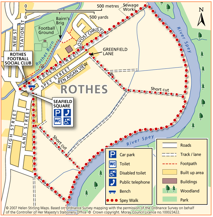
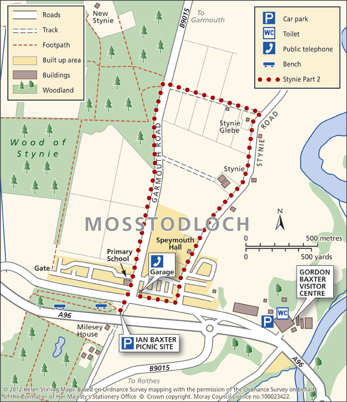
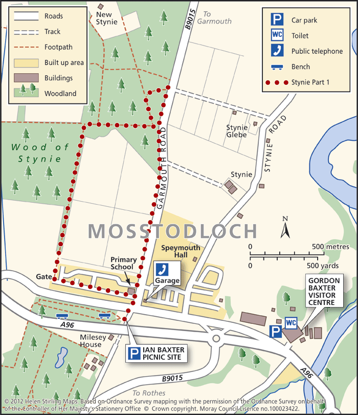
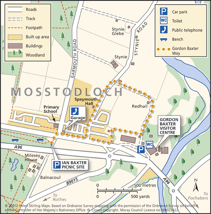
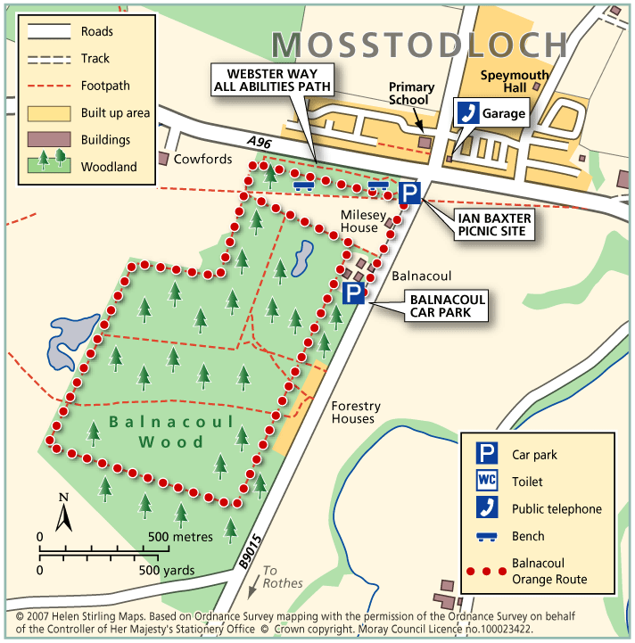
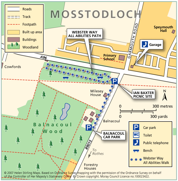
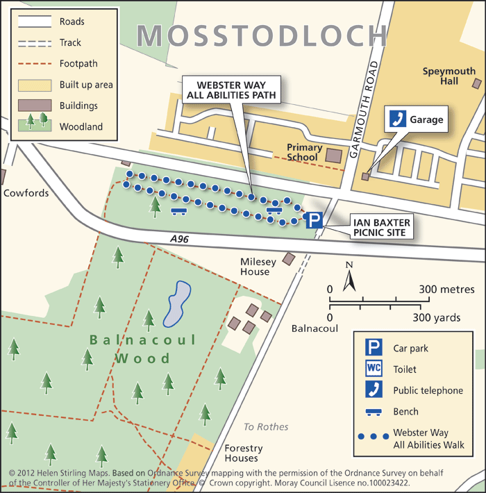
Rothes – Burn Walk

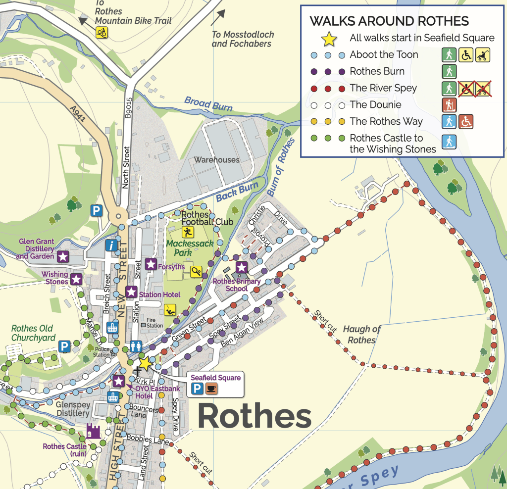
This flat, circular walk follows the Rothes Burn as it passes through the Playing Fields and also includes some great views over the open countryside to Ben Aigen. The surfaces are all good and are suitable for wheelchairs and buggies, although care is needed over the footbridges.

  • Accessible for all users
  • Paved footpaths & roads
  • Generally level
  • Barriers: No barriers

    Take care crossing the footbridges.

Rothes – The Dounie

This walk follows the Rothes Burn upstream to the Giant’s Table and the Fairy Rock – volcanic outcrops worn and shaped by thousands of years of erosion – and returns by the track skirting the golf course.

  • Suitable for a wide range of users
  • Varied surfaces
  • Gradient: Mixed gradient

    Varying gradients, climbing to 250m.

  • Barriers: Some barriers

    Some steps

  • Fully signed

Rothes – Spey Walk

This flat, circular walk follows the River Spey on it’s way from Craigellachie to Boat o’ Brig. The path is good but is not suitable for wheelchairs or buggies. The scenery along this walk is very beautiful at any time of year, although it can be a little exposed in places and the paths can be muddy in wet weather.

  • Unsuitable for wheelchairs and buggies
  • Terrain: Varied surfaces

    Mainly grass and earth path, with some sections of farm track and tarmac. Paths can be muddy when wet.

  • Generally level

Ben Aigan and Knockmore

This ride takes you to the transmitter on Knockmore, the summit of Ben Aigan and stunning views of Speyside. The route described is not way-marked by the Forestry Commission as a horse-riding trail.

  • Terrain: Varied surfaces

    Mostly forest roads, some open moorland and one steep grassy track. The climb to the summit is very stony.

  • Mixed gradient

Ben Aigan

Ben Aigan lies to the east of Rothes, the north east of Craigellachie and to the east of the River Spey which flows along the foot of its western and northern slopes. Rising to a height of 471m (1546 feet) and extensively forested apart from the summit cone, the top of Ben Aigan provides magnificent views over Speyside, south to Ben Rinnes, and away to the north over the Moray Firth to the hills of Sutherland

  • Unsuitable for wheelchairs and buggies
  • Defined hill path
  • Slopes throughout
  • Partly signed

Mosstodloch – Stynie east

This is a good level walk along tracks and roads and has great countryside views. It shouldn’t be attempted in really cold or windy weather as there are places where the track is very exposed.

  • Unsuitable for wheelchairs and buggies
  • Terrain: Varied surfaces

    Country roads, farm tracks and compacted earth paths. Care to be taken on the road sections as no pavements.

  • Generally level

Mosstodloch – Stynie west

This is a circular walk from Mosstodloch, through mature forest along tarmac road and forest tracks. The tracks can be muddy when wet. Go quietly and you may see red squirrels.

  • Unsuitable for wheelchairs and buggies
  • Terrain: Varied surfaces

    A mixture of pavements, farm tracks and compacted earth paths. Can be muddy in wet weather and is quite exposed.

Mosstodloch – Gordon Baxter Way

This is a circular, level walk with good views of the countryside. The tracks can be muddy if wet and this walk shouldn’t be undertaken on a windy day as it is exposed in places.

  • Unsuitable for wheelchairs and buggies
  • Terrain: Varied surfaces

    Farm tracks and tarmac. Can be muddy.

  • Generally level

Mosstodloch – Balnacoul Orange Route

This is a signposted circular route which starts on the All Abilities path and extends into the wood. The tracks are all level and suitable for buggies, although wheelchairs may struggle on the compacted earth surface.

  • Suitable for buggies but not wheelchairs
  • Terrain: Varied surfaces

    Compacted earth paths with gravel in sections. Can be muddy.

  • Generally level
  • No barriers
  • Fully signed

Mosstodloch – Webster Way All Abilities

This is a circular walk along a purpose built trail for wheelchairs and buggies, through forest plantation. The tracks are good all year round and there are picnic tables at the start. This is a good opportunity for red squirrel watching as well as the woodland birdlife.

  • Accessible for all users
  • Gravel path
  • Generally level
  • No barriers
  • Fully signed

Archiestown – Cairn Cattoch

Cairn Cattoch Walk is one of several waymarked walks within the forest to the north of Archiestown.

  • Accessibility: Suitable for a wide range of users

    The route is suitable for a wide range of users, although cyclists may require to dismount on the short section to the viewpoint

  • Terrain: Forest tracks

    Mainly on forest track. There is a short section of rough earth path through heather to reach the summit viewpoint. Stout footwear is advised

  • Gradient: Mixed gradient

    Long gentle climb along most of route, with a steeper section leading to the viewpoint. A total climb of 130 metres (390ft) with the summit sitting at 369 metres (1120ft) above sea level

  • No barriers
  • Fully signed

Mosstodloch – Webster Way

This is a circular walk along a purpose built trail for wheelchairs and buggies, through forest plantation. The tracks are good all year round and there are picnic tables at the start. This is a good opportunity for red squirrel watching as well as the woodland birdlife. This is a popular dog walking path.

  • Accessible for all users
  • Paved footpaths & roads
  • Generally level
  • No barriers
  • Fully signed

Elgin – New Elgin Circular

This is a circular walk, which starts in Edgar Road and loops round south Elgin. It is all on good pavements and is suitable for wheelchairs and buggies.

  • Accessible for all users
  • Paved footpaths & roads
  • Gradient: Generally level

    Mainly level with some steady inclines and declines.