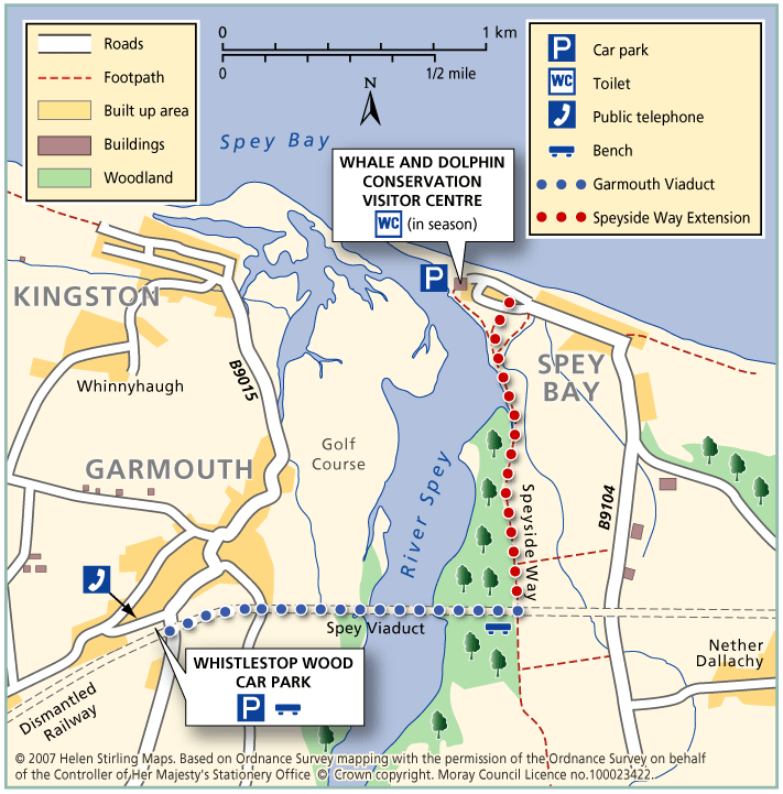
Garmouth – The Lein and Bin Hill

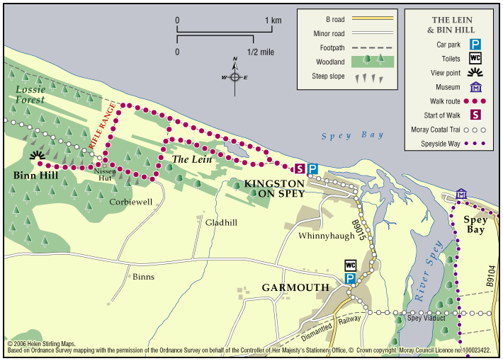
The Lein is the name given to this area of massive shingle beaches the largest in Scotland – that run west of the mouth of the River Spey. They are part of a Scottish Wildlife Trust reserve and offer good dolphin-spotting. Ospreys also fish the river mouth in summer.

  • Unsuitable for wheelchairs and buggies
  • Terrain: Coastal tracks

    Generally good level shingle and earth paths though some sections may be undulating and slippery in the wet. The section to the Bin Hill is steep.

  • Gradient: Short steep sections

    If you choose to climb to the top of the Bin Hill the path is steep.

  • Barriers: Some barriers

    There are height restrictive barriers in place at the car park and the start of the path. If red flags are raised at the rifle range path users must not proceed into this area.

  • Fully signed

Garmouth – Viaduct

This walk follows the old railway track from Garmouth over the River Spey viaduct, with great views over the golf course to the sea at Kingston. It is part of the National Cycle Network and also the Speyside Way. The track is good and suitable for wheelchairs and buggies.

  • Accessibility: Accessible for all users

    The extended route Level 3 is unsuitable for wheelchairs and buggies.

  • Terrain: Paved footpaths & roads

    Tarmac and all abilities surface over viaduct. The extended level 3 route is compacted earth path and can be muddy in wet weather.

  • Generally level
  • No barriers

Lhanbryde – Loch Na Bo Walks

Located just a few miles east of Elgin, the woodland and countryside around the village of Lhanbryde provide a great opportunity for outdoor access.

  • Unsuitable for wheelchairs and buggies
  • Terrain: Varied surfaces

    Pavements, farm tracks and informal woodland paths (gravel and earth). Some paths can be muddy in places, so stout footwear is recommended.

  • Generally level
  • Barriers: Some barriers

    Crossing of the busy A96 road - great care required.

  • Partly signed

Moray Coastal Cycle Route

This is a signed cycle route from Burghead to Cullen, linking the coastal communities. Explore the dramatic landscapes from rugged cliffs to sweeping shores, sheltered coves to fishertown harbours. Visitors are drawn by the resident bottlenose dolphins and the myriad of birdlife on the cliffs.

  • Accessibility: Suitable for a wide range of users

    Suitable for all types of bikes. Some sections are suitable for walking and horse riding.

  • Terrain: Paved footpaths & roads

    Good surfacing through out, combining a mixture of gravel paths, tarmac paths, and public road sections.

  • Generally level
  • Barriers: Some barriers

    Some road crossings.

  • Fully signed

The Moray Coast Trail

The coastline and settlements of Moray are linked by a waymarked coastal trail of approximately 50 miles from Findhorn to Cullen and all the places between. The route can be extended from Findhorn to Forres along a section of cycle route.

  • Accessibility: Suitable for a wide range of users

    Many sections of the route can be used for cycling and horseriding in addition to walking. In wilder locations the path can be steep and rough in places, which would restrict access. Generally the route is most accessible in the vicinity of the coastal settlements. Less able users should concentrate on using these sections.

  • Terrain: Varied surfaces

    There are varied surfaces including tar, gravel and earth paths, with some beach and rock sections. In places the trail follows pavements through the towns and villages, whilst in other areas the route uses rough tracks along the coastal clifftops and forests.

  • Gradient: Generally level

    Generally level with some short steep climbs in places.

  • Barriers: Some barriers

    There are steps and gates in some sections, particularly along the rugged coastline at the Hopeman Ridge and between Buckie and Cullen.The route crosses Lossiemouth and Cullen beaches at low tide, but at high tide you will have to follow an alternative (unsigned) foreshore route.The section between Lossie and Kingston has the military firing range and when in use red flags are hoisted at each corner which prevent users from progressing further, for information on which days the range is being used telephone Fort George on 0131 310 8692.

  • Fully signed