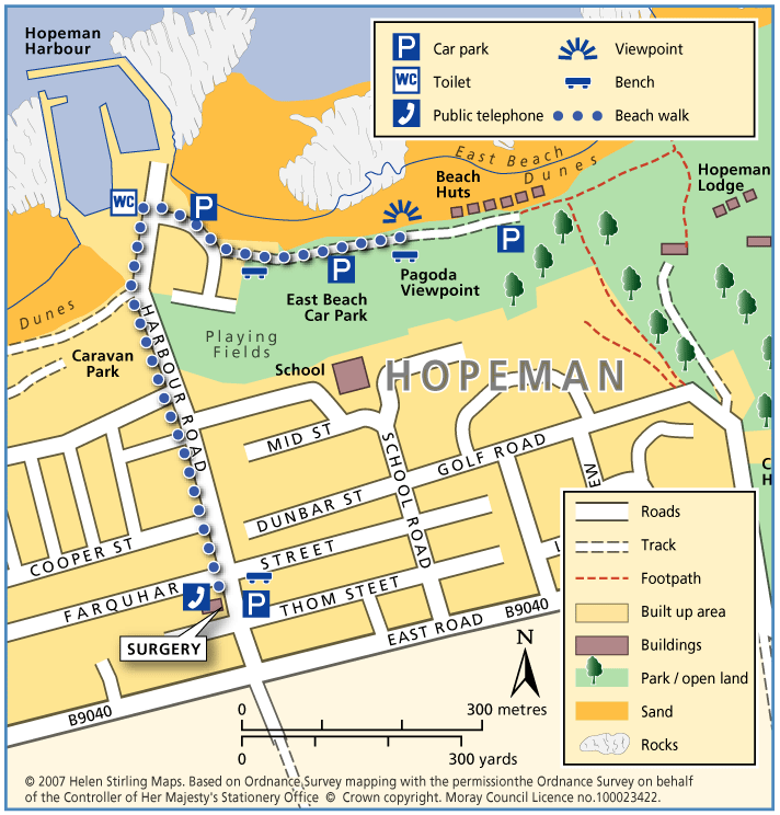
Hopeman – Beach and Lodge Walk

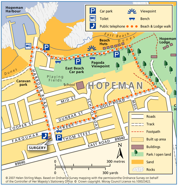
This is an extension of the Level 1 Beach Walk, following the coast path past the beach huts and turning inland up Lodge Lane.

  • Unsuitable for wheelchairs and buggies
  • Terrain: Varied surfaces

    Mainly tarmac pavements and paths, but gravel section at Lodge Lane. Care to be taken on Lodge Lane, which can be muddy in wet weather.

  • Gradient: Short steep sections

    Steady incline up lodge lane. Relatively level elsewhere.

Hopeman – Beach Walk

This walk is from the Surgery on Harbour Street to the Pagoda viewpoint on East Beach and back again. The paths are good and suitable for wheelchairs and buggies. There are toilets at the bottom of Harbour Street and plenty of benches along the way. This walk can be a little exposed if the wind is strong.

  • Accessible for all users
  • Paved footpaths & roads
  • Generally level
  • No barriers

Hopeman – Railway Path

This walk takes you from Hopeman Surgery on a circular route along part of the old railway line to Cummingston. It is quite sheltered along the old track and has lovely views over the Moray Firth with potential to spot dolphins. The section from Cummingston back towards Hopeman is along a pavement next to a relatively busy road so care will be required.

  • Unsuitable for wheelchairs and buggies
  • Terrain: Varied surfaces

    Gravel paths and tarmac pavements.

  • Gradient: Generally level

    Relatively level, with short downwards slope to the old railway line in Hopeman and short steep incline to the bridge near Cummingston.

  • Barriers: Some barriers

    Steps down to railway path at the Hopeman end.

  • Partly signed

Moray Coastal Cycle Route

This is a signed cycle route from Burghead to Cullen, linking the coastal communities. Explore the dramatic landscapes from rugged cliffs to sweeping shores, sheltered coves to fishertown harbours. Visitors are drawn by the resident bottlenose dolphins and the myriad of birdlife on the cliffs.

  • Accessibility: Suitable for a wide range of users

    Suitable for all types of bikes. Some sections are suitable for walking and horse riding.

  • Terrain: Paved footpaths & roads

    Good surfacing through out, combining a mixture of gravel paths, tarmac paths, and public road sections.

  • Generally level
  • Barriers: Some barriers

    Some road crossings.

  • Fully signed

The Moray Coast Trail

The coastline and settlements of Moray are linked by a waymarked coastal trail of approximately 50 miles from Findhorn to Cullen and all the places between. The route can be extended from Findhorn to Forres along a section of cycle route.

  • Accessibility: Suitable for a wide range of users

    Many sections of the route can be used for cycling and horseriding in addition to walking. In wilder locations the path can be steep and rough in places, which would restrict access. Generally the route is most accessible in the vicinity of the coastal settlements. Less able users should concentrate on using these sections.

  • Terrain: Varied surfaces

    There are varied surfaces including tar, gravel and earth paths, with some beach and rock sections. In places the trail follows pavements through the towns and villages, whilst in other areas the route uses rough tracks along the coastal clifftops and forests.

  • Gradient: Generally level

    Generally level with some short steep climbs in places.

  • Barriers: Some barriers

    There are steps and gates in some sections, particularly along the rugged coastline at the Hopeman Ridge and between Buckie and Cullen.The route crosses Lossiemouth and Cullen beaches at low tide, but at high tide you will have to follow an alternative (unsigned) foreshore route.The section between Lossie and Kingston has the military firing range and when in use red flags are hoisted at each corner which prevent users from progressing further, for information on which days the range is being used telephone Fort George on 0131 310 8692.

  • Fully signed