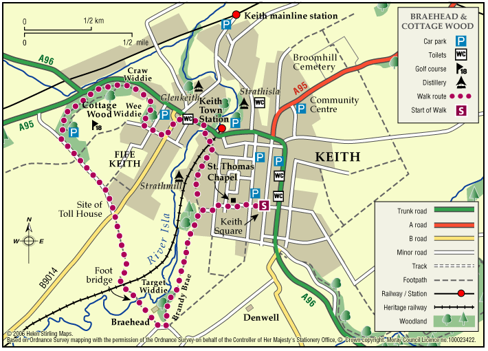
Keith – Braehead and Cottage Wood

This nature walk has an abundance of flowers, shrubs, trees and wildlife along the river and hedges set against a background of heather and tree clad hills.

  • Suitable for a wide range of users
  • Terrain: Varied surfaces

    A combination of tarred minor roads, aggregate paths and grassy tracks.

  • Undulating
  • Barriers: Some barriers

    Steps in two places (The Cottage Wood and the Auld Brig)

  • Fully signed

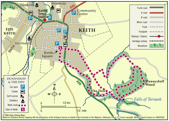
Keith – Dunnyduff and The Den

This walk is part of a network of waymarked and signed paths linking all the delights the Keith area has to offer. The route can be enjoyed in both directions, starting and finishing at the map information board in Keith Square (Reidhaven Square). 

  • Accessibility: Unsuitable for wheelchairs and buggies

    Suitable for a wide range of users in the flat sections near Keith but in the countryside the route is appropriate for more able, energetic persons. Horse riding is not recommended at Tarnash due to the steep nature of the path linking to Dunnyduff.

  • Terrain: Varied surfaces

    A combination of roadside pavements, minor roads, green tracks and some rougher paths with several steep inclines.

  • Short steep sections
  • Barriers: Some barriers

    Some steps exist in Dunnyduff Wood.

  • Fully signed

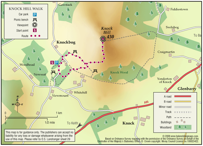
Knock Hill & Little Knockbog

The starting point suggested is very overgrown and there is now “no right of way signs” placed. This is not a core path. There is potentially another route up via Swiebog. The car park is now closed for public use. If you have more information on this route or you would like to help maintain …

  • Unsuitable for wheelchairs and buggies
  • Slopes throughout
  • Barriers: Some barriers

    Very overgrown

  • Partly signed

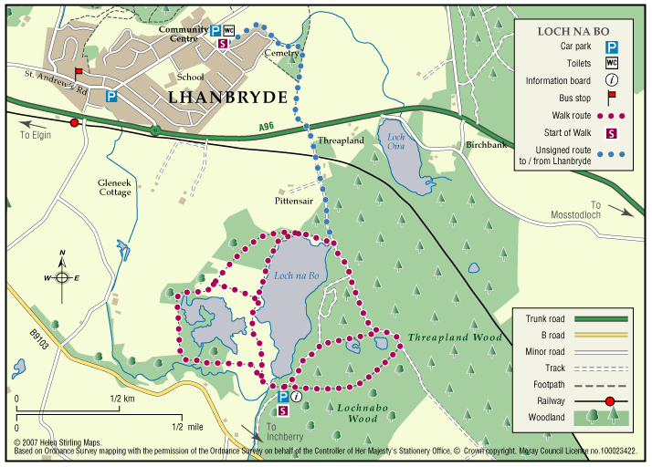
Lhanbryde – Loch Na Bo Walks

Located just a few miles east of Elgin, the woodland and countryside around the village of Lhanbryde provide a great opportunity for outdoor access.

  • Unsuitable for wheelchairs and buggies
  • Terrain: Varied surfaces

    Pavements, farm tracks and informal woodland paths (gravel and earth). Some paths can be muddy in places, so stout footwear is recommended.

  • Generally level
  • Barriers: Some barriers

    Crossing of the busy A96 road - great care required.

  • Partly signed

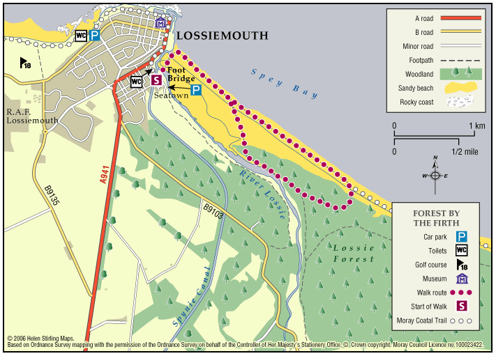
Lossiemouth – Forest by the Firth Trail 

The town commands the prominent headland at the mouth of the River Lossie. It has dramatic and beautiful beaches, wonderful countryside and plenty to see and do. Part of the route follows the long-distance Moray Coast Trail. 

  • Accessibility: Unsuitable for wheelchairs and buggies

    Due to the loose sand and shingle, the route is unsuitable for wheelchairs, buggies or road bikes.

  • Terrain: Varied surfaces

    The route follows the sandy beach, with areas of loose shingle, and forest tracks. The trail can also be damp through the salt marsh area. Sturdy footwear is advised.

  • Gradient: Generally level

    Relatively level, except short steep shingle ridge of around 2 metres in height.

  • Barriers: Some barriers

    During high Spring Tides the route may be impassable along the beach. The trail requires a short scramble over a steep section of loose shingle (approx 2 metre height) to the dunes. Access to the beach is over a long narrow timber bridge.

  • Partly signed

Rothes – The Dounie

This walk follows the Rothes Burn upstream to the Giant’s Table and the Fairy Rock – volcanic outcrops worn and shaped by thousands of years of erosion – and returns by the track skirting the golf course.

  • Suitable for a wide range of users
  • Varied surfaces
  • Gradient: Mixed gradient

    Varying gradients, climbing to 250m.

  • Barriers: Some barriers

    Some steps

  • Fully signed

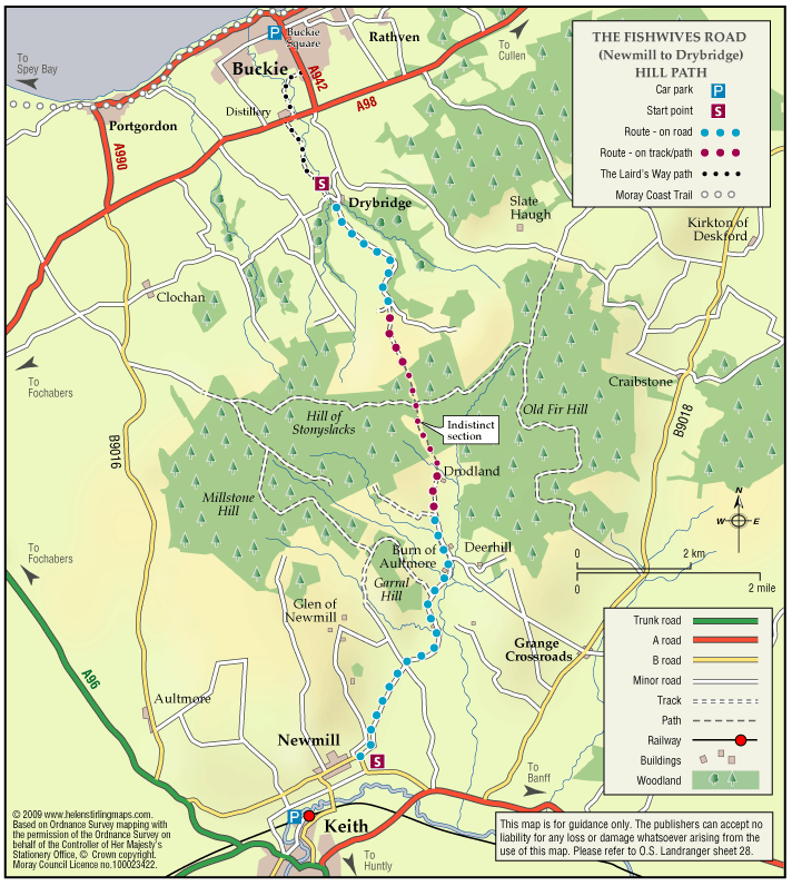
The Fishwives Route

Follow the footsteps of the Fishwives. The Fishwives Path starts at the Buckie & District Fishing Heritage Centre where you will discover the unique fishing history of this lovely part of the Moray Firth.

  • Accessibility: Suitable for a wide range of users

    Suitable for more able and energetic walkers. The off road sections would be of interest to horse riders and mountain bikers.

  • Terrain: Varied surfaces

    Nearly two thirds of the route is along tarmac roads and paths which are easy to negotiate. The rest is on farm/forestry tracks and grassy paths; the surface in places is rough and uneven and can be muddy in wet weather.

  • Gradient: Gentle gradients

    The route climbs from the sea at Buckie to around 270 metres (900ft) above sea level. From both the Keith and Buckie ends the path rises gradually to the highest point at Addie Hill.

  • Barriers: Some barriers

    Gates

  • Fully signed

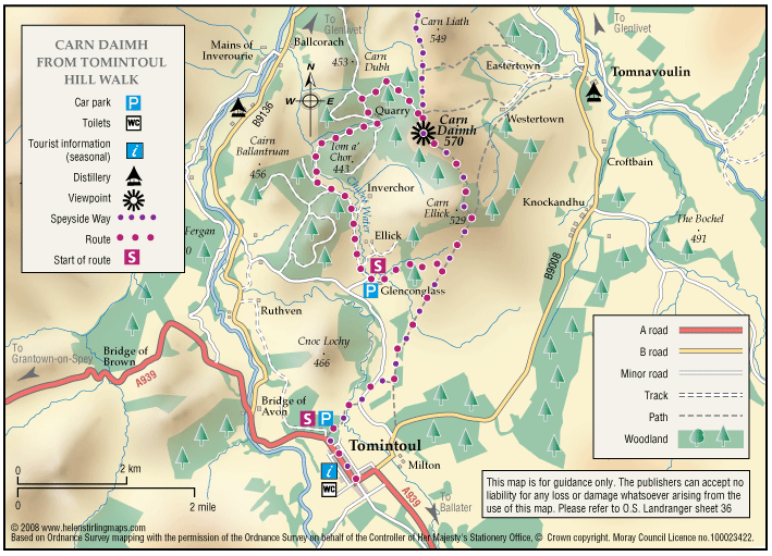
Tomintoul – Carn Daimh

Cairn Daimh (Hill of the Stags) at 1866ft (570m) is most often ascended in the course of following the Tomintoul Spur of the Speyside Way, between Glenlivet and Tomintoul.

  • Partly signed