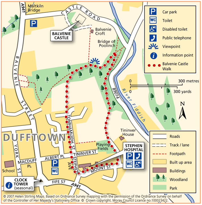
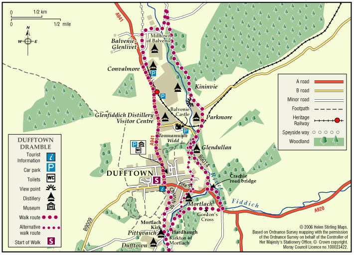
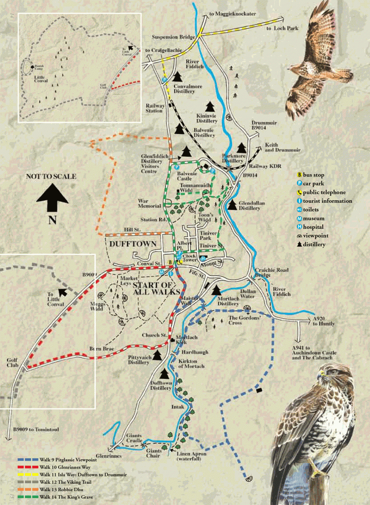
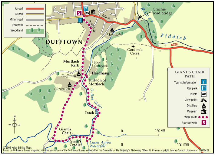
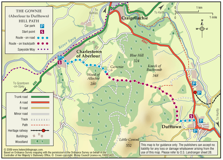
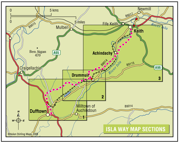
Ben Rinnes

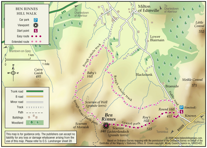
Ben Rinnes is the highest freestanding mountain in Moray at 2733ft (841 metres), and is classified as a ‘Corbett’ – a summit lying between 2500ft and 2999ft. 

  • Unsuitable for wheelchairs and buggies
  • Defined hill path
  • Slopes throughout
  • Unsigned

Dufftown – Balvenie Castle

This circular walk has some steep inclines and is not suitable for wheelchairs or buggies because of the terrain. It includes some woodland and has good views of the ruined castle.

  • Unsuitable for wheelchairs and buggies
  • Terrain: Varied surfaces

    Tarmac pavements, compacted earth and gravel tracks. Note that the earth track in the wood is quite narrow and can be muddy/ slippy in wet weather. Watch out for tree roots.

  • Gradient: Short steep sections

    Some steep inclines / declines, with the steepest on a ramped path section within the woodland.

  • Barriers: Some barriers

    Long flight of steps in wood.

  • Partly signed

Dufftown – Dufftown Dramble

‘Rome was built on seven hills, Dufftown was built on seven stills’ – so goes the old rhyme. This walk, starting from the Dufftown clock-tower, links all the Dufftown distilleries in one walk.

  • Accessibility: Suitable for a wide range of users

    Able-bodied walkers, some sections can be cycled. The nature of the terrain and the presence of physical barriers would make the route difficult to negotiate on horseback.

  • Terrain: Varied surfaces

    A mixture of tarmac, gravel and grass paths with some sections on public roads - look out for traffic. Short gradients and sections of uneven path.

  • Gradient: Undulating

    Generally level with short gradients.

  • Barriers: Some barriers

    A number of gates and steps.

  • Unsigned

Dufftown – Glenrinnes Way

A circular walk which will take you round some of the sights of Dufftown.

  • Accessible for all users
  • Terrain: Paved footpaths & roads

    A good generally level circular route with a steady climb no matter which way round you decide to walk it

  • Gradient: Generally level

    There is a steady slope to the Tomintoul Road but the ground is good.

  • No barriers
  • Fully signed

Dufftown – Gordon’s Cross

The Gordons Cross Path explores the countryside around Dufftown and gives good access to all the natural attributes the area has to offer throughout the four seasons.

  • Accessibility: Suitable for a wide range of users

    The section of route between Hardhaugh and the Crachie Road Bridge is not recommended for horses or cyclists due to the nature of the route surface and the presence of physical barriers.

  • Terrain: Varied surfaces

    Fully surfaced roadside paths in the build up areas. Rough grassy and gravel paths in country sections.

  • Gradient: Short steep sections

    A total climb of 250 feet involved in traversing this route. Gentle inclines throughout but there are a few short steep sections.

  • Barriers: Some barriers

    Several gates require to be negotiated near Gordon’s Cross and beside the River Fiddich where there are also wooden steps.

  • Fully signed

Dufftown – Kings Grave

The Kings Grave is a short path which takes in many historical events which happened in the Dufftown area.

  • Suitable for a wide range of users
  • Terrain: Varied surfaces

    Grass track. Parts may be muddy.

  • Gradient: Short steep sections

    Steady incline from Balvenie Castle.

  • Unsigned

Dufftown – Masters Well

This is a short circular walk with some inclines along a variety of surfaces, from paved to woodland dirt tracks. There are some steps through the wooded area which make it unsuitable for wheelchairs or buggies. There are benches along the route.

  • Unsuitable for wheelchairs and buggies
  • Terrain: Varied surfaces

    Tarmac pavements, compacted earth and gravel tracks. Note that the earth track in the wood is quite narrow and can be muddy/ slippy in wet weather. Watch out for tree roots. The tarmac surface on Cowie Avenue is quite badly pot-holed.

  • Gradient: Short steep sections

    Several inclines / declines throughout. Note that there is a fairly steep decline down Church Street and a steady incline back up Fife Street.

  • Barriers: Some barriers

    There are steps within the woodland.

  • Partly signed

Dufftown – Pitglassie Viewpoint

Pitglassie Viewpoint is one of many walks in Dufftown, it is a circular path, but either way you have a bit of a climb.

  • Unsuitable for wheelchairs and buggies
  • Gradient: Undulating

    Steady climb from either direction

  • Unsigned

Dufftown – The Convals

The Convals (Meikle Conval, 571m and Little Conval, 552m) are the two ’rounded humps’ separated from Ben Rinnes by the ‘Beatshach’, the pass linking Speyside to Glen Rinnes.

    Dufftown – The Viking Trail

    The Viking Trail has two routes to follow one approximately five miles long the other being much longer at twelve miles.

    • Unsuitable for wheelchairs and buggies
    • Mixed gradient

    Dufftown – Town Walk

    Dufftown is built on a hill and surrounded by hills, giving great views of the countryside but challenging to walkers. The Town Walk includes some inclines, but is all on good pavements and is suitable for wheelchairs and buggies.

    • Accessible for all users
    • Paved footpaths & roads
    • Undulating
    • Fully signed

    Dufftown- The Giant’s Chair

    The ‘Giant’s Chair’ is a rock feature carved out by the power of the River Dullan in spate. This lovely walk takes in many interesting features of history, culture and landscape. Dufftown has seven operating whisky distilleries including the famous Glenfiddich brand.

    • Accessibility: Suitable for a wide range of users

      The route is suitable for walkers and mountain bikes.

    • Terrain: Varied surfaces

      Mixture of tarmac, gravel and grass. Some rough sections near The Giant's Chair.

    • Gradient: Undulating

      An undulating path with some short steep sections. Total height climbed is around 200ft (60 metres).

    • Barriers: Some barriers

      Kissing gate at far end of this walk, and some flights of steps

    • Fully signed

    The Gownie

    A circular walk via Craigellachie and Aberlour for the more enthusiastic walker looking for some adventure. Initially follow Balvenie Street to the Railway Station. Walk along the platform to the left and cross the road into the car park to join the “Spur” to the Speyside Way.

    • Accessibility: Suitable for a wide range of users

      A route for the more energetic walker and cyclist.

    • Terrain: Varied surfaces

      Mostly surfaced access tracks particularly in lowland section with some grassy paths through fields. Rough in places

    • Gradient: Slopes throughout

      Considerable gradients to the summit of the Gownie Path at a height of around 1000ft.

    • Barriers: Some barriers

      There are some stiles and gates to be negotiated.

    The Isla Way

    This 13 mile route has a great variety in scenery and setting, and you will always be rewarded with natural beauty wherever you are on the path. The route follows the valley of the infant River Isla, which rises in the hills above Drummuir on its way to Keith and the Moray Coast beyond.

    • Accessibility: Unsuitable for wheelchairs and buggies

      All of the route can be used for walking, cycling, and horseriding.

    • Terrain: Varied surfaces

      Surfaces are generally sound including tar, gravel and earth paths. In places the trail follows narrow tarmac public roads, and road pavements through Dufftown and Keith. Sections of the paths will be muddy when wet.

    • Gradient: Undulating

      The route climbs to around 300 metres (1,000ft) above sea level. Total height climbed is modest at around 240 metres (780 ft). Slopes are generally easy, although there are a couple of steep sections to be negotiated.

    • Barriers: Many barriers

      Between Dufftown and Loch Park there is a narrow suspension bridge across the River Fiddoch. There are some steps in the Toon Widd at Dufftown.Loch Park to Drummuir has no barriers and is an all abilities standard.Between Drummuir and Keith there are unsigned sections on public roads, including a mile section on busy B9014, where users are next to fast traffic.Two field gates exist across the path above Auchindachy.

    • Partly signed