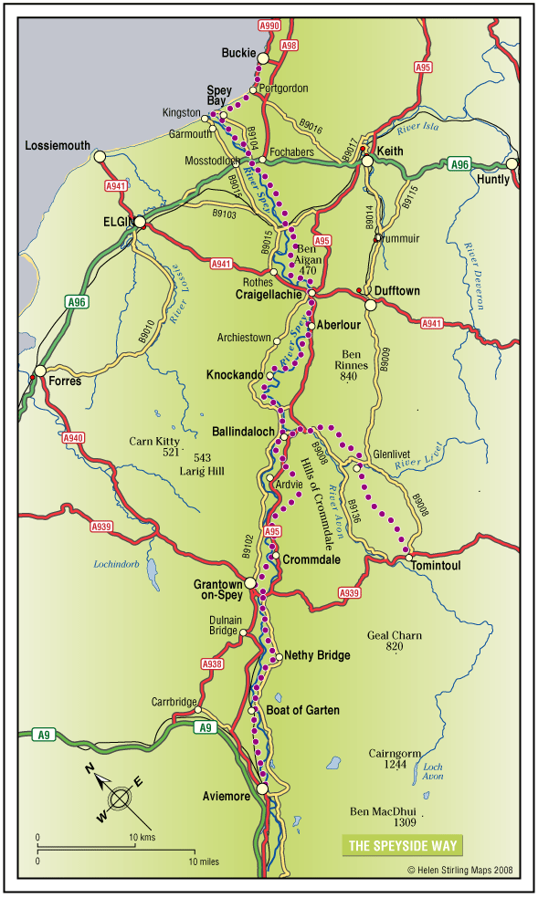
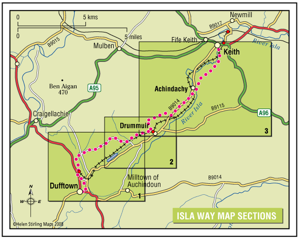
The Moray Coast Trail

The coastline and settlements of Moray are linked by a waymarked coastal trail of approximately 50 miles from Findhorn to Cullen and all the places between. The route can be extended from Findhorn to Forres along a section of cycle route.

  • Accessibility: Suitable for a wide range of users

    Many sections of the route can be used for cycling and horseriding in addition to walking. In wilder locations the path can be steep and rough in places, which would restrict access. Generally the route is most accessible in the vicinity of the coastal settlements. Less able users should concentrate on using these sections.

  • Terrain: Varied surfaces

    There are varied surfaces including tar, gravel and earth paths, with some beach and rock sections. In places the trail follows pavements through the towns and villages, whilst in other areas the route uses rough tracks along the coastal clifftops and forests.

  • Gradient: Generally level

    Generally level with some short steep climbs in places.

  • Barriers: Some barriers

    There are steps and gates in some sections, particularly along the rugged coastline at the Hopeman Ridge and between Buckie and Cullen.The route crosses Lossiemouth and Cullen beaches at low tide, but at high tide you will have to follow an alternative (unsigned) foreshore route.The section between Lossie and Kingston has the military firing range and when in use red flags are hoisted at each corner which prevent users from progressing further, for information on which days the range is being used telephone Fort George on 0131 310 8692.

  • Fully signed

The Moray Way

The Moray Way is Moray’s unique long-distance circular route, which follows the Moray Firth coast, crosses over moorland and tracks the river Spey. Few walks can match the range of scenery and wildlife found along the Moray Way. It can be walked comfortably in five to nine days.

  • Accessibility: Suitable for a wide range of users

    The route is primarily promoted for walking. Sections which make use of old railway lines are suitable for mountain bikes. The beach sections of the Way are ideal for horse riding. Sections of the Speyside Way along the old railway are suitable for horse riding. Cycling and horse riding on other sections of the way is not recommended due to physical condition and consideration for other users.

  • Terrain: Varied surfaces

    There are a wide variety of surface types that make up the route ranging from sandy dunes to minor metalled roads.

  • Gradient: Mixed gradient

    The Moray Coast Trail section is mostly flat with a rougher section between Burghead and Lossiemouth. The Dava Way involves gentle ascent and decent following the old railway line. The Speyside Way is mostly flat where it follows minor roads, tracks and an old railway, but has steep sections at Ben Aigen and near Cromdale.

  • Barriers: Some barriers

    Long sections of the route are free from barriers which would impede access. There are some stiles, gates and short flights of steps along the route. Steps are mostly to be found between Burghead and Lossiemouth and at varying points on the Speyside Way. There are no gates or stiles on the Moray Coast Trail but there are several on the Speyside Way and the Dava Way.

  • Fully signed

The Speyside Way

The Speyside Way is one of Scotland’s four official Long Distance Routes (LDRs). It runs between Aviemore, at the heart of Strathspey, 66 miles to Buckie, on the Moray Firth. The route passes through some of Scotland’s most beautiful landscapes; by rivers and mountains, over moorland and along forest paths. It includes a spur to Tomintoul, an additional 15 miles. 

  • Accessibility: Suitable for a wide range of users

    All of the route suitable for walkers. The route between Fochabers and Ballindalloch and between Nethy Bridge and Aviemore is suitable for cycling. The route is suitable for horseriding between Craigellachie and Ballindalloch.

  • Terrain: Varied surfaces

    The route offers mainly easy walking on low ground (a mixture of seashore, river valley, old railway and moorland). It should be noted that the section between Ballindalloch and Grantown is more strenuous and the Tomintoul Spur is also steeper and passes through very exposed locations.

  • Gradient: Short steep sections

    Most of the route is fairly level with some gentle slopes, although there are some steeper sections between Ballindalloch and Grantown. The Tomintoul Spur climbs to around 1,800ft above sea level at two locations.

  • Many barriers
  • Fully signed

Tiendland Trails

Teindland is a large forest south-east of Elgin with an extensive network of roads and tracks that can be explored.

    Tomintoul – Carn Daimh

    Cairn Daimh (Hill of the Stags) at 1866ft (570m) is most often ascended in the course of following the Tomintoul Spur of the Speyside Way, between Glenlivet and Tomintoul.

    • Partly signed

    Tomintoul – Old Military Road

    This linear walk follows the old military road out of Tomintoul heading to Alltachbeg. The track is undulating and wide but rutted and muddy in parts, needing sturdy footwear or wellies depending on how wet it is. The views are tremendous though, and worth the effort to see the hills and open heather moorland stretching out before you.

    • Unsuitable for wheelchairs and buggies
    • Terrain: Uneven terrain

      Gravel track - pot holed and can be muddy in wet weather.

    • Undulating
    • No barriers

    Tomintoul – Village Walk

    This is a linear walk which includes the all abilities route at Glenlivet Estate Office and Visitor Centre. The Visitor Centre has toilets and there are seats and benches throughout the walk.

    • Accessible for all users
    • Paved footpaths & roads
    • Generally level