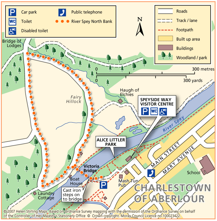
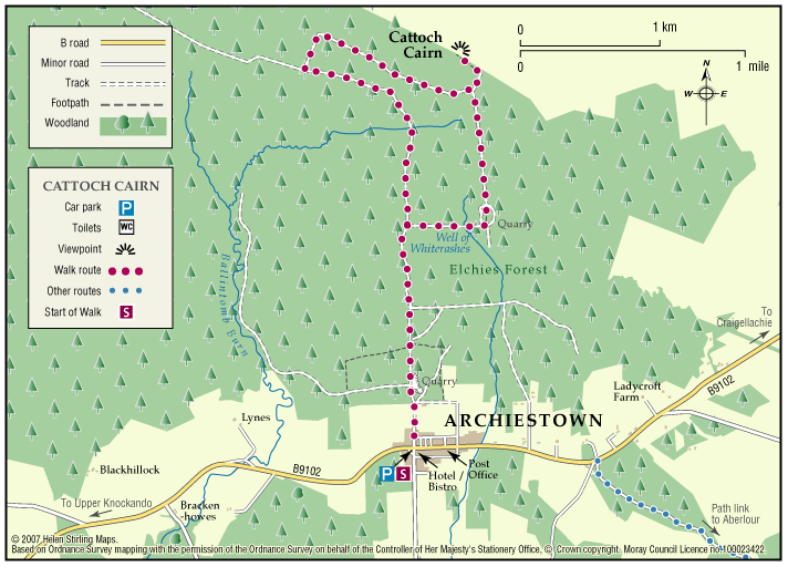
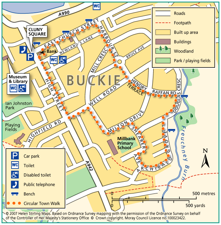
Aberlour – Alice Littler Park

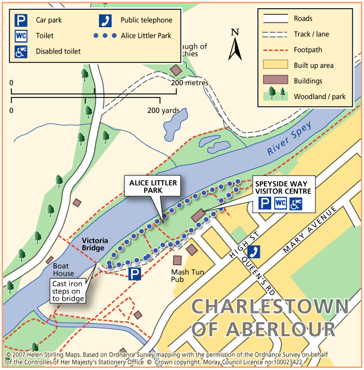
This circular walk round Alice Littler Park is flat and on good paths, making it suitable for wheelchairs and buggies. The path follows the course of the River Spey as it speeds through Aberlour, under the amazing Victoria Bridge. The park itself is full of flower beds and shrubs making this a lovely walk throughout the year. The Speyside Way Visitor Centre is open from March to October and is worth a look in to discover the history and wildlife of the area.

  • Accessible for all users
  • Paved footpaths & roads
  • Generally level
  • Unsigned

Aberlour – River Spey North Bank

This circular route crosses the River Spey at the Victoria Bridge and follows tracks through beautiful wooded countryside. There are some long moderate inclines. There is a flight of cast iron steps to negotiate getting on to the bridge from the car park, making it unsuitable for wheelchairs and buggies.

  • Accessibility: Accessible for all with care

    May be suitable for wheelchairs and buggies with care if joined from the highest point near 'Bridge of Lodges'

  • Terrain: Varied surfaces

    Estate tracks, short tarred section.

  • Gradient: Mixed gradient

    Long moderately steep incline / decline.

  • Barriers: Some barriers

    Steps onto the bridge.

Archiestown – Cairn Cattoch

Cairn Cattoch Walk is one of several waymarked walks within the forest to the north of Archiestown.

  • Accessibility: Suitable for a wide range of users

    The route is suitable for a wide range of users, although cyclists may require to dismount on the short section to the viewpoint

  • Terrain: Forest tracks

    Mainly on forest track. There is a short section of rough earth path through heather to reach the summit viewpoint. Stout footwear is advised

  • Gradient: Mixed gradient

    Long gentle climb along most of route, with a steeper section leading to the viewpoint. A total climb of 130 metres (390ft) with the summit sitting at 369 metres (1120ft) above sea level

  • No barriers
  • Fully signed

Archiestown – Forest Circular

This circular walk takes you deep into woodland along tracks which are not suitable for wheelchairs and buggies.

  • Unsuitable for wheelchairs and buggies
  • Terrain: Varied surfaces

    A mixture of bare earth and gravel paths. Surfaces can be muddy in places.

  • Gradient: Undulating

    Some steady inclines and declines.

  • Barriers: Some barriers

    Several narrow bridges/ platform bridges. Tree roots in places.

Archiestown – Village Walk

This circular walk round Archiestown includes some dirt tracks and fairly exposed sections which make it unsuitable for wheelchairs and buggies. It gives outstanding views of the surrounding countryside but some parts will be very muddy in wet weather and there are sections with no pavements, so care is needed along the roads.

  • Unsuitable for wheelchairs and buggies
  • Terrain: Varied surfaces

    Mixture of Tarmac paths and gravel tracks. Can be muddy in wet weather. Can also be quite exposed.

  • Gradient: Undulating

    Some gentle inclines and declines.

Archiestown Woods

This is a circular route of about twelve miles through forestry and on quiet public roads. It connects with the Speyside Way and the Drum Wood circular route. The Mannoch Road is an ancient right of way that runs from Elgin to Knockando; the name comes from the Gaelic work for monk.

    Auchindachy and Mill of Towie Walks

    Both of these walks are part of a network of waymarked and signed paths around Keith. Straddling both sides of the valley of the River Isla, the routes venture from the town into the delightful open countryside to the south of the town. Ramble along the country lanes and take in the rich scenery and extensive views to the hills and mountains.

    • Unsuitable for wheelchairs and buggies
    • Terrain: Varied surfaces

      Both routes are mainly on tarred minor roads with some sections on farm tracks and grass/earth paths. Some sections can be muddy and overgrown at times, so sturdy footwear is advised.

    • Gradient: Undulating

      Generally undulating with a few steady gradients in places.

    • Barriers: Some barriers

      Several field gates along both routes and a narrow bridge with a step at Braehead (there is a ford along side which may be used by horses).

    • Fully signed

    Balloch Wood and Hill

    The Balloch forest covers about 2,500 acres and has a network of forest roads so a variety of routes are possible.  At the southwest end you can follow part of Governor Caulfeild’s military road, built about 1750, which ran from Stonehaven to Fochabers.

      Ben Aigan

      Ben Aigan lies to the east of Rothes, the north east of Craigellachie and to the east of the River Spey which flows along the foot of its western and northern slopes. Rising to a height of 471m (1546 feet) and extensively forested apart from the summit cone, the top of Ben Aigan provides magnificent views over Speyside, south to Ben Rinnes, and away to the north over the Moray Firth to the hills of Sutherland

      • Unsuitable for wheelchairs and buggies
      • Defined hill path
      • Slopes throughout
      • Partly signed

      Ben Aigan and Knockmore

      This ride takes you to the transmitter on Knockmore, the summit of Ben Aigan and stunning views of Speyside. The route described is not way-marked by the Forestry Commission as a horse-riding trail.

      • Terrain: Varied surfaces

        Mostly forest roads, some open moorland and one steep grassy track. The climb to the summit is very stony.

      • Mixed gradient

      Ben Avon from Tomintoul

      Ben Avon is the most easterly mountain of the main Cairngorm range. It occupies a vast area to the north-east of Glen Quoich stretching towards Inchrory and the River Gairn, and it is recognisable from many viewpoints across Moray by the granite tors on the skyline of its long flat plateau.

      • Unsuitable for wheelchairs and buggies
      • Defined hill path
      • Slopes throughout
      • Some barriers
      • Unsigned

      Ben Rinnes

      Ben Rinnes is the highest freestanding mountain in Moray at 2733ft (841 metres), and is classified as a ‘Corbett’ – a summit lying between 2500ft and 2999ft. 

      • Unsuitable for wheelchairs and buggies
      • Defined hill path
      • Slopes throughout
      • Unsigned

      Brodie – Castle Path

      Brodie Castle has a variety of paths offering a wide choice of scenic and historic features along the routes.

      • Accessibility: Accessible for all users

        The path around the pond and the woodland paths are suitable for wheelchairs and mobility scooters.

      • Forest tracks
      • Generally level
      • Barriers: Some barriers

        There is a gated single track road crossing between the Castle and the pond walk

      Buckie – Barhill Circular

      This is a circular walk along level roads and pavements and is suitable for wheelchairs and buggies. It includes great views from Seafield Hospital and Seaview Road, where there are benches to enjoy the panorama.

      • Accessible for all users
      • Paved footpaths & roads
      • Generally level
      • Partly signed

      Buckie – Circular Town Walk

      Although this circular walk is in town, there are excellent views of countryside and over the Moray Firth, making it an enjoyable walk any time of year. The route is along level paved surfaces and it is suitable for wheelchairs and buggies. There are benches and seats along the route.

      • Accessible for all users
      • Paved footpaths & roads
      • Gradient: Undulating

        Slight hill at Douglas Crescent.

      • Unsigned

      Buckie – Gollachy Circular

      This route explores the coast west of Buckie as far as the village of Portgordon, returning at a higher level with extensive views over the Moray Firth.

      • Accessible for all users
      • Terrain: Varied surfaces

        Tarred pavements and gravel paths. A short section of earth path at Gollachy Burn can be muddy.

      • Gradient: Short steep sections

        Short steep section climbing up to the golf course near the Gollachy Burn

      • Fully signed

      Buckie – Laird’s Way to Drybridge

      The peaceful village of Drybridge sits above Buckie surrrounded by woods and farmland. Follow the way from Buckie over the Buckie Burn and past the distillery. On the way to Drybridge you will be rewarded with fine views over farmland and beyond to the Firth.

      • Fully signed

      Buckie – Mill of Buckie Circular

      This circular walk is along country lanes, tracks and paved streets and is not suitable for wheelchairs or buggies. Parts of the route can be muddy in wet weather.

      • Unsuitable for wheelchairs and buggies
      • Terrain: Varied surfaces

        Tarmac pavements and farm track which can be muddy.

      • Generally level
      • Barriers: Some barriers

        Narrow bridge with steps at Mains of Buckie.

      • Partly signed