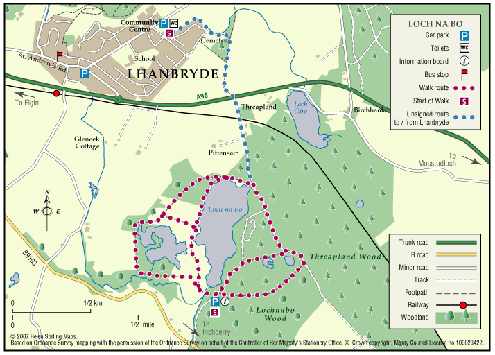
Lhanbryde – Loch Na Bo Walks

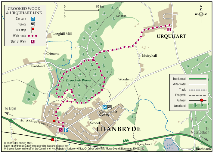
Located just a few miles east of Elgin, the woodland and countryside around the village of Lhanbryde provide a great opportunity for outdoor access.

  • Unsuitable for wheelchairs and buggies
  • Terrain: Varied surfaces

    Pavements, farm tracks and informal woodland paths (gravel and earth). Some paths can be muddy in places, so stout footwear is recommended.

  • Generally level
  • Barriers: Some barriers

    Crossing of the busy A96 road - great care required.

  • Partly signed

Logie – Dunearn Path

Dunearn path is in the Darnaway Forest and is about one mile south of Conicavel village, it is a circular route, part of which follows close to the River Findhorn. Be aware, the path in sections is very close to the edge of steep drops down to the river.

  • Accessibility: Suitable for a wide range of users

    The route is suitable for a wide range of users but the terrain might prove difficult for the less able.

  • Terrain: Forest tracks

    A mixture of woodland earth, aggregate and forest vehicle track. The path can be very wet and muddy in places, in winter time small sections of the path can be covered with leaves so making it very slippy.

  • Barriers: Some barriers

    A narrow footbridge and several wooden walkways with small sets of steps to negotiate.

  • Fully signed

Logie – Estate Paths

There are two dramatic river walks located on the Logie Estate within the beautiful Findhorn Valley, near the town of Forres. They start at the Logie Steading Visitor Centre, which houses the River Findhorn Heritage Centre, and has Arts and Crafts, Shopping, Walled Gardens, River Walks, an Adventure Playground and Café.

  • Unsuitable for wheelchairs and buggies
  • Terrain: Varied surfaces

    The paths are narrow and steep sided in places.

  • Fully signed

Logie – Sluie path

The path is a circular route through woodland, and the sections which follow the river Findhorn are very close to the cliff edge. The path is approximately three miles south of Forres.

  • Accessibility: Suitable for a wide range of users

    The route is suitable for a wide range of users but the terrain might prove difficult for the less able

  • Terrain: Forest tracks

    Mostly a woodland earth path with narrow aggregate sections, and rough vehicle tracks.

  • Gradient: Undulating

    Be aware the path is undulating and is close to steep cliffs at parts,

  • Barriers: Some barriers

    Many protruding tree roots crossing the path

  • Partly signed

Lossiemouth – Forest by the Firth Trail 

The town commands the prominent headland at the mouth of the River Lossie. It has dramatic and beautiful beaches, wonderful countryside and plenty to see and do. Part of the route follows the long-distance Moray Coast Trail. 

  • Accessibility: Unsuitable for wheelchairs and buggies

    Due to the loose sand and shingle, the route is unsuitable for wheelchairs, buggies or road bikes.

  • Terrain: Varied surfaces

    The route follows the sandy beach, with areas of loose shingle, and forest tracks. The trail can also be damp through the salt marsh area. Sturdy footwear is advised.

  • Gradient: Generally level

    Relatively level, except short steep shingle ridge of around 2 metres in height.

  • Barriers: Some barriers

    During high Spring Tides the route may be impassable along the beach. The trail requires a short scramble over a steep section of loose shingle (approx 2 metre height) to the dunes. Access to the beach is over a long narrow timber bridge.

  • Partly signed

Lossiemouth – Golf Course Walk

This walk takes you across the golf course to the beach look out and back. Buggies and wheelchairs can use the track with care. It has views of the Covesea Lighthouse and over the Moray Firth. It can be a little exposed if the wind is strong. Watch out for jets from RAF Lossiemouth overhead and keen golfers on the course!

  • Accessible for all with care
  • Varied surfaces
  • Generally level
  • No barriers

Lossiemouth – Harbour Circular Walk

This is an extension of the Harbour Walk, up to James Square. It includes a small steep slope down Hill Street.

  • Accessibility: Accessible for all with care

    Suitable for wheelchairs, with care on slope.

  • Paved footpaths & roads
  • Gradient: Short steep sections

    One short but steep section of decline.

Lossiemouth – Harbour Walk

This is a walk from Seatown to the Harbour and back again. It is all along good paths and is suitable for wheelchairs and buggies. It has lovely views of the East Beach and the boats in the harbour. There are toilets on Clifton Road, near the bakers and in Station Park, and benches along the way.

  • Accessible for all users
  • Paved footpaths & roads
  • Generally level
  • No barriers

Lossiemouth – Skerry Brae Walk

This is a circular walk on good footpaths and is suitable for wheelchairs and buggies. The route can be extended to include the Golf Course Walk, which would then be a Level 3 walk of 2 ¼ miles and take between 45 and 60 minutes.

  • Accessibility: Accessible for all with care

    Suitable for wheelchairs and buggies, though be aware of the fairly steep section.

  • Paved footpaths & roads
  • Gradient: Short steep sections

    Fairly steep but steady decline at Tullochs Brae. Relatively level elsewhere.

Mosstodloch – Balnacoul Orange Route

This is a signposted circular route which starts on the All Abilities path and extends into the wood. The tracks are all level and suitable for buggies, although wheelchairs may struggle on the compacted earth surface.

  • Suitable for buggies but not wheelchairs
  • Terrain: Varied surfaces

    Compacted earth paths with gravel in sections. Can be muddy.

  • Generally level
  • No barriers
  • Fully signed

Mosstodloch – Gordon Baxter Way

This is a circular, level walk with good views of the countryside. The tracks can be muddy if wet and this walk shouldn’t be undertaken on a windy day as it is exposed in places.

  • Unsuitable for wheelchairs and buggies
  • Terrain: Varied surfaces

    Farm tracks and tarmac. Can be muddy.

  • Generally level

Mosstodloch – Stynie east

This is a good level walk along tracks and roads and has great countryside views. It shouldn’t be attempted in really cold or windy weather as there are places where the track is very exposed.

  • Unsuitable for wheelchairs and buggies
  • Terrain: Varied surfaces

    Country roads, farm tracks and compacted earth paths. Care to be taken on the road sections as no pavements.

  • Generally level

Mosstodloch – Stynie west

This is a circular walk from Mosstodloch, through mature forest along tarmac road and forest tracks. The tracks can be muddy when wet. Go quietly and you may see red squirrels.

  • Unsuitable for wheelchairs and buggies
  • Terrain: Varied surfaces

    A mixture of pavements, farm tracks and compacted earth paths. Can be muddy in wet weather and is quite exposed.

Mosstodloch – Webster Way

This is a circular walk along a purpose built trail for wheelchairs and buggies, through forest plantation. The tracks are good all year round and there are picnic tables at the start. This is a good opportunity for red squirrel watching as well as the woodland birdlife. This is a popular dog walking path.

  • Accessible for all users
  • Paved footpaths & roads
  • Generally level
  • No barriers
  • Fully signed

Mosstodloch – Webster Way All Abilities

This is a circular walk along a purpose built trail for wheelchairs and buggies, through forest plantation. The tracks are good all year round and there are picnic tables at the start. This is a good opportunity for red squirrel watching as well as the woodland birdlife.

  • Accessible for all users
  • Gravel path
  • Generally level
  • No barriers
  • Fully signed

Rothes – Burn Walk

This flat, circular walk follows the Rothes Burn as it passes through the Playing Fields and also includes some great views over the open countryside to Ben Aigen. The surfaces are all good and are suitable for wheelchairs and buggies, although care is needed over the footbridges.

  • Accessible for all users
  • Paved footpaths & roads
  • Generally level
  • Barriers: No barriers

    Take care crossing the footbridges.

Rothes – Spey Walk

This flat, circular walk follows the River Spey on it’s way from Craigellachie to Boat o’ Brig. The path is good but is not suitable for wheelchairs or buggies. The scenery along this walk is very beautiful at any time of year, although it can be a little exposed in places and the paths can be muddy in wet weather.

  • Unsuitable for wheelchairs and buggies
  • Terrain: Varied surfaces

    Mainly grass and earth path, with some sections of farm track and tarmac. Paths can be muddy when wet.

  • Generally level

Rothes – The Dounie

This walk follows the Rothes Burn upstream to the Giant’s Table and the Fairy Rock – volcanic outcrops worn and shaped by thousands of years of erosion – and returns by the track skirting the golf course.

  • Suitable for a wide range of users
  • Varied surfaces
  • Gradient: Mixed gradient

    Varying gradients, climbing to 250m.

  • Barriers: Some barriers

    Some steps

  • Fully signed

The Dava Way

The Dava Way is a 23 mile trail across the ancient Celtic province of Morayshire between the historic towns of Forres and Grantown-on-Spey. The route links Strathspey and the Cairngorms National Park with the Moray Coast in North East Scotland. Almost all of the route follows the old Highland Railway line and is off road and safe from traffic.

  • Accessibility: Suitable for a wide range of users

    WALKING - The surface is varied, mostly firm and good, but it can be wet and rough in places. All of it is fine for walking. CYCLING - The Dava Way can be used as an ‘off road’ cycling route, as most of it is over a firm but rough surface.

  • Terrain: Varied surfaces

    The surface of the path is generally compacted track-bed material, rough and rutted in places, and is good for walking and 'off-road’ cycling. Depending on the weather, stretches may be wet but the Dava Way Volunteers have installed new drains and this has improved the paths.

  • Gradient: Gentle gradients

    The route has a very gradual gradient which rises on the Dava Moor to 320m (1050ft) above sea level at its highest point.

  • Barriers: Some barriers

    The are a number of opening gates as you approach Grantown. There are low steps at the track end at Grantown.

  • Fully signed