The Dava Way
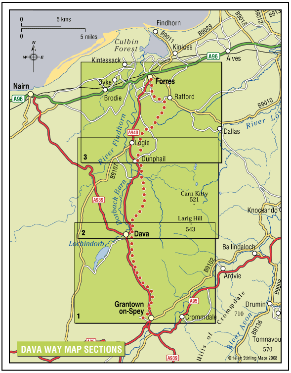
The Dava Way is a 23 mile trail across the ancient Celtic province of Morayshire between the historic towns of Forres and Grantown-on-Spey. The route links Strathspey and the Cairngorms National Park with the Moray Coast in North East Scotland. Almost all of the route follows the old Highland Railway line and is off road and safe from traffic.
- Long Distance Walk
- Challenging
- 23 miles (36.8 km)
- 12 hour(s)
- Forres, Grantown-on-Spey, Rafford
Accessibility: Suitable for a wide range of users
WALKING - The surface is varied, mostly firm and good, but it can be wet and rough in places. All of it is fine for walking. CYCLING - The Dava Way can be used as an ‘off road’ cycling route, as most of it is over a firm but rough surface.
Terrain: Varied surfaces
The surface of the path is generally compacted track-bed material, rough and rutted in places, and is good for walking and 'off-road’ cycling. Depending on the weather, stretches may be wet but the Dava Way Volunteers have installed new drains and this has improved the paths.
Gradient: Gentle gradients
The route has a very gradual gradient which rises on the Dava Moor to 320m (1050ft) above sea level at its highest point.
- Fully signed