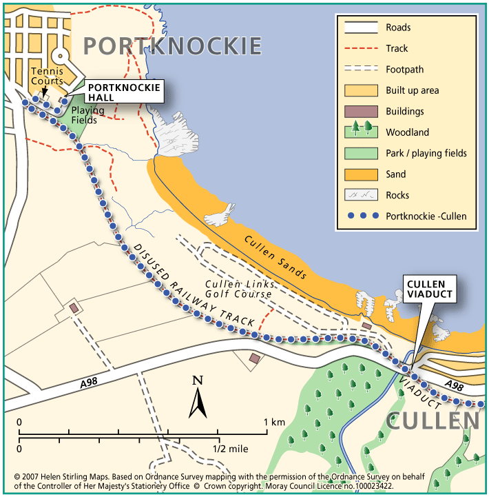
Cullen – Portknockie Cyclepath Walk

This linear walk follows the National Cyclepath which links Portknockie to Cullen via the Cullen viaduct, on what was the old railway line. It has a good level surface, which is suitable for wheelchairs and buggies. The views across Cullen Golf Course to the coast are worth the effort. Take care due to landslip.

  • Accessible for all users
  • Paved footpaths & roads
  • Generally level
  • No barriers
  • Partly signed

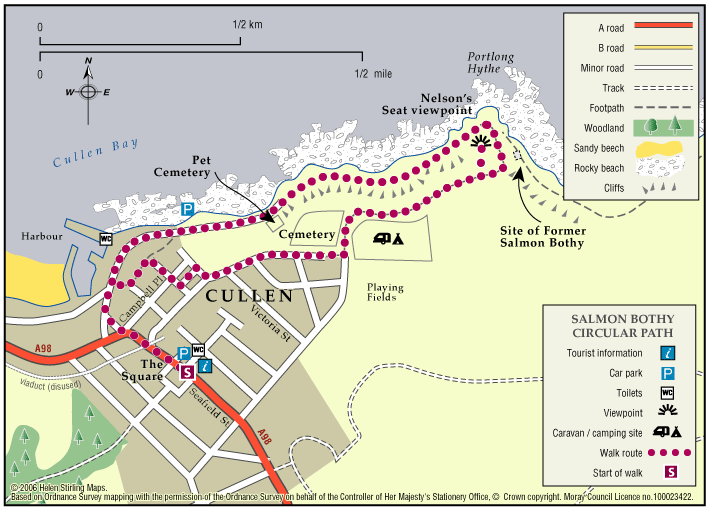
Cullen – Salmon Bothy Circular

The Salmon Bothy Circular Path provides a short coastal walk, which takes in magnificent coastal views.

  • 1.6 miles (2.56 km)
  • 40 meters (131 ft)
  • 45 minutes
  • Accessibility: Unsuitable for wheelchairs and buggies

    There is a steep ramped path with handrail leading from the harbour area up to cliff top. Flat gravel path between the caravan park and the Nelson’s Seat viewpoint providing opportunity for less able bodied users.

  • Terrain: Varied surfaces

    Fully surfaced roadside paths in the built up areas. Bound gravel paths elsewhere, with a short steep section of rough grassy path at the outlying gully. There are plans for this section to be upgraded to gravel.

  • Gradient: Mixed gradient

    Relatively flat throughout but there are two short steep sections.

  • Barriers: Some barriers

    There is a steep ramped path with handrail leading from the harbour area up to cliff top.

  • Fully signed

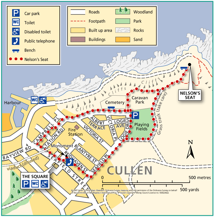
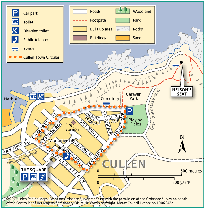
Cullen – Town Circular

Cullen is built on a hill and this circular town walk has a few steep slopes. The surfaces are good and it is suitable for wheelchairs and buggies, although it will be hard work on the slopes. There are toilets at the start and benches along the route. The views will be worth it! This walk can be extended to follow the path to Nelson’s Seat.

  • Accessibility: Accessible for all users

    The extended walk to Nelson's seat is not suitable for wheelchairs or most buggies.

  • Terrain: Paved footpaths & roads

    Gravel and grass paths on extended route to and from Nelson's Seat.

  • Gradient: Short steep sections

    Long, fairly steep descent from the town square under the viaduct, leading to a short steep section at Campbell Place. There is also a short steep decline from Reidhaven Place back down into the square.

  • No barriers
  • Fully signed

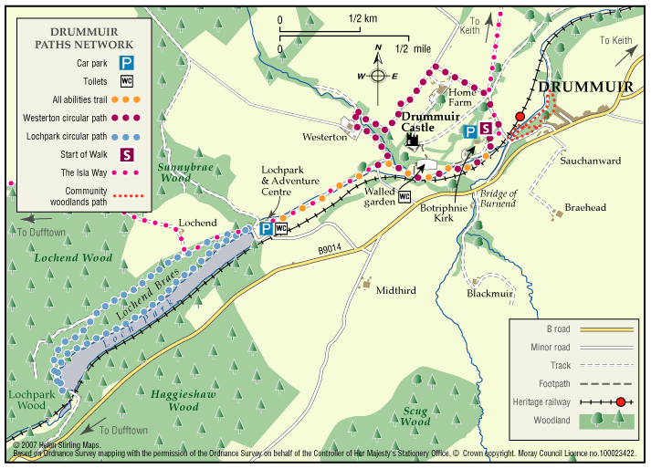
Drummuir – Paths Network

A suite of trails has been created on the Drummuir Estate developed by Drummuir 21, a local community group. Options exist for walks of approximately 40, 70 or 120 minutes duration depending on your inclination. Ideal for families. Part of the trail system is suitable for wheelchair users (about 3 miles return trip).

  • Accessibility: Accessible for all users

    The all abilities section is suitable for wheelchairs and buggies.

  • Terrain: Gravel path

    Relatively good surfaces throughout; mainly tarmac and gravel paths with a section of quiet public road. The All Abilities Trail section between the Botriphnie Kirk car park and Loch Park follows a level gravel path.

  • Mixed gradient
  • No barriers
  • Fully signed

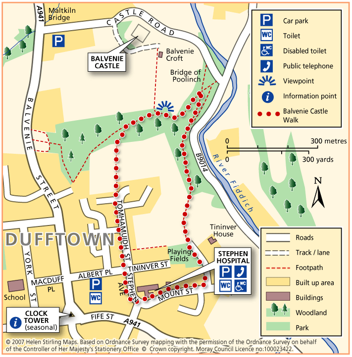
Dufftown – Balvenie Castle

This circular walk has some steep inclines and is not suitable for wheelchairs or buggies because of the terrain. It includes some woodland and has good views of the ruined castle.

  • Unsuitable for wheelchairs and buggies
  • Terrain: Varied surfaces

    Tarmac pavements, compacted earth and gravel tracks. Note that the earth track in the wood is quite narrow and can be muddy/ slippy in wet weather. Watch out for tree roots.

  • Gradient: Short steep sections

    Some steep inclines / declines, with the steepest on a ramped path section within the woodland.

  • Barriers: Some barriers

    Long flight of steps in wood.

  • Partly signed

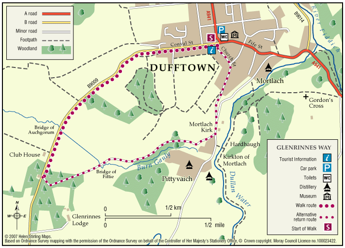
Dufftown – Glenrinnes Way

A circular walk which will take you round some of the sights of Dufftown.

  • Accessible for all users
  • Terrain: Paved footpaths & roads

    A good generally level circular route with a steady climb no matter which way round you decide to walk it

  • Gradient: Generally level

    There is a steady slope to the Tomintoul Road but the ground is good.

  • No barriers
  • Fully signed

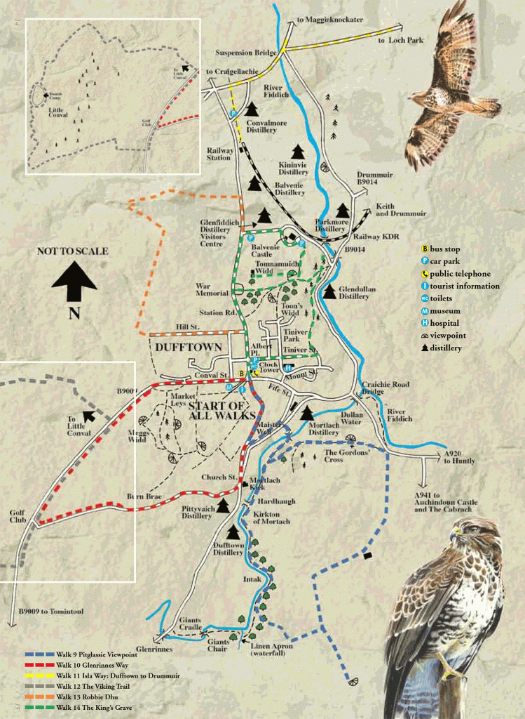
Dufftown – Kings Grave

The Kings Grave is a short path which takes in many historical events which happened in the Dufftown area.

  • Suitable for a wide range of users
  • Terrain: Varied surfaces

    Grass track. Parts may be muddy.

  • Gradient: Short steep sections

    Steady incline from Balvenie Castle.

  • Unsigned

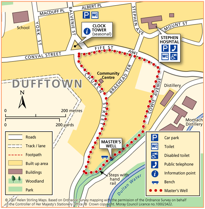
Dufftown – Masters Well

This is a short circular walk with some inclines along a variety of surfaces, from paved to woodland dirt tracks. There are some steps through the wooded area which make it unsuitable for wheelchairs or buggies. There are benches along the route.

  • Unsuitable for wheelchairs and buggies
  • Terrain: Varied surfaces

    Tarmac pavements, compacted earth and gravel tracks. Note that the earth track in the wood is quite narrow and can be muddy/ slippy in wet weather. Watch out for tree roots. The tarmac surface on Cowie Avenue is quite badly pot-holed.

  • Gradient: Short steep sections

    Several inclines / declines throughout. Note that there is a fairly steep decline down Church Street and a steady incline back up Fife Street.

  • Barriers: Some barriers

    There are steps within the woodland.

  • Partly signed

Dufftown – Pitglassie Viewpoint

Pitglassie Viewpoint is one of many walks in Dufftown, it is a circular path, but either way you have a bit of a climb.

  • Unsuitable for wheelchairs and buggies
  • Gradient: Undulating

    Steady climb from either direction

  • Unsigned

Dufftown – Robbie Dhu

Robbie Dhu path does have a steep climb but has beautiful views to make it worth the effort.

  • Suitable for a wide range of users
  • Short steep sections

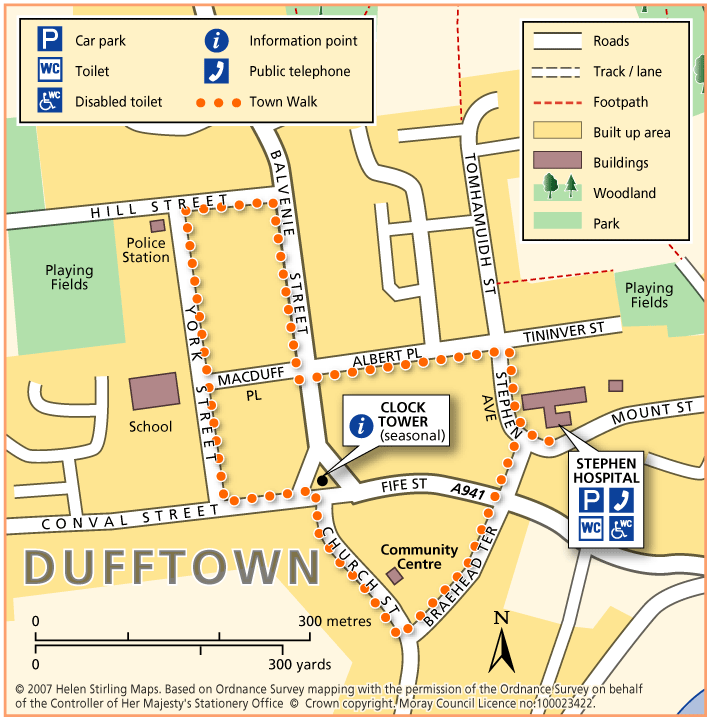
Dufftown – Town Walk

Dufftown is built on a hill and surrounded by hills, giving great views of the countryside but challenging to walkers. The Town Walk includes some inclines, but is all on good pavements and is suitable for wheelchairs and buggies.

  • Accessible for all users
  • Paved footpaths & roads
  • Undulating
  • Fully signed

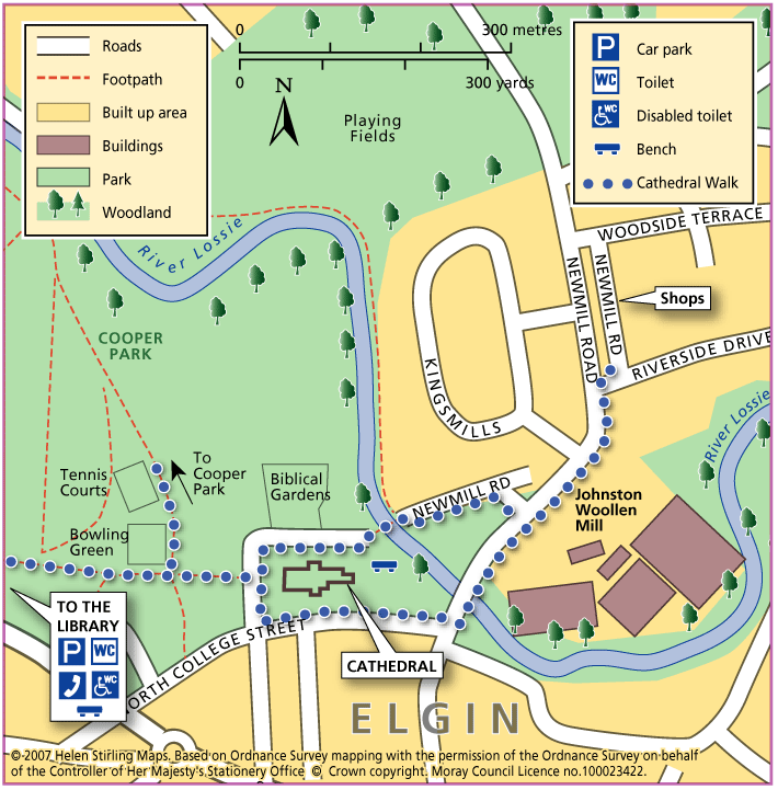
Elgin – Cathedral Walk

This short circular walk is all on good pavements and is suitable for wheelchairs and buggies. The route is very picturesque, circling the ruins of Elgin Cathedral and can be extended by taking the path into Cooper Park.

  • Accessible for all users
  • Paved footpaths & roads
  • Generally level
  • No barriers
  • Unsigned

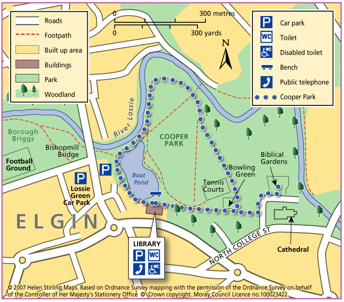
Elgin – Cooper Park Walk

This is a flat, circular route along paths taking you round Cooper Park, suitable for wheelchairs and buggies. This is a pleasant walk through the Park, on good paths. There are toilets in the Library and the café is open between 10am and 4pm.

  • Accessible for all users
  • Paved footpaths & roads
  • Generally level
  • No barriers
  • Unsigned

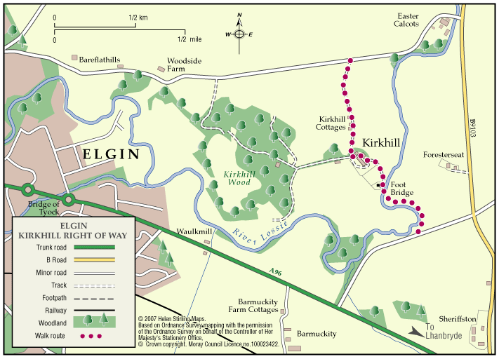
Elgin – Kirkhill Right of Way

The Kirkhill path is part undulating earth surface and part tar road surface which is well used by local fisherman and runs for part of its length alongside the River Lossie.

  • Terrain: Varied surfaces

    Part tarmac and earth path. Earth path section (prone to flooding and muddy when wet) has livestock grazing on occasions.

  • Generally level
  • Barriers: Some barriers

    The route has three kissing gates and narrow bridge to negotiate.

  • Fully signed

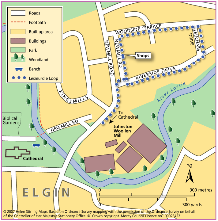
Elgin – Lesmurdie Loop

This is a short circular, well – lit walk on flat pavements, suitable for wheelchairs and buggies.

  • Accessible for all users
  • Paved footpaths & roads
  • Generally level
  • No barriers
  • Fully signed

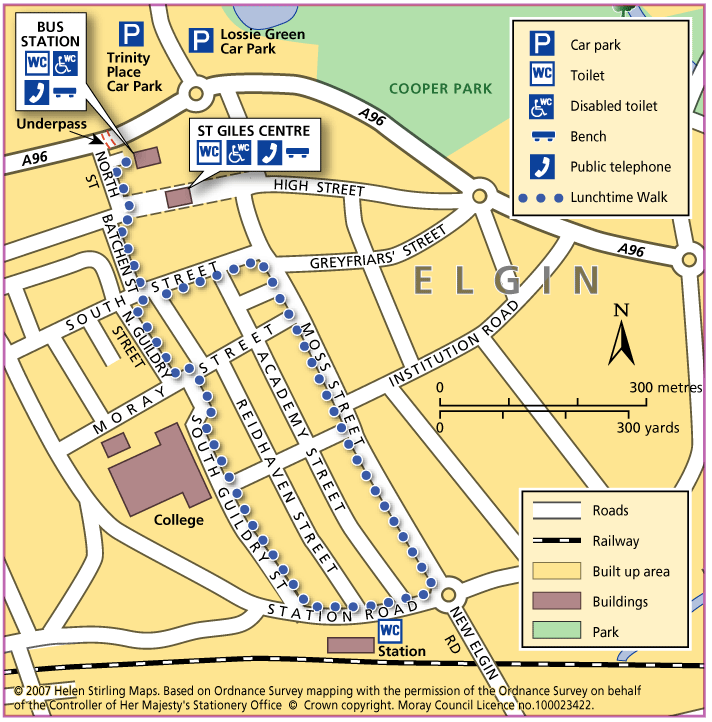
Elgin – Lunchtime Walk

This is a circular walk through Elgin, starting at the bus station. It routes south past the shops on Batchen Street and then into the residential area beyond, with its old stone built terraces and villas. There are plenty of views out to the countryside and hills to the south of Elgin.

  • Accessible for all users
  • Paved footpaths & roads
  • Gradient: Undulating

    There are some long slow inclines/ declines, particularly along Batchen Street and Moss Street.

  • No barriers

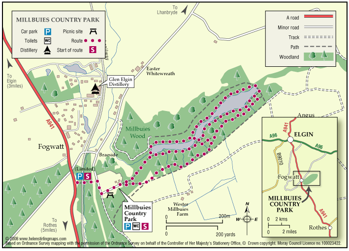
Elgin – Millbuies Country Park

Millbuies Loch was created by the damming of streams to provide angling facilities on the loch.Moray District Council took over the estate in 1975 and the fishing was extended to the public.

  • Unsuitable for wheelchairs and buggies
  • Terrain: Gravel path

    Gravel or soil paths. Sections of the route are not suitable for buggies or wheelchairs.

  • Gradient: Undulating

    Generally level although there is a steep gradient down to the Loch.

  • Barriers: Some barriers

    Some steps, walkboards and bridges.

  • Partly signed

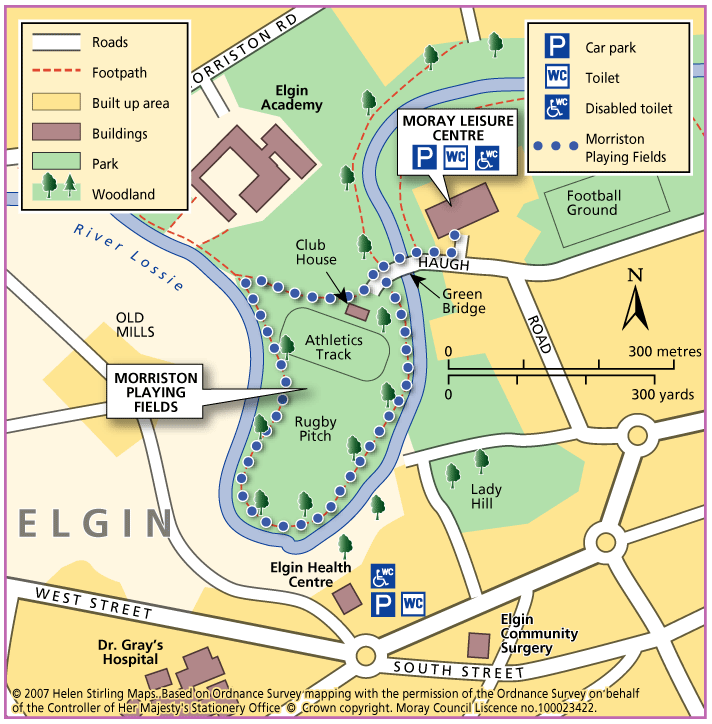
Elgin – Morriston Playing Fields

This circular walk follows the path round Morriston Playing Field, by the banks of the River Lossie. The path is flat but needs some care. It is suitable for most buggies but not wheelchairs.

  • Accessibility: Suitable for buggies but not wheelchairs

    Suitable for most buggies but may be be difficult during wet periods. Wheelchairs may struggle due to some uneven surfaces.

  • Terrain: Varied surfaces

    Gravel footpaths. Can be muddy/ slippy in wet weather, and liable to flooding. Also watch out for fallen leaves during the winter.

  • Generally level
  • No barriers

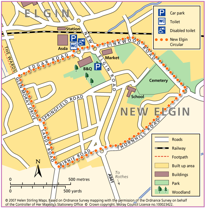
Elgin – New Elgin Circular

This is a circular walk, which starts in Edgar Road and loops round south Elgin. It is all on good pavements and is suitable for wheelchairs and buggies.

  • Accessible for all users
  • Paved footpaths & roads
  • Gradient: Generally level

    Mainly level with some steady inclines and declines.

Elgin – Pinefield Park

This is a circular walk, which includes the path through Pinefield Park. The route is all on good pavements and paths and is suitable for wheelchairs and buggies.

  • Accessible for all users
  • Paved footpaths & roads
  • Generally level
  • No barriers