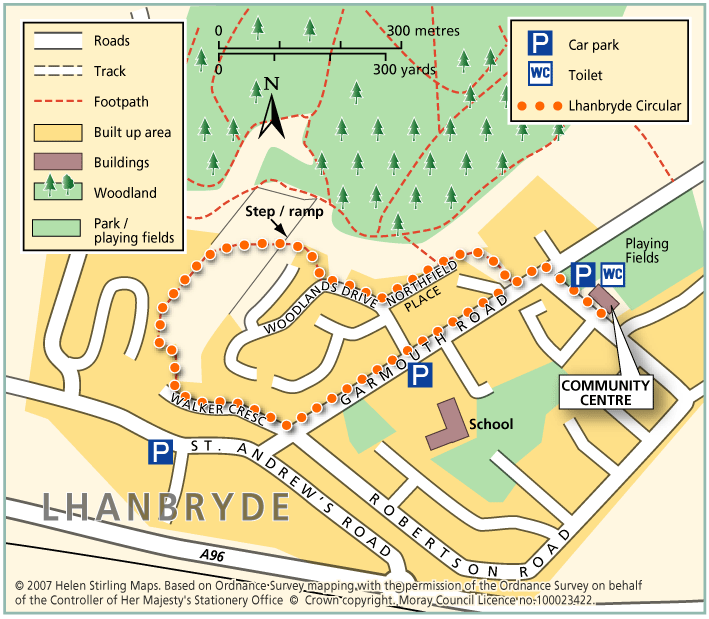
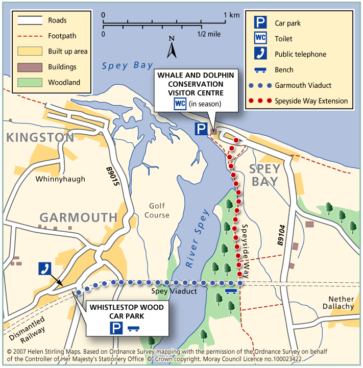
Hopeman – Beach and Lodge Walk

This is an extension of the Level 1 Beach Walk, following the coast path past the beach huts and turning inland up Lodge Lane.

  • Unsuitable for wheelchairs and buggies
  • Terrain: Varied surfaces

    Mainly tarmac pavements and paths, but gravel section at Lodge Lane. Care to be taken on Lodge Lane, which can be muddy in wet weather.

  • Gradient: Short steep sections

    Steady incline up lodge lane. Relatively level elsewhere.

Hopeman – Beach Walk

This walk is from the Surgery on Harbour Street to the Pagoda viewpoint on East Beach and back again. The paths are good and suitable for wheelchairs and buggies. There are toilets at the bottom of Harbour Street and plenty of benches along the way. This walk can be a little exposed if the wind is strong.

  • Accessible for all users
  • Paved footpaths & roads
  • Generally level
  • No barriers

Hopeman – Railway Path

This walk takes you from Hopeman Surgery on a circular route along part of the old railway line to Cummingston. It is quite sheltered along the old track and has lovely views over the Moray Firth with potential to spot dolphins. The section from Cummingston back towards Hopeman is along a pavement next to a relatively busy road so care will be required.

  • Unsuitable for wheelchairs and buggies
  • Terrain: Varied surfaces

    Gravel paths and tarmac pavements.

  • Gradient: Generally level

    Relatively level, with short downwards slope to the old railway line in Hopeman and short steep incline to the bridge near Cummingston.

  • Barriers: Some barriers

    Steps down to railway path at the Hopeman end.

  • Partly signed

Keith – Broomhill Circular

This is a circular walk which includes Broomhill Cemetery. The route includes a beautiful tree lined path and a farm track, which can be quite exposed in bad weather. It is not suitable for wheelchairs or buggies. This route can join up with St Rufus Park Walk by turning right into the park off Broomhill Road.

  • Unsuitable for wheelchairs and buggies
  • Terrain: Varied surfaces

    A combination of roadside pavements, a tarmac footpath through the cemetery and a long section of gravel farm track. Take care on the track which is rather potholed and can be muddy in wet weather.

  • Gradient: Undulating

    Some gentle inclines.

  • Barriers: Some barriers

    Quite heavy gate at Broomhill cemetery.

Keith – Cuthil Park Circular

This is a circular walk round Keith, following the little lanes that criss-cross the town. The surfaces are suitable for wheelchairs and buggies and the route is fairly level apart from a steady climb from Turner Street to Cuthill Park. There are benches at the start and at Cuthil Park.

  • Accessible for all users
  • Paved footpaths & roads
  • Gradient: Undulating

    Steady climb from Turner St to Cuthil Park. Relatively level elsewhere.

Keith – Denwell / Braehead Circuit

The route can be enjoyed in both directions, starting and finishing at the map information board in Keith Square (Reidhaven Square). As parts of the route cross open countryside and have a variety of path surfaces, stout footwear and waterproof clothing are recommended.

  • Accessibility: Suitable for a wide range of users

    The minor road sections are suitable for people of a wide range of abilities.

  • Terrain: Varied surfaces

    A combination of rough grass paths and sections of minor tarred road.

  • Gradient: Generally level

    A few gentle gradients on the Brandy Brae path.

  • No barriers
  • Fully signed

Keith – Fife Keith Park

This is a pleasant circular walk, through town and woodland, including Cottage Wood. There are some long gradual slopes in the walk and the woodland paths need care, especially when wet. It is also fairly exposed in places and is not suitable for wheelchairs or buggies.

  • Unsuitable for wheelchairs and buggies
  • Terrain: Varied surfaces

    A mixture of tarmac pavements, bare earth woodland paths and a country road. Although reasonably quiet, please be vigilant of traffic on the road section.

  • Gradient: Undulating

    A few long gradual slopes.

  • Barriers: Some barriers

    Steps - located at entrance to Cottage Wood.

Keith – Horse Market Circular

This is a circular, level walk past fields of horses. There are benches in the Square and 1 along Edindiach Road. Pavements are good and the walk is suitable for wheelchairs and buggies.

  • Accessible for all users
  • Paved footpaths & roads
  • Generally level

Keith – Kynoch Park Circular

This is a circular walk linking Reidhaven Square to Keith Community Centre. There are benches in the Square and also at the Community Centre. Pavements are good and it is suitable for wheelchairs and buggies. This walk can be added to the Horse Market Circular to make a Level 3 walk of just over 2 miles.

  • Accessible for all users
  • Paved footpaths & roads
  • Gradient: Generally level

    Mainly level, but a gentle incline at School Road.

  • No barriers

Keith – Simpson Memorial Park

This is a circular walk which takes you round Simpson Memorial Park. It is mostly on pavements and good paths, apart from a short stretch of grass path which could be muddy in the wet. It is suitable for wheelchairs and buggies if dry and is fairly flat apart from the section along Drum Road.

  • Accessibility: Accessible for all with care

    Can be used by buggies and wheelchairs during dry weather.

  • Terrain: Varied surfaces

    Mostly on tarmac pavements and paths. Grass path at Simpson park - which can be muddy in wet weather.

  • Gradient: Undulating

    Long but steady climb up Drum Road. Relatively flat elsewhere.

Keith – St Rufus Park Circular

This circular walk includes some very interesting parts of Old Keith, Strathisla Distillery, Milton Tower and Keith and Dufftown Old Railway Station. There are some steep sections, which would make it unsuitable for wheelchairs. There are benches at the start and along the way.

  • Unsuitable for wheelchairs and buggies
  • Terrain: Varied surfaces

    A combination of roadside pavements, a tarmac footpath through the cemetery and a long section of gravel farm track. Take care on the track which is rather potholed and can be muddy in wet weather.

  • Undulating

Keith – The Green Roadies

Enjoy the many different species of flowers, shrubs and birds that can be identified. Marvel at the fine views of all the surrounding hills that can be seen across green fields and farmland.

  • Unsuitable for wheelchairs and buggies
  • Terrain: Varied surfaces

    A combination of tarred roadside paths, minor roads, aggregate paths and rough grassy tracks. The grassy track sections, although flat, are muddy in places and can be difficult to negotiate.

  • Gradient: Generally level

    A few gentle gradients in places.

  • Barriers: Some barriers

    Several gates at the cemetery.

  • Fully signed

Lhanbryde – Circular

This circular walk is part of the Lhanbryde Paths Network. There are a variety of walking surfaces on this walk, including dirt paths, grass verges and pavements, which make it unsuitable for wheelchairs and buggies. There are also a few steps, which need caution.

  • Unsuitable for wheelchairs and buggies
  • Terrain: Varied surfaces

    A mixture of surfaces: pavements, grass, compacted earth and gravel paths.

  • Gradient: Short steep sections

    Mainly level but some short sections of incline/ decline.

  • Barriers: Some barriers

    Stepped ramp

Lhanbryde – Crooked Wood and Urquhart

Located just a few miles east of Elgin, the woodland and countryside around the village of Lhanbryde provide a great opportunity for outdoor access.

  • Unsuitable for wheelchairs and buggies
  • Terrain: Varied surfaces

    Informal earth path within the woodland, with several short steep sections. Generally dry but can be muddy in places, so stout footwear is recommended. There is a quiet section of public road between Crooked Wood and Urquhart.

  • Gradient: Short steep sections

    Although generally level or gently undulating, there are some short steep sections, particularly within the woodland.

  • Barriers: Some barriers

    A flight of steps near the entrance to the wood. Two short steep sections of path within the woodland are slippy when wet. Also watch out for tree roots.

  • Fully signed

Logie – Dunearn Path

Dunearn path is in the Darnaway Forest and is about one mile south of Conicavel village, it is a circular route, part of which follows close to the River Findhorn. Be aware, the path in sections is very close to the edge of steep drops down to the river.

  • Accessibility: Suitable for a wide range of users

    The route is suitable for a wide range of users but the terrain might prove difficult for the less able.

  • Terrain: Forest tracks

    A mixture of woodland earth, aggregate and forest vehicle track. The path can be very wet and muddy in places, in winter time small sections of the path can be covered with leaves so making it very slippy.

  • Barriers: Some barriers

    A narrow footbridge and several wooden walkways with small sets of steps to negotiate.

  • Fully signed

Logie – Estate Paths

There are two dramatic river walks located on the Logie Estate within the beautiful Findhorn Valley, near the town of Forres. They start at the Logie Steading Visitor Centre, which houses the River Findhorn Heritage Centre, and has Arts and Crafts, Shopping, Walled Gardens, River Walks, an Adventure Playground and Café.

  • Unsuitable for wheelchairs and buggies
  • Terrain: Varied surfaces

    The paths are narrow and steep sided in places.

  • Fully signed

Logie – Sluie path

The path is a circular route through woodland, and the sections which follow the river Findhorn are very close to the cliff edge. The path is approximately three miles south of Forres.

  • Accessibility: Suitable for a wide range of users

    The route is suitable for a wide range of users but the terrain might prove difficult for the less able

  • Terrain: Forest tracks

    Mostly a woodland earth path with narrow aggregate sections, and rough vehicle tracks.

  • Gradient: Undulating

    Be aware the path is undulating and is close to steep cliffs at parts,

  • Barriers: Some barriers

    Many protruding tree roots crossing the path

  • Partly signed

Lossiemouth – Golf Course Walk

This walk takes you across the golf course to the beach look out and back. Buggies and wheelchairs can use the track with care. It has views of the Covesea Lighthouse and over the Moray Firth. It can be a little exposed if the wind is strong. Watch out for jets from RAF Lossiemouth overhead and keen golfers on the course!

  • Accessible for all with care
  • Varied surfaces
  • Generally level
  • No barriers

Lossiemouth – Harbour Circular Walk

This is an extension of the Harbour Walk, up to James Square. It includes a small steep slope down Hill Street.

  • Accessibility: Accessible for all with care

    Suitable for wheelchairs, with care on slope.

  • Paved footpaths & roads
  • Gradient: Short steep sections

    One short but steep section of decline.

Lossiemouth – Harbour Walk

This is a walk from Seatown to the Harbour and back again. It is all along good paths and is suitable for wheelchairs and buggies. It has lovely views of the East Beach and the boats in the harbour. There are toilets on Clifton Road, near the bakers and in Station Park, and benches along the way.

  • Accessible for all users
  • Paved footpaths & roads
  • Generally level
  • No barriers